US Highway 21
| map | |
|---|---|

|
|
| Basic data | |
| Overall length: | 395 mi / 636 km |
| Opening: | 1926 |
| States: |
South Carolina North Carolina Virginia |
| Starting point: | Hunting Island State Park |
| End point: |
|
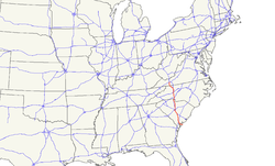
The US Highway 21 (short US 21 ) is a United States highway in the United States . It begins at Hunting Island State Park in the state of South Carolina and ends after 396 miles on Interstate 81 and US Highway 52 in Wytheville , Virginia .
course
South carolina
US Highway 21 begins at Hunting Island State Park on the coast of the Atlantic Ocean. After looping around the state park, the highway runs north. Between Gardens Comer and the junction northeast of Yemassee , he uses the route of US Highway 17 . Shortly thereafter, US 21 meets Interstate 95 . In Branchville the highway is crossed by US Highway 78 . In Orangeburg it forms a ring around the city center together with US Highway 178 and also meets US Highways 301 and 601 as well as South Carolina State Routes 4 , 21 , 33 and 178 . Between Orangeburg and Columbia , US 21 runs parallel to Interstate 26 and uses the route of US Highway 176 for a few kilometers, and US Highway 321 in the southwest of Columbia .
In Greater Columbia US Highway 21 first meets again on I-26 and after crossing the Congaree River to Interstate 126 and US Highways 1 and 378 . After the intersection with Interstate 20 , US 21 leaves the metropolitan area in a northerly direction. From Blythewood it runs parallel to Interstate 77 and the Wateree River over Rock Hill to the North Carolina border. From about one kilometer before the border, he uses the I-77 route.
North Carolina
Together with Interstate 77, US Highway 21 runs through the greater Charlotte area . The route initially meets Interstate 485 as well as Interstate 277 and US Highways 29 and 74 . About five kilometers after the intersection with Interstate 85 , US 21 separates from I-77. The highway continues to run parallel to the interstate in a northerly direction. From Cornelius onwards , they share the route again for eight kilometers.
In the center of Statesville the US 21 meets the US Highways 64 and 70 and in the north of the city on the Interstate 40 . North of Hamptonville , US Highway 21 is crossed by US Highway 421 , which was expanded as a freeway in this section. From Elkin Highway leads to the northwest, passing west of Roaring Gap to Stone Mountain State Park . From Twin Oaks the US 21 uses the route of US Highway 221 and shortly afterwards reaches the border with Virginia.
Virginia
US Highway 21 continues north in the state of Virginia. In the village of Independence , the highway separates from US 221 and is crossed by US Highway 58 at the same time . In the center of Wytheville, US 21 meets US Highway 11 . The road leaves the city in a northwesterly direction and ends after a total of 636 kilometers at Exit 70 of Interstate 81 and US Highway 52.
Feeders and bypasses
- planned US Highway 121 between Beckley and Pound
- US Highway 221 between Lynchburg and Perry
- US Highway 321 between Hardeeville and Lenoir City
- US Highway 421 between Fort Fisher and Michigan City
- US Highway 521 between Georgetown and Charlotte
Web links
- US Highway Ends (English)

