
Bildein
|
Bildein
|
||
|---|---|---|
| coat of arms | Austria map | |
 |
|
|
| Basic data | ||
| Country: | Austria | |
| State : | Burgenland | |
| Political District : | Gussing | |
| License plate : | GS | |
| Main town : | Subpicture | |
| Surface: | 15.9 km² | |
| Coordinates : | 47 ° 8 ' N , 16 ° 28' E | |
| Height : | 225 m above sea level A. | |
| Residents : | 347 (January 1, 2020) | |
| Population density : | 22 inhabitants per km² | |
| Postal code : | 7521 | |
| Area code : | 03323 | |
| Community code : | 1 04 26 | |
| NUTS region | AT113 | |
| Address of the municipal administration: |
Florianigasse 1 7521 Bildein |
|
| Website: | ||
| politics | ||
| Mayor : | Walter Temmel ( ÖVP ) | |
|
Municipal Council : ( 2017 ) (11 members) |
||
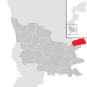
| Location of Bildein in the Güssing district | ||
  |
||
| Source: Municipal data from Statistics Austria | ||

Bildein ( Hungarian : Beled ) is a municipality in Burgenland in the Güssing district in Austria with 347 inhabitants (as of January 1, 2020), of which a good 4% belong to the Burgenland-Hungarian ethnic group.
geography
The community is located in southern Burgenland.
Community structure

The municipality includes the following two localities (population in brackets as of January 1, 2020):
- Oberbildein (181)
- Subpicture in (166)
The community consists of the cadastral communities Oberbildein and Unterbildein.
history
Like all of Burgenland, the place belonged to Hungary (German-West Hungary) until 1920/21 . Since 1898 had due to the Magyarization of the government in Budapest of Hungarian name Beled be used. The name Belyd is already attested in a letter of transfer from King Ludwig I to Wilhelm Ellerbach in 1369. After the end of the First World War, after tough negotiations, German-West Hungary was awarded to Austria in the Treaties of St. Germain and Trianon in 1919. The place has belonged de jure to the newly founded federal state of Burgenland since 1921 (see also the history of Burgenland ). Only after questioning by an Allied commission were Ober- and Unterbildein 1922 finally awarded to Austria.
In 1971 Oberbildein and Unterbildein were merged with the municipality of Eberau . While all other places remained near Eberau, Oberbildein and Unterbildein separated from Eberau again in 1993 and formed the new municipality of Bildein .
Population development

politics
Municipal council

The council comprises a total of 11 members based on the number of eligible voters.
| Political party | 2017 | 2012 | 2007 | 2002 | 1997 | ||||||||||
|---|---|---|---|---|---|---|---|---|---|---|---|---|---|---|---|
| Sti. | % | M. | Sti. | % | M. | Sti. | % | M. | Sti. | % | M. | Sti. | % | M. | |
| ÖVP | 256 | 79.26 | 9 | 269 | 76.20 | 9 | 229 | 72.24 | 8th | 227 | 70.06 | 8th | 239 | 78.36 | 9 |
| SPÖ | 67 | 20.74 | 2 | 84 | 23.80 | 2 | 88 | 27.76 | 3 | not running | 66 | 21.64 | 2 | ||
| SU A1 | not running | not running | not running | 94 | 29.01 | 3 | not running | ||||||||
| FPÖ | not running | not running | not running | 3 | 0.93 | 0 | not running | ||||||||
| Eligible voters | 359 | 390 | 342 | 348 | 353 | ||||||||||
| voter turnout | 93.04% | 92.82% | 94.74% | 94.25% | 90.08% | ||||||||||
mayor
Walter Temmel (ÖVP) has been mayor since the separation from Eberau on January 1st, 1993 . As in the previous elections, Temmel had no competitor in the direct mayor election on October 1, 2017 and was confirmed in his office by 75.96% of the voters.
Culture and sights


- Catholic parish church Bildein hl. Vitus
- In Bildein there is a museum with the Burgenland story (s) house , which has been presenting the history of Burgenland since 1921.
- A freely accessible labyrinth built in 2006 forms the first station on the Bildeiner Grenzerfahrungsweg .
Annual events
- Picture on festival
- a rock seminar
economy
Bildein is mainly agricultural and wine-growing.
literature
- Sandra Perl: Bildein. From the village on the border to the village without borders. Political and Social Life in the 20th Century. Diploma thesis, University of Vienna 2003.
- Eva Marion Windisch: Phonology and forms of the dialect of Unterbildein in southern Burgenland. Diploma thesis, University of Vienna 1996
Web links
- 10426 - Bildein. Community data, Statistics Austria .
- Community website
Individual evidence
- ↑ Statistics Austria: Population on January 1st, 2020 by locality (area status on January 1st, 2020) , ( CSV )
- ↑ a b Province of Burgenland: Election results Bildein 2017 (accessed on January 18, 2018)
- ↑ Province of Burgenland: Election results Bildein 2012 (accessed on January 18, 2018)
- ↑ Province of Burgenland: results of the Bildein 2007 election (accessed on January 18, 2018)
- ↑ a b Province of Burgenland: results of the Bildein 2002 election (accessed on January 18, 2018)
Picture in | Bocksdorf | Burgauberg-Neudauberg | Eberau | Gerersdorf-Sulz | Crabby | Güssing | Güttenbach | Hackerberg | Heiligenbrunn | Hay trench | Inzenhof | Mellow | Kukmirn | Mosque village | Neuberg im Burgenland | Neustift near Güssing | Olbendorf | Ollersdorf in Burgenland | Rauchwart | Rohr in Burgenland | Sankt Michael im Burgenland | Stegersbach | Stinatz | Strem | Tobaj | Tschanigraben | Mountain of words
Cadastral communities: Oberbildein | Subpicture
Locations: Oberbildein | Subpicture
Villages: Oberbildein | Unterbild in other locations: Bujahof
Counting district: Oberbildein | Subpicture