
Vik (Norway)
| coat of arms | map | ||
|---|---|---|---|

|
|
||
| Basic data | |||
| Commune number : | 4639 | ||
| Province (county) : | Vestland | ||
| Administrative headquarters: | Vikøyri | ||
| Coordinates : | 61 ° 3 ' N , 6 ° 35' E | ||
| Surface: | 833.23 km² | ||
| Residents: | 2,635 (Feb 27, 2020) | ||
| Population density : | 3 inhabitants per km² | ||
| Language form : | Nynorsk | ||
| Website: | |||
| politics | |||
| Mayor : | Roy Egil Stadheim ( Ap ) (2019) | ||
| Location in the province of Vestland | |||

|
|||

Vik (also called Vik i Sogn ) is a Norwegian town and municipality in the province of Vestland . It lies roughly in the middle of the Sognefjord on the south side and borders on Aurland to the east, Voss and Vaksdal to the south and Modalen and Høyanger to the west . On the other side of the fjord are Sogndal and Lærdal .
The municipality consists of five localities: Vikøyri is with 1085 inhabitants (2008) the largest place and administrative center of the municipality. Other localities are Arnafjord, Vangsnes, Fejos and Fresvik.
Attractions
- Hopperstad stave church , built around 1140
- Hove Church , built around 1150, the oldest stone building in Sogn og Fjordane
- Vikøyri, old day laborer settlement in the center of the village
- Fridtjovpark in Vangsnes. Here is the bronze statue of the Viking Fridtjov den Frøkne (the Brave) , a gift from Kaiser Wilhelm II to the Norwegians (1913). The park offers a breathtaking view of the Sognefjord .
- The Arnafjord , the idyllic arm of the Sognefjord with many waterfalls and good hiking opportunities. The fjord is about 20 km west of the center of Vikøyri.
- The Borgstova in Vik, built in 1864, is one of two buildings that are still preserved from the old officer's Sjøtun.
- The Finnafjord with the Finnabotn . To the west of the Arnafjord, the arm of the Sognefjord, at the mouth of which Hof is located. The steep valley walls create a special atmosphere as you approach the Finnabotn basin . The Finnafjord has no road connection and can only be reached by boat.
- Fresvikbreen in the Nærøyfjorden World Heritage Park . The Fresvikbreen glacier is located in the Nærøyfjorden nature reserve and world natural heritage park , one of the most spectacular fjord areas in the world. In 2005 it was added to the UNESCO World Heritage List .
- The Kristianhus Boat and Motor Museum includes a collection of around 200 mostly Norwegian ship and boat engines and shows the technological development from 1905 to 1960.
- The Moahaugane are a collection of burial mounds from the Roman period .
- Storesvingen. This lookout point with a café is located on the pass road from Vik to Voss .
- The Vikafjell and the conservation area Stølsheimen provide opportunities for hiking and skiing.
economy
Agriculture
Mainly milk production, lamb production and the cultivation of raspberries.
Industry
Energy production through hydropower. Viks hydropower plants produce around 900 gigawatt hours.
Equipment for road safety, steel or aluminum sheets, street signs, equipment for cold rooms and facade cladding.
The famous Gamalost cheese is made in a dairy in the center of the village .
tourism
The region around Vik is particularly popular with hikers and anglers.

View of Vikøyri

Boathouses in Vikoyri
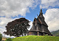
Hopperstad stave church

Barrows in Vik

Pass road over the Vikafjell

Pass road over the Vikafjell in spring


Individual evidence
- ↑ Statistisk sentralbyrå - Befolkning
- ↑ Store norske leksikon : Vikøyri . Retrieved April 9, 2011 (Norwegian)
Web links
Alver | Askful | Askøy | Aurland | Austevoll | Austrheim | Mountains | Bjørnafjorden | Bremanger | Bømlo | Eidfjord | Etne | Fedje | Fitjar | Fjaler | Glopping | Gulen | Hyllestad | Høyanger | Chin | Kvam | Kvinnherad | Chandelier | Lærdal | Masfjorden | Modals | Osterøy | Samnanger | Sogndal | Solund | City | Stord | Stryn | Sunnfjord | Sveio | Tysnes | Ullensvang | Ulvik | Vaksdal | Vik | Voss | Øygarden | Årdal