
Wülfershausen on the Saale
| coat of arms | Germany map | |
|---|---|---|

|
Coordinates: 50 ° 20 ' N , 10 ° 21' E |
|
| Basic data | ||
| State : | Bavaria | |
| Administrative region : | Lower Franconia | |
| County : | Rhön-Grabfeld | |
| Management Community : | Hall on the Saale | |
| Height : | 266 m above sea level NHN | |
| Area : | 18.13 km 2 | |
| Residents: | 1472 (Dec. 31, 2019) | |
| Population density : | 81 inhabitants per km 2 | |
| Postal code : | 97618 | |
| Area code : | 09762 | |
| License plate : | NES, CAN, MET | |
| Community key : | 09 6 73 184 | |
| Community structure: | 5 districts | |
| Association administration address: | Wiesenflecklein 4 97633 Saal adSaale |
|
| Website : | ||
| Mayor : | Wolfgang Seifert | |
| Location of the community of Wülfershausen an der Saale in the Rhön-Grabfeld district | ||
  |
||


Wülfershausen an der Saale (officially: Wülfershausen adSaale ) is a municipality in the Lower Franconian district of Rhön-Grabfeld and a member of the Saal an der Saale administrative community .
geography
Wülfershausen an der Saale is located in the Main-Rhön region in the center of Grabfeld, on the Franconian Saale .
Community structure
Wülfershausen an der Saale is divided into five districts:
- Eichenhausen
- Foundling mill
- Castle mill
- Taubachsmühle
- Wülfershausen on the Saale
There are the districts Eichenhausen and Wülfershausen an der Saale.
history
Until the church is planted
In the year 800 the first documentary mention took place in a deed of donation of the pious Amalbirge, daughter of the nobleman, who in the year 32 of the government of Charles (800 AD) in "Munrichstat" all her belongings, including those in "Villa Wulfrichshus" in Gau Grabfeld bequeathed the Salvatordom in Würzburg.
Further documentary information contains the Fuldar traditions , according to which in 801 the same nobleman bequeathed all his possessions in Wulferichshus to the Fulda monastery .
During the time of the tribal duchies , the place was in the Duchy of Franconia .
In 1018, Bishop Heinrich I of Würzburg gave the tithe from Wülfershausen to the Benedictine monastery of St. Stephan in Würzburg, which he founded . In 1136 this monastery in Wülfershausen acquired its own farm, which over the centuries developed into the largest farm in the village through donations and purchases.
On January 4th, 1258, Prince-Bishop Iringus von Rheinstein bequeathed the entire village of Wülfershausen to the St. Stephan monastery in Würzburg. From then on, Wülfershausen was “subject to tenancy and validity” for the monastery in the following centuries.
From the incorporation letter from the parish of Wülfershausen to the St. Stephen's monastery in Würzburg, it can be seen that Benedictine fathers took over pastoral care there and in four neighboring subsidiary villages up to secularization in 1804. The Benedictines shaped the townscape and the people of Wülfershausen structurally and socially in the following centuries. In addition to their construction activities, they also cultivated viticulture in Wülfershausen, which was very popular until 1840.
Around 1500 Wülfershausen received the privilege of holding three markets (Kehlmärkte) within its walls. The market flag attached to the town hall announced the duration of the market.
At that time, the right of attachment was connected with the market law. In ancient times the village was protected from enemies to the south and west by the Saale and north and east by a rampart and a wall. In the area of the church and parsonage there was a fortified church with the so-called Gaden . The last Gaden fell victim to the pickaxe when the church was being built in 1962/63.
The municipal archive testifies that Wülfershausen once had three gate towers and gatehouses in addition to significant reinforcement: the upper gate, the lower gate and the Angertor. The Untertor was razed in 1790, the Obertor in 1832 and the Angertor in 1837. Even today local areas are named after these gate names.
In 1607, catastrophic fires destroyed a total of 97 apartments and barns, and in 1692 113 buildings were reduced to rubble.
In 1804 Wülfershausen, which previously belonged to the Bad Neustadt an der Saale regional court, was assigned to the Bad Königshofen regional court and rent office.
In 1829 Anna-Maria Rösch donated an early measurement benefit.
In 1840 the once widespread viticulture (storage of 82 hectoliters in the tithe cellar under the rectory in 1683) was discontinued in Wülfershausen. The town's coat of arms and the St. Urban procession - Saint Urban is the patron saint of the vineyards - remind of this every year on May 25th.
The office of the Hochstift Würzburg belonged to the Franconian Empire from 1500 . It was after the secularization in 1803 in favor of Bavaria in 1805 Archduke Ferdinand of Tuscany to form the Grand Duchy left and fell with this 1814 final to Bayern. In 1818 the political municipality was established.
The sunken place Veitschwingen
Beneficiary Georg Schwinger mentioned in his village chronicle from 1898 the place Veitschwingen (or Veitswinden), which is said to have been northwest of the White Tower. According to the legend passed down orally in Wülfershausen, a girl (four people elsewhere) attended the Kirchweihtanz in Wülfershausen and couldn't find the place on his return, he was lost. The beneficiary cited as evidence that Wülfershausen had previously provided two lay judges (which can also be explained by the two halves of the village belonging to the two monasteries). Furthermore, a bell from Veitschwingen is said to have struck the quarter of an hour for a long time.
The truth of the tradition cannot be verified. However, in the Main Franconian study no. 1, the desolate places Brunigsdorf, Haelßhausen (also Holzhausen) and Veitswinden in the Wülfershausen district are named. Veitschwingen is mentioned several times, it was obviously already fallen in the first half of the 15th century. Beneficiary Schwinger cites the stand book 358 , according to which the deserted Veitswinden was bequeathed to farmers in Wargolshausen by Abbot Kilian from Bildhausen in 1515 .
Jewish life

Jewish families had lived in the district of Eichenhausen since at least the 19th century and built their synagogue at Ortsstrasse 37 . This place of worship was destroyed by SA men during the November pogrom in 1938 , as a reminder plaque on the war memorial.
Incorporations
On May 1, 1978, as part of the regional reform, the previously independent municipality of Eichenhausen was incorporated.
Population development

Buildings
Architectural monuments
St. Stephen Chapel
The Romanesque / late Gothic St. Stephan cemetery chapel, popularly known as the “Stöffskirch”, is located on a slight hill near the federal road 279 , surrounded by the cemetery. Before 1607, the old cemetery was around the very first parish church of St. Vitus and within the protective fortified church in the village. Since this burial place had become too narrow due to the growing population, arable land was given away from the old monastery property for the new cemetery in 1507.
A small St. Stephen's chapel, probably from the 13th century, already stood on this property.
In 1507 the chapel was enlarged by a nave (builder unknown). It can be assumed that the monastery carried out the expansion of the chapel, especially since the building stands on the Stephanshofgut, which was owned by the monastery. The estate was later sold with the stipulation that the new owner had to ring the prayer ("Angelus") every day.
The stations of the cross within the two meter high wall of the cemetery, donated by a “benefactor”, were erected and inaugurated in 1863. They document the craftsmanship of an ingenious but unknown master stonemason.
The Lourdes grotto on the eastern wall of the chapel, also a foundation, dates from 1896 and is still very often a place of refuge today.
In the district of Anger near the St. Stephen's Chapel, no buildings from the 13th century have survived, but some houses have survived two to three hundred years. Individual half-timbered houses with richly carved beams, corner posts, wood tooth cut decorations and with the daisy as the center of the curved St. Andrew's crosses show the craftsmanship and wealth of their former owners.

Stephanus chapel with Lourdes grotto

Lourdes grotto

Inside view of St. Stephen's Chapel

Old sacrificial stock in the Stephanus chapel
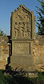
10. Station of the cross at the cemetery of Wülfershausen an der Saale
Close-up view of the 10th station of the cross at the cemetery in Wülfershausen an der Saale

Detail of the nail basket, 10th station of the cross at the cemetery of Wülfershausen an der Saale

13. Station of the Cross at the cemetery of Wülfershausen an der Saale


Town hall and Schlundhaus


On the way to the church to the north is the old high town hall with the arched console entrance. It testifies to the then exercised right to own administration and lower jurisdiction and shows the Franconian coat of arms with the year 1584 on its south side.
Next to it, the former community gullet has been rising since 1613, which later became the Ziegler restaurant. It was one of three community farms at the time.
Rectory and tithe barn
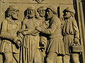
To the north-east of this is the rectory with the mighty tithe barn and the elongated rectory with its Renaissance entrance decorated with figures and coats of arms. It was built in 1608 by Father Kilian Gullmann, the local pastor at the time, as an apartment for several fathers and friars to look after the neighboring parishes, after having had a new church built the year before, in 1607. The nearby Zehntscheuer, called Herrenbau, was built in the same year. It was the collection point for tithes, guilds and kingdoms in Wülfershausen and six other localities in the vicinity.
Parish Church of St. Vitus

To the east of the rectory stands the new parish church of St. Vitus , built in 1962/63 by the church architect Erwin van Aaken . It is a simple, modern one-room sacred building made of concrete and glass, which replaced the old church that had become too small and was built by Father Gullmann in 1607. At that time the lower half of the tower ( Julius-Echter-Turm ) was preserved. In 1962/63, when the new church was built, the entire tower was left with its dimensions. The church was built under Pastor Geis, the debt relief under Pastor Hugo Müller, who was in charge of the pastoral position in Wülfershausen for over 30 years.
school

South of the parish church is the schoolhouse built in 1902 in ashlar masonry, the stones of which come from the municipality's own quarries. It replaced the old schoolhouse from 1790, which had been built with stones from the lower gate, which was demolished in the same year, and which had taken the place of the dilapidated, old schoolhouse. The first schoolmaster to be appointed according to the certificate was Kaspar Neugast in 1575. Around 1600 Sebastian Fügespan, who was also a publicly appointed notary, was named. In 1902, the Baumbach company from Nordheim vd Rhön acted as master builder for the new school and received 42,000 Reichsmarks for the construction costs. The school building has five school halls and is still used today as a primary school in the Saale Valley School Association.
White Tower

In 1617 the watch tower on the Landwehr on the eastern boundary of the district was painted white according to the municipality's accounts. Since then, the landscape-defining tower on the corridor border to Waltershausen and Wargolshausen has been called the White Tower . The previous building may have been a wooden tower from the 13th century, which was used to detect enemy attacks in good time and to alert the population. A restaurant in the new building area in Wülfershausen is called the Gasthaus Zum Weißen Turm.
Rococo canes


On the way to the Franconian Saale, which leads through a chestnut avenue with a view to the east over the meadow, there are rococo wayside shrines like the “Savior on the Scourge Column”, “the processional altar with the Last Supper” (a foundation) and the “Holy St. Nepomuk” “On the Saale bridge, all signs of the Benedictine monks who used to work in the village.
War memorial and festival of the poor souls
The war memorial, recently redesigned, is located under tall trees above the valley floor. With the Baroque Madonna by the sculptor Franz Weigand from Oberelsbach, the foundation commemorates those who died in the Franco-Prussian War of 1870/71 and the two world wars. Every year in July, Wülfershausen remembers his dead and fallen at the Poor Souls Festival. The Armenseelenfest is a foundation of the siblings Gertrud and Marianne Weber from 1920.
On the opposite side of the Breiten Saale - the former Mühlbach no longer exists since the communal Angermühle was sold - there are further properties with courtyard gates, residential houses with curtain-arched, Gothic pedestrian gates.
politics
Municipal council
After the mayoral election in 2018, the municipal council has 13 members, 7 for the CSU, 6 seats for the Free Voters Wülfershausen-Eichenhausen.
mayor
Mayor is Wolfgang Seifert, who succeeded Peter Schön on January 23, 2018. Peter Schön resigned in October 2017. On January 21, 2018, the CSU candidate Wolfgang Seifert was elected mayor of the Saale municipality with over 60% of the votes against his competitor Heiko Sterzinger.
coat of arms
In 1575 Wülfershausen received a municipal coat of arms from Prince-Bishop Julius Echter . It shows the parish patron saint, Saint Vitus, and Echter's coat of arms. The original coat of arms can be found in the municipal archive.
Economy and Infrastructure
Economy including agriculture and forestry
In 2017, according to official statistics, there were 240 employees subject to social insurance contributions at the place of work and 632 employees subject to social insurance contributions at home, so that 392 more people commuted than commuted. In 2016 there were 18 farms; the area used was 628 ha of arable land and 119 ha of permanent green space.
education
There are the following institutions (as of 2018):
- Kindergartens: 85 kindergarten places with 63 children
Web links
- Entry on the coat of arms of Wülfershausen an der Saale in the database of the House of Bavarian History
Individual evidence
- ↑ "Data 2" sheet, Statistical Report A1200C 202041 Population of the municipalities, districts and administrative districts 1st quarter 2020 (population based on the 2011 census) ( help ).
- ↑ bayerische-landesbibliothek-online.de
- ↑ Veitschwingen in Bavaria Atlas
- ↑ a b history of the parish Wülfershausen with its branch, Benefiziat Georg Schwinger, 1898th
- ↑ a b Reinhold E. Lob: The desolations of the Bavarian Rhön and the north-western grave field. (= Main Franconian Studies. 1). Würzburg 1971.
- ↑ Memorial sites for the victims of National Socialism. A documentation. Volume 1, Federal Agency for Civic Education, Bonn 1995, ISBN 3-89331-208-0 , p. 198 f.
- ^ Federal Statistical Office (ed.): Historical municipality directory for the Federal Republic of Germany. Name, border and key number changes in municipalities, counties and administrative districts from May 27, 1970 to December 31, 1982 . W. Kohlhammer, Stuttgart / Mainz 1983, ISBN 3-17-003263-1 , p. 741 .

Aubstadt | Bad Königshofen im Grabfeld | Bad Neustadt an der Saale | Bastheim | Bischofsheim in the Rhön | Burglauer | Fladungen | Großbardorf | Großeibstadt | Hausen | Hendungen | Herbstadt | Haystack | Höchheim | Hohenroth | Hollstadt | Mellrichstadt | Niederlauer | Nordheim before the Rhön | Oberelsbach | Top litter | Ostheim before the Rhön | Rödelmaier | Hall on the Saale | Salt | Sandberg | Schönau an der Brend | Sondheim before the Rhön | Stockheim | Radiations | Sulzdorf an der Lederhecke | Sulzfeld | Trappstadt | Unsleben | Willmars | Wollbach | Wülfershausen on the Saale
Unregulated areas in the district of Rhön-Grabfeld Bundorfer Forst |
Burgwallbach Forest |
Forest Schmalwasser-Nord |
Forest Schmalwasser-Süd |
Mellrichstadter Forest |
Steinacher Forest on the right of the Saale |
Sulzfelder Forest |
Weigler