
Sülysáp: Difference between revisions
m Updated with 2009 figures from KSH |
it's to the east, look at the map |
||
| (44 intermediate revisions by 26 users not shown) | |||
| Line 1: | Line 1: | ||
| ⚫ | |||
{{Refimprove|date=September 2009}} |
|||
<!-- General information --> |
|||
|official_name =Sülysáp |
|||
| ⚫ | |||
| |
|image_shield = HUN Sülysáp Címer.svg |
||
|image_flag = Flag of Sülysáp.svg |
|||
| image_skyline = |
|||
|image_skyline = Sülysáp, tápiósápi római katolikus templom 2021 01.jpg |
|||
| image_flag = HUN_Sülysáp_COA.jpg<!-- http://upload.wikimedia.org/wikipedia/hu/1/1e/S%C3%BClys%C3%A1p_c%C3%ADmere.jpg --> |
|||
|image_caption = Church of Saint Stephen of Hungary |
|||
| image_seal = |
|||
<!-- Pushpin map --> |
|||
| ⚫ | |||
| |
|pushpin_map =Hungary |
||
|pushpin_map_caption =Location of Sülysáp in Hungary |
|||
| ⚫ | |||
<!-- Political information --> |
|||
| ⚫ | |||
|subdivision_type =Country |
|||
| ⚫ | |||
|subdivision_name =[[Hungary]] |
|||
|subdivision_type1 =[[List of regions of Hungary|Region]] |
|||
|subdivision_name1 =[[{{Hungarian county region|Pest}}]] |
|||
|subdivision_type2 =[[Counties of Hungary|County]] |
|||
|subdivision_name2 ={{Hungarian county link|Pest}} |
|||
|subdivision_type3 =[[Districts of Hungary|District]] |
|||
| ⚫ | |||
|subdivision_type5 =[[List of Roman Catholic dioceses in Hungary|Diocese]] [[Roman Catholicism in Hungary|(RC)]] |
|||
| ⚫ | |||
|leader_title =Mayor |
|||
| ⚫ | |||
|url=http://www.szeporszag.hu/main.php?ds_clock_delta=0&language=english&ds_show=reszletez&ds_noback=yes&modify=501 |
|url=http://www.szeporszag.hu/main.php?ds_clock_delta=0&language=english&ds_show=reszletez&ds_noback=yes&modify=501 |
||
|language=English |
|language=English, Hungarian, German, French, Spanish, Italian, Slovak, Polish |
||
|accessdate=2009-09-15 |
|accessdate=2009-09-15 |
||
|title= |
|title=Sülysáp település oldala |
||
}}</ref> |
}}</ref> |
||
<!-- Geographical information --> |
|||
| area_magnitude = 1 E7 |
|||
| |
|area_total_km2 =47.19 |
||
|area_footnotes =<ref name="ksh_cite_area">[http://www.ksh.hu/apps/!cp.hnt2.telep?nn=21713 Sülysáp] at the [[Hungarian Central Statistical Office]] (Hungarian).</ref> |
|||
| ⚫ | |||
|coordinates ={{coord|47.452|N|19.534|E|region:HU|display=inline}} |
|||
| ⚫ | |||
<!-- Demographical information --> |
|||
| population_total = 8258 |
|||
| |
|postal_code =2241 |
||
| |
|postal_code_type =[[Postal code]] |
||
| |
|area_code =+36 29 |
||
|area_code_type =[[Telephone numbers in Hungary|Area code]] |
|||
| ⚫ | |||
| |
|timezone =[[Central European Time|CET]] |
||
|utc_offset =+1 |
|||
|timezone_DST =[[Central European Summer Time|CEST]] |
|||
| elevation_m = |
|||
| ⚫ | |||
| elevation_min_m = |
|||
| ⚫ | |||
| elevation_max_m = |
|||
| |
|population_total =8258 |
||
|population_density_km2 =auto |
|||
| footnotes = |
|||
|population_density_urban_km2 =auto |
|||
}} |
|||
|population_density_metro_km2 =auto |
|||
| ⚫ | |||
| ⚫ | |||
|blank_info = |
|||
<!-- From Hungarian infobox : |
|||
|website =[http://www.sulysap.hu www.sulysap.hu] |
|||
| név = Sülysáp |
|||
| címer = Sülysáp_címere.jpg |
|||
| régió = Közép-Magyarország |
|||
| megye = Pest |
|||
| kistérség = Nagykátai |
|||
| rang = [[nagyközség]] |
|||
| irányítószám = 2241 |
|||
| körzethívószám = 29 |
|||
| népsűrűség = 174,87 |
|||
| terület = 47,33 |
|||
| szélességi fok = 47.45212 |
|||
| hosszúsági fok = 19.53386 |
|||
| weboldal = www.sulysap.hu |
|||
}} |
}} |
||
--> |
|||
'''Sülysáp''' is a |
'''Sülysáp''' is a town in [[Pest County]], [[Hungary]] about {{convert|40|km}} east of [[Budapest]]. In 1950 two villages, [[Tápiósáp]] and [[Tápiósüly]], amalgamated, but they separated in 1954. In 1970 they combined again to form Sülysáp. |
||
==Geography== |
==Geography== |
||
Sülysáp is in the Lower [[Tápió]] Valley of the [[ |
Sülysáp is in the Lower [[Tápió]] Valley of the [[Gödöllő|Gödöllő hills]]. In this picturesque location, surrounded by beautiful low hills and good terrain, the Lower [[Tápió]] and [[Sápi]] streams add to making the town a beauty spot. |
||
<!-- From hu.wikipedia.org: (Monika (or other!): As you translate this, delete from the Hungarian or leave in comments they start with <!-- and end with --> |
|||
==Communications== |
==Communications== |
||
Primary route 31 serves the |
Primary route 31 serves the town by road. |
||
Express and stopping trains of the [[Hungarian State Railways]] serve the |
Express and stopping trains of the [[Hungarian State Railways]] serve the town on [[Regional rail|suburban]] line 120a ([[Budapest]]–[[Újszász]]–[[Szolnok]]) at the main station (Sülysáp) and a smaller station halt ([[Szőlősnyaralö]]). "Szőlősnyaralö" is best translated as "Vineyard retreat"; the village was built as holiday homes for workers from Budapest. Over the years these holiday homes have been converted and extended and are used as main homes. |
||
The nearest airport is the main international airport for the capital, [[Budapest International Airport|Budapest-Ferihegy]]. |
The nearest airport is the main international airport for the capital, [[Budapest International Airport|Budapest-Ferihegy]]. |
||
==Economy== |
==Economy== |
||
There are around 360 [[small and medium enterprise]]s in the |
There are around 360 [[small and medium enterprise]]s in the town, providing the livelihood of a large segment of the population. |
||
After the collapse of the [[collective farming]] system, the lands around Sülysáp were [[privatized]], and farmers became [[self-employment|self-employed]]. The Agricultural Service [[Agricultural co-operative|Co-op]] was founded not long after, and currently [[leasing|leases]] almost half of the land from the owners, with a large number of members. |
After the collapse of the [[collective farming]] system, the lands around Sülysáp were [[privatized]], and farmers became [[self-employment|self-employed]]. The Agricultural Service [[Agricultural co-operative|Co-op]] was founded not long after, and currently [[leasing|leases]] almost half of the land from the owners, with a large number of members. |
||
| Line 89: | Line 89: | ||
==Gallery== |
==Gallery== |
||
<gallery class="center" mode="packed" heights="165"> |
|||
| ⚫ | |||
File:Móra Ferenc Általános Iskola Sülysáp.jpg|alt=Photograph of Ferenc Móra Primary School|[[Ferenc Móra]] Primary School |
|||
File:Sulysap all.jpg|alt=Photograph of Sülysáp railway station|Sülysáp railway station in May 2007 |
|||
File:Sülysáp station ("allomas") from the same angle as the existing image on WikiMedia Commons.JPG|alt=From the same angle as the previous photograph, six years later. The [[MÁV]] branding has been removed from the station building. New trains built by Siemens now run along line 120a, the photograph shows one awaiting to depart its return run to Budapest.|The station in February 2014. A Budapest-bound train is ready to depart |
|||
}} |
|||
| ⚫ | |||
==Twin towns - twin cities== |
|||
* {{flagicon|AUT}} [[Innsbruck]] – [[Austria]] |
|||
* {{flagicon|UK}} [[Plymouth]] – [[United Kingdom]] |
|||
* {{flagicon|ROU}} [[Sânmartin, Harghita|Sânmartin]] – [[Romania]] |
|||
==References== |
==References== |
||
| Line 98: | Line 104: | ||
==External links== |
==External links== |
||
* [http://www.vendegvaro.hu/5-2462 vendegaron.hu] Sülysáp at portal "Vendégvárón" |
* [http://www.vendegvaro.hu/5-2462 vendegaron.hu] Sülysáp at portal "Vendégvárón" {{in lang|hu}} |
||
* [http://sulysap.lap.hu/ Sülysáp.lap.hu] Sülysáp at portal "Starlap" |
* [http://sulysap.lap.hu/ Sülysáp.lap.hu] Sülysáp at portal "Starlap" {{in lang|hu}} |
||
* [http://www.1hungary.com/info/sulysap/ 1hungary.com] Sülysáp information at 1hungary.com |
* [http://www.1hungary.com/info/sulysap/ 1hungary.com] Sülysáp information at 1hungary.com {{in lang|en}} |
||
* [http://nagyvofely.hu/sulysap-tapiosuly/templomok nagyvodely.hu] Churches in Sülysáp |
* [http://nagyvofely.hu/sulysap-tapiosuly/templomok nagyvodely.hu] Churches in Sülysáp {{in lang|hu}} |
||
* |
|||
{{Nagykáta District}} |
|||
<!-- {{hu:csonk-dátum|Pest census|November 2005}} (in Hungarian) --> |
|||
| ⚫ | |||
{{authority control}} |
|||
{{DEFAULTSORT:Sulysap}} |
{{DEFAULTSORT:Sulysap}} |
||
[[Category: |
[[Category:Populated places in Pest County]] |
||
[[Category:Grassalkovich family]] |
[[Category:Grassalkovich family]] |
||
| ⚫ | |||
[[eo:Sülysáp]] |
|||
[[it:Sülysáp]] |
|||
[[hu:Sülysáp]] |
|||
[[nl:Sülysáp]] |
|||
[[sk:Sülysáp]] |
|||
Latest revision as of 02:22, 2 January 2024
Sülysáp | |
|---|---|
 Church of Saint Stephen of Hungary | |
 Flag  Coat of arms | |
 Sülysáp Location of Sülysáp in Hungary | |
| Coordinates: 47°27′07″N 19°32′02″E / 47.452°N 19.534°E | |
| Country | Hungary |
| Region | Central Hungary |
| County | Pest |
| District | Nagykáta |
| Diocese (RC) | Vác |
| Government | |
| • Mayor | László Horinka[1] |
| Area | |
| • Total | 47.19 km2 (18.22 sq mi) |
| Population (1 January 2009)[3] | |
| • Total | 8,258 |
| • Density | 170/km2 (450/sq mi) |
| Time zone | UTC+1 (CET) |
| • Summer (DST) | UTC+2 (CEST) |
| Postal code | 2241 |
| Area code | +36 29 |
| Website | www.sulysap.hu |
Sülysáp is a town in Pest County, Hungary about 40 kilometres (25 mi) east of Budapest. In 1950 two villages, Tápiósáp and Tápiósüly, amalgamated, but they separated in 1954. In 1970 they combined again to form Sülysáp.
Geography[edit]
Sülysáp is in the Lower Tápió Valley of the Gödöllő hills. In this picturesque location, surrounded by beautiful low hills and good terrain, the Lower Tápió and Sápi streams add to making the town a beauty spot.
Communications[edit]
Primary route 31 serves the town by road.
Express and stopping trains of the Hungarian State Railways serve the town on suburban line 120a (Budapest–Újszász–Szolnok) at the main station (Sülysáp) and a smaller station halt (Szőlősnyaralö). "Szőlősnyaralö" is best translated as "Vineyard retreat"; the village was built as holiday homes for workers from Budapest. Over the years these holiday homes have been converted and extended and are used as main homes.
The nearest airport is the main international airport for the capital, Budapest-Ferihegy.
Economy[edit]
There are around 360 small and medium enterprises in the town, providing the livelihood of a large segment of the population.
After the collapse of the collective farming system, the lands around Sülysáp were privatized, and farmers became self-employed. The Agricultural Service Co-op was founded not long after, and currently leases almost half of the land from the owners, with a large number of members.
Other companies employing significant numbers of people include Ebm. Hungary Ltd., Jász-Plasztik Ltd., Darázs Ltd., and Fővárosi Gázmúvek (Budapest Gas Works Co) Public Company. Local government services also employ many people.
Landmarks[edit]
- The Roman Catholic Church of Our Lady, built in 1489 in Gothic style.
- The Sőtér Castle, built by the Sőtér family of landed gentry in 1725.
- The Grassalkovich shooting lodge, visited by Sándor Petőfi during the Hungarian Revolution of 1848.
- The life-size statue of Saint Stephen on Saint Stephen Square.
- The statue of the Holy Trinity.
- The statue of Saint John of Nepomuk.
- The House of Prayer of the Pentecostal Church.
- The Italian memorial by the Fiume Studies Society, in remembrance of the 129 Italian citizens who died at Tápiósüly (now part of Sülysap) in the internment camp.[4]
- The statue of a girl holding a peacock.
Gallery[edit]
-
 Ferenc Móra Primary School
 -
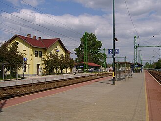 Sülysáp railway station in May 2007
 -
 The station in February 2014. A Budapest-bound train is ready to depart


_from_the_same_angle_as_the_existing_image_on_WikiMedia_Commons.JPG)
Twin towns - twin cities[edit]
References[edit]
- ^ "Sülysáp település oldala" (in English, Hungarian, German, French, Spanish, Italian, Slovak, and Polish). Retrieved 2009-09-15.
- ^ Sülysáp at the Hungarian Central Statistical Office (Hungarian).
- ^ Sülysáp at the Hungarian Central Statistical Office (Hungarian). 1 January 2009
- ^ "Olasz-emlekmu" (in Hungarian). Vendégváró. Retrieved 15 September 2009.
External links[edit]
- vendegaron.hu Sülysáp at portal "Vendégvárón" (in Hungarian)
- Sülysáp.lap.hu Sülysáp at portal "Starlap" (in Hungarian)
- 1hungary.com Sülysáp information at 1hungary.com (in English)
- nagyvodely.hu Churches in Sülysáp (in Hungarian)
| Towns (3) |
| |
|---|---|---|
| Large villages (2) | ||
| Villages (10) | ||


| International | |
|---|---|
| National | |