Langenau: Difference between revisions
Content deleted Content added
m Date maintenance tags and general fixes using AWB |
added photo |
||
| Line 2: | Line 2: | ||
|Art = Stadt |
|Art = Stadt |
||
|Name = Langenau |
|Name = Langenau |
||
|image_photo = |
|image_photo = Langenau Bahnhof 080208 IMG 0354.JPG |
||
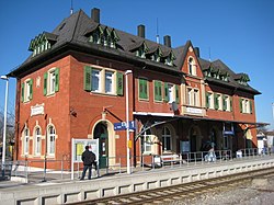
|image_caption = Train station |
|||
|Wappen = Wappen Langenau (Wuerttemberg) .png |
|Wappen = Wappen Langenau (Wuerttemberg) .png |
||
|lat_deg = 48 |lat_min = 29 |lat_sec = 48 |
|lat_deg = 48 |lat_min = 29 |lat_sec = 48 |
||
Revision as of 21:44, 8 December 2008
Langenau | |
|---|---|
 Train station | |
| Country | Germany |
| State | Baden-Württemberg |
| Admin. region | Tübingen |
| District | Alb-Donau-Kreis |
| Government | |
| • Mayor | Wolfgang Mangold |
| Area | |
| • Total | 75.00 km2 (28.96 sq mi) |
| Elevation | 458 m (1,503 ft) |
| Population (2022-12-31)[1] | |
| • Total | 15,633 |
| • Density | 210/km2 (540/sq mi) |
| Time zone | UTC+01:00 (CET) |
| • Summer (DST) | UTC+02:00 (CEST) |
| Postal codes | 89129 |
| Dialling codes | 07345 |
| Vehicle registration | UL |
| Website | www.langenau.de |
Langenau is a town in the district of Alb-Donau in Baden-Württemberg in Germany. It is situated 14 km northeast of Ulm.
- ^ "Bevölkerung nach Nationalität und Geschlecht am 31. Dezember 2022" [Population by nationality and sex as of December 31, 2022] (CSV) (in German). Statistisches Landesamt Baden-Württemberg. June 2023.


