
Freeway

A freeway — also known as a highway, superhighway, autoroute, autobahn, autopista, autovía, autostrada, dual carriageway, expressway, or motorway — is a type of road designed for safer high-speed operation of motor vehicles through the elimination of at-grade intersections. This is accomplished by preventing access to and from adjacent properties and eliminating all cross traffic through the use of grade separations and interchanges; railroad crossings are also removed. Such highways are usually divided with at least two lanes in each direction. Because traffic never crosses at-grade, there are generally no traffic lights or stop signs.
The word "freeway" first surfaced in the mid-1930s in proposals for the improvement of the New York City parkway network.[1] It is currently in regular use in the United States as well as parts of Canada and Australia. Other countries refer to a freeway as a grade-separated highway[citation needed] or a superhighway[citation needed]. In the United States the term "freeway" is frequently used in the western part of the country. Other terms are predominant in other regions, such as "interstate" in the South (and particularly in Florida) and "highway", "expressway", or "turnpike" in the Northeast and Midwest. While some people use these terms interchangeably, "turnpikes" and "thruways" have specific associations with some toll roads and other limited access highways such as the Pennsylvania Turnpike, West Virginia Turnpike, New Jersey Turnpike, Florida's Turnpike, and New York State Thruway.[citation needed]
General characteristics

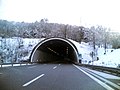
Freeways, by definition, have no cross traffic in the form of other roads, railroads or multi-use trails. Elimination of cross traffic is typically achieved with grade separation in the form of underpasses and overpasses. In addition to sidewalks (footpaths) attached to roads that cross a freeway, specialized pedestrian bridges or tunnels may also be provided. These structures enable pedestrians and cyclists to cross the freeway without a long detour to the nearest motor vehicle crossing. Movable bridges (such as drawbridges) are occasionally present on freeways which require drivers to yield to river traffic, such as the Interstate Bridge on I-5 between Oregon and Washington. However, not all roads bearing the name of freeway are in fact freeways by definition; for example, the William L. Wilson Freeway (U.S. Route 340) by Harpers Ferry, West Virginia, is designated as being a freeway, although it is a two-lane undivided roadway featuring at-grade intersections.
Access is typically provided only at interchanges; though lower-standard right-in/right-out access can be used for direct connections to side roads. In many cases, sophisticated interchanges allow for smooth, uninterrupted transitions between intersecting freeways and busy arterial roads. However, sometimes it is necessary to exit onto a surface road to transfer from one freeway to another. An example of this would be Interstate 70 in the town of Breezewood, Pennsylvania.[2]

Two-lane freeways, often undivided, are sometimes built when traffic volumes are low or right-of-way is limited; they may be designed for easy conversion to one side of a four-lane freeway. Otherwise, freeways typically have at least two lanes in each direction; some busy ones can have as many as 16[3] or more lanes.[4] These wide freeways may use separate collector and express lanes to separate through traffic from local traffic, or special high-occupancy vehicle lanes, either as a special restriction on the innermost lane or a separate roadway, to encourage carpooling. These HOV lanes, or roadways open to all traffic, can be reversible lanes, providing more capacity in the direction of heavy traffic, and reversing direction before traffic switches. Sometimes a collector/distributor road, a shorter version of a local lane, shifts weaving between closely-spaced interchanges to a separate roadway or altogether eliminates it.

Freeways can have frontage roads, normal surface roads parallel to and on either side of the freeway, to provide access to adjacent properties. Frontage roads typically have one-way traffic flow in urban areas and two-way traffic flow in rural areas.[citation needed] Slip ramps at regularly-spaced intervals allow access between the freeway and adjacent frontage road.[citation needed]
Except on some two-lane freeways (and very rarely on wider freeways), a median separates the opposite directions of traffic. This strip may be as simple as a grassy area, or may include a crash barrier such as a "Jersey barrier" or a "Ontario Tall Wall"" to prevent head-on collisions.[5] On some freeways, the two carriageways are built on different alignments; this may be done to make use of available corridors in a mountainous area or to provide narrower corridors through dense urban areas.[citation needed]


Speed limits are generally higher on freeways, and occasionally are nonexistent (for instance on several German Autobahns). Because higher speeds reduce decision time,[citation needed] freeways are usually equipped with a larger number of guide signs than other roads, and the signs themselves are physically larger. Guide signs are often mounted on overpasses or overhead gantries so that drivers can see where each lane goes. Exit numbers are commonly derived from the exit's distance in miles or kilometers from the start of the freeway.
In some areas, there are public rest areas or service areas on freeways, as well as emergency phones on the shoulder at regular intervals.[citation needed]
In the United States, mileposts start at the southern or westernmost point on the freeway (either its terminus or the state line). California, Ohio, and Nevada uses a postmile system where markers indicate mileage through the state's individual counties, however Nevada and Ohio also use the standard milepost system concurrently with their respective postmile systems on freeways only. Until the 1980s, New York used reference markers which, like California, indicated mileage through individual counties. The New York State Department of Transportation has since supplemented their reference marker system with mileposts indicating a freeway's mileage through the state.[citation needed]
Access restrictions

To reduce the probability that high-speed freeway traffic will have to slow down for slower same-direction traffic, access to freeways is usually limited to classes of motor vehicles that are powerful enough to maintain a certain minimum speed. Some East Asian countries partially restrict the use of motorcycles or ban them completely from freeways (or expressways in countries where that term is used) (see restrictions on motorcycle use on freeways).
In many areas, travelers using low-powered modes of transportation (such as pedestrians, bicyclists, equestrians, and moped drivers) are banned at all times from freeways by default. These users are allowed on freeways in some jurisdictions, usually where freeways too often replaced (rather than supplemented) existing roads (see non-motorized vehicle access on freeways).
Legal definitions
United States
In the United States, a freeway is defined by the federal government’s Manual on Uniform Traffic Control Devices as a divided highway with full control of access.[6] This means two things. First, adjoining property owners do not have a legal right of access, meaning that they cannot connect their lands to the highway by constructing driveways, although frontage roads provide access to properties adjacent to a freeway in many places.[7] When an existing road is converted into a freeway, all existing driveways must be removed and access to adjacent private lands must be blocked with fences or walls. Second, traffic on the highway is "free-flowing", although many non-engineers misinterpret the "free" in "freeway" to mean that such a highway must be free of charge to use. All cross-traffic (and left-turning traffic) has been relegated to overpasses or underpasses, so that there are no traffic conflicts on the main line of the highway which must be regulated by a traffic light, stop signs, or other traffic control devices. Achieving such free flow requires the construction of many bridges, tunnels, and ramp systems. The advantage of grade-separated interchanges is that freeway drivers can almost always maintain their speed at junctions since they do not need to yield to crossing traffic.
In contrast, an expressway is defined as a divided highway with partial control of access.[8] Expressways may have driveways and at-grade intersections, though these are usually less numerous than on ordinary arterial roads. Some states prefer to use the term "expressway" for what the federal government calls "freeways"; see the expressway article for further information.
This distinction was apparently first developed in 1949 by the Special Committee on Nomenclature of what is now the American Association of State Highway and Transportation Officials.[9] In turn, the definitions were incorporated into AASHTO's official standards book, the Manual on Uniform Traffic Control Devices, which would become the national standards book of the U.S. Department of Transportation under a 1966 federal statute. The same distinction has also been codified into the statutory law of seven states: California,[10] Mississippi,[11] Missouri,[12] Nebraska,[13] North Dakota,[14] Ohio,[15] and Wisconsin.[16] However, each state codified the federal distinction slightly differently. California expressways do not necessarily have to be divided, though they must have at least partial access control. For both terms to apply, in Wisconsin, a divided highway must be at least four lanes wide; and in Missouri, both terms apply only to divided highways at least 10 miles (16 km) long that are not part of the Interstate Highway System. In North Dakota and Mississippi, an expressway may have "full or partial" access control and "generally" has grade separations at intersections; a freeway is then defined as an expressway with full access control. Ohio's statute is similar, but instead of the vague word "generally", it imposes a requirement that 50% of an expressway's intersections must be grade-separated for the term to apply.[17]
One way to summarize the difference is that all freeways can be considered expressways, but not all expressways are freeways.
Effects and controversy

Freeways have been constructed both between urban centers and within them, leading to the sprawling suburban development found near most modern cities. Freeways reduced travel times[citation needed] and accident rates[citation needed], though the higher speeds have increased the severity and death rates of the collisions that do occur[citation needed].
Freeways have been heavily criticized by environmentalists, urbanists, and preservationists for the noise,[18] pollution, and economic shifts they bring. Additionally, they have also been criticized by the driving public for the inefficiency with which they handle peak hour traffic.[19][20][21]
Often, rural freeways open up vast areas to economic development, generally raising property values. In contrast to this, above ground freeways in urban areas are often a source of lowered property values, contributing to urban decay. Even with overpasses and underpasses, above ground freeways divide neighborhoods — especially impoverished ones where residents are less likely to own a car, or to have the political and economic influence to resist construction efforts.[22] Beginning in the early 1970s the U.S. Congress identified freeways and other urban highways as responsible for most of the noise exposure of the U.S. population.[23] Subsequently, computer models were developed to analyze freeway noise and aid in their siting and design to minimize noise exposure.[24]
Some freeways have even been demolished and reclaimed as boulevards, notably in Portland (Harbor Drive), New York City (West Side Highway), Boston (Central Artery), San Francisco (Embarcadero Freeway) and Milwaukee (Park East Freeway).
An alternative to surface or above ground freeway construction has been the construction of underground urban freeways using tunnelling technologies. This has been extremely successful in the Australian cities of Sydney (which has five such freeways) and Melbourne (which has one such freeway). This has had the benefit of removing traffic from surface roads and has led to urban renewal due to a significant decrease in surface road traffic congestion, noise and pollution.[citation needed] Public transport has been improved in these areas through the provisioning of dedicated bus lanes where previously traffic congestion prevented such lane allocations from being made.[citation needed]
Other Australian cities face similar problems (lack of available land, cost of home acquisition, aesthetic problems, and community opposition). Brisbane, which also has to contend with physical boundaries (the river) and heavy population increases, has embraced underground tunnel freeways. There are currently three under active development, one of which (the North-South Bypass Tunnel) is currently under construction. All of the planned tunnels include provisions for public transport, whether underground or in reclaimed space on the surface.[25]
Freeway opponents have found that freeway expansion is often self-defeating: expansion simply generates more traffic. That is, even if traffic congestion is initially shifted from local streets to a new or widened freeway, people will begin to run errands and commute to more remote locations. Over time, the freeway and its environs become congested again as both the average number and distance of trips increases. This idea is known as induced demand.[26][27]

Urban planning experts such as Drusilla Van Hengel, Joseph DiMento, and Sherry Ryan, argue that although properly designed and maintained freeways may be convenient and safe, at least in comparison to uncontrolled roads, they may not expand recreation, employment and education opportunities equally for different ethnic groups, or for people located in certain neighborhoods of a given city.[28] Still, they may open new markets to some small businesses.[29]
At present, freeway expansion has largely stalled in the United States, due to a multitude of factors that converged in the 1970s: higher due process requirements prior to taking of private property, increasing land values, increasing costs for construction materials, local opposition to new freeways in urban cores, the passage of the National Environmental Policy Act (which imposed the requirement that each new federally-funded project must have an environmental impact statement or report), and falling gas tax revenues as a result of the nature of the flat-cent tax (it is not automatically adjusted for inflation) and the tax revolt movement.[30]
History
The concept of limited-access automobile highways dates back to the New York City area Parkway system, whose construction began in 1907–1908; but parkways are traditionally distinguished from freeways by lower design speeds and a ban on commercial traffic. Some parkways, notably the Taconic Parkway, Sprain Brook Parkway, and Saw Mill Parkway have at-grade intersections, although direct access to property adjacent to the parkways is prohibited. Designers elsewhere also researched similar ideas, especially in Germany, where the Autobahn would become the first national freeway system.
However, in 1925, Italy was technically the first country to build a freeway-like road, which linked Milan to Lake Como.[31] It is known in Italy as the Autostrada dei Laghi.
Meanwhile, in Great Britain, the related concept of the motorway was first proposed by Sidney Webb in a 1910 book, The King's Highway, but was not formally embraced by the government until the passage of the Special Roads Act 1949.[32] In 1926, the English intellectual Hilaire Belloc recognized the necessity of grade-separated roads for "rapid and heavy traffic", but thought they would be the exception rather than the rule:
- The creation of a great network of local highways suitable for rapid and heavy traffic is impossible. Even if the wealth of the community increases, the thing would be impossible, because it would mean the destruction of such a proportion of buildings as would dislocate all social life.[33]
While Connecticut's Merritt Parkway was the first fully controlled-access highway in America when it opened on June 29, 1938, it does not qualify as the country's first freeway, since low bridge heights, tight curve radii, and short interchange ramps fell well below freeway standards. The first long-distance rural freeway in the United States is generally considered to be the Pennsylvania Turnpike, which opened on October 1, 1940.[34] The Turnpike was so advanced for its time that tourists even had picnics in the median (that is, after it was already open to traffic) and local entrepreneurs did a brisk business in souvenirs.[35] It was designed so that straightaways could handle maximum speeds of 102 miles per hour, and curves could be taken as fast as 90.
What may be the world's first long-distance intercity freeway is the Queen Elizabeth Way in Southern Ontario in Canada, initially linking the large cities of Toronto and Hamilton together by 1939.
Shortly thereafter, on December 30, 1940, California opened its first freeway, the Arroyo Seco Parkway (now called the Pasadena Freeway) which connected Pasadena with Los Angeles.[36] And in 1942, Detroit, Michigan opened the world's first urban depressed freeway, the Davison Freeway.[37] Portions of the first freeway in Texas and the Southern United States, the Gulf Freeway in Houston, opened in 1948. [38] Meanwhile, traffic in Los Angeles continued to deteriorate and local officials began planning the huge freeway network for which the city is now famous.[39]
Today, many freeways in the United States belong to the extensive Interstate highway system (most of which was completed between 1960 and 1990). Starting in the 1970s freeways began to consider environmental factors, particularly noise and air quality in their location and design. Nearly all Interstate highways are freeways. The earlier United States highway system and the highway systems of U.S. states also have many sections that are built to controlled-access standards (though these systems are mostly composed of uncontrolled roads). Only a handful of sections of the Interstate system are not freeways, such as I-81 as it crosses the American span of the 2-lane Thousand Islands Bridge and a segment of Interstate 93 through Franconia Notch, New Hampshire that is a 2-lane road with partial access control.[citation needed]
Recent developments

Besides the U.S., some provinces of Canada have adopted the term "freeway" or "superhighway" to describe comparable roads [citation needed] (instead of or alongside the term expressway) and they continue to extend their freeway networks. In Australia, some states such as Victoria use the term freeway, and others such as Queensland and New South Wales use both terms, usually to distinguish between toll roads such as Brisbane's Gateway Motorway and toll-free roads such as Sydney's Warringah Freeway. However, many of Victoria's rural freeways have at-grade intersections and therefore would not be considered freeways nor motorways in other states.
Australia has been innovative in using the newest tunneling technologies to bring freeways into its high-density central business districts (Sydney and Melbourne). In Australia, the city of Adelaide pioneered the concept of a dedicated reversible freeway. The M2 expressway runs toward the city in the morning and out of the city in the evening. Its ramps are designed so that they can double as on- or off-ramps, depending upon the time of day. Gates and electronic signage prevent motorists from driving in the wrong direction. Brisbane currently has three major freeway tunnels under development; all are planned to incorporate traffic, congestion, incident and accident management technology.
Major progress has been made in making existing U.S. freeways and expressways more efficient. Innovations include the addition of high-occupancy vehicle lanes (HOV lanes) to discourage driving solo, and building new roads with train tracks down the median (or overhead). California's Caltrans has been very innovative in squeezing HOVs into limited right-of-way (by elevating them), and in building special HOV-only ramps so that HOVs can switch freeways or exit the freeway without having to merge across regular traffic. Many states have added truck-only ramps or lanes on heavily congested routes, so that cars need not weave around slow-moving big rigs.
Intelligent transportation systems (ITS) are also increasingly used, with cameras to monitor and direct traffic, so that police, fire, ambulance, tow, or other assistance vehicles can be dispatched as soon as there is a problem, and to warn drivers via variable message signs, radio, television, and the Web to avoid problem areas. Research has been underway for many years on how to partly automate cars by making smart roads with such things as buried magnets to guide sensor-equipped vehicles, with on-board GPS to determine location, direction, and destination. While these systems may eventually be used on surface streets as well, they are most practical in a freeway setting.
Public-private partnerships in the United States
Until the late 1990s, funding of construction and maintenance of the Interstate Highway System was by the national gasoline tax. Originally, revenues generated by the national gasoline tax were intended solely for the maintenance and expansion of the country's highway system. During the Clinton Administration, federal legislation was passed allowing the use of gasoline tax revenues to fund other government programs and projects not related to highways or transportation. Since this reduced the amount of money available for the intended purpose of maintaining America's road network, many projects were either delayed, canceled, or scaled back.
Additionally, the original Highway Act of 1956 prohibited states from collecting tolls on Interstate-funded freeways. As more miles of freeways were completed, the cost of maintaining the infrastructure increased dramatically. A major issue that has slowed new freeway construction in America has been the application of highway funds to maintaining and repairing existing infrastructure. Most of the freeways in America are near or have exceeded their designed life span, which necessitates replacing of bridges and overpasses and reconstruction of the driving surfaces on many freeways nationwide.
To address the issue of lack of funding for new freeways and maintenance of existing roads, legislation enacted in 1998 gives states greater flexibility in funding major highway projects. Specifically the legislation, known as TEA-21 in official documents, authorizes states to add tolls to Interstate-funded freeways. Additionally, it gave states the latitude to enter into public-private partnership P3 arrangements to facilitate expansion and maintenance of the freeway network. Texas, Florida, Virginia, and California quickly took advantage of the TEA-21 legislation and began on massive projects to expand their respective states' freeway networks, complementing existing Interstate freeways with privately funded and operated tollways. In 2004, Illinois sealed a $1.8 billion deal with Macquarie Infrastructure Group and Cintras to operate the Chicago Skyway for 99 years. In a similar P3 arrangement in Indiana, the Cintras-Macquarie joint venture assumed responsibility for the Indiana East-West Toll Road for 75 years on June 30, 2006 in a very controversial $3.8 billion deal, which for political purposes was dubbed Major Moves. As of late 2006, Pennsylvania is actively pursuing the P3 toll road concept, but still has to clear challenges in the state legislature before such an arrangement can be implemented on the Pennsylvania Turnpike. Also in late 2006 Delaware has plans to enter into an agreement with a private firm to design, build, and operate a planned 17-mile (27 km) bypass of U.S. Route 301 between Delaware Route 1 and the Maryland state line. Meanwhile in New York and Massachusetts, the respective state public authorities that operate the New York State Thruway and Massachusetts Turnpike have generated enough revenue to assume maintenance of other freeways beyond the roads on which tolls are collected. The Massachusetts Turnpike Authority provided more than 50 percent of the funding to complete the Big Dig project in Boston, and later assumed responsibility for operating the Central Artery, the Sumner Tunnel, and the Callahan Tunnel following the project's completion in 2005.
As federal funding dries up for expanding and maintaining America's freeway network, states are looking to innovative solutions using a combination of state and federal funding, toll collection through public authorities, and private sector investment.
Gallery of freeways around the world
-

-
 Autopista Central, Santiago, Chile.
 -
 Autopista Los Libertadores, (International Freeway) Santiago, Chile
 -

-

-
-
-

-
-
-
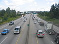
 The "Downtown Connector" (I-75 and I-85) in Atlanta, Georgia, United States of America, during rush hour.
 -
North-South Expressway Simpang Pulai-Gopeng in Malaysia
-


References
- ^ E.L. Yordan, "The 'Freeway' System Expands: Broader Roads With Grade Crossings Eliminated Are Built And Latest Designs Envision Still Greater Speed And Safety", New York Times, 24 February 1935, p. 21.
- ^ Manuel Roig-Franzia, "The Town That Stops Traffic: Travelers Encounter Way Station as Way of Life in Breezewood," Washington Post, 22 November 2001, B1.
- ^ Portions of the Downtown Connector in Atlanta, Georgia has eight lanes in each direction.
- ^ In Mississauga, Ontario, Highway 401 uses collector-express lanes for a total of 18 lanes through its intersection with 403/410 and 427. In San Diego, California, Interstate 5 has a similar system of express and local lanes for a maximum width of 21 lanes on a two-mile segment between Interstate 805 and California State Route 56.
- ^ Anonymous, "Median barriers prove their worth", Public Works 123, no. 3 (March 1992): 72-73.
- ^ Section 1A.13, Paragraph 29, Manual on Uniform Traffic Control Devices, 2003 ed., rev. 1.[1]. See also 23 CFR 750.153(k).
- ^ This part of the word's meaning was codified in 1939 at Section 23.5 of the California Streets and Highways Code.[2] See also People v. Scheinman, 248 Cal. App. 2d 180, 182, 56 Cal. Rptr. 168, 168-169 (1967) (interpreting Section 23.5 to find that a property owner had deeded to the State just the access from the side of his property directly abutting a future freeway but not the access through a connecting road which the state wished to close in order to upgrade an expressway to a freeway).
- ^ Section 1A.13, Paragraph 27, Manual on Uniform Traffic Control Devices, 2003 ed., rev. 1.[3]
- ^ American Association of State Highway Officials, AASHO Highway Definitions (Washington D.C., American Association of State Highway Officials, 1962), 1-3.
- ^ Cal. Sts. & High. Code § 257.
- ^ Miss. Code Ann., § 65-5-3, subds. (b) and (c).
- ^ Mo. Rev. Stat., § 304.010.
- ^ Neb. Rev. Stat., §§ 60-618.01 and 60-621.
- ^ N.D. Cent. Code, § 24-01-01.1 (2006).
- ^ Ohio Rev. Code Ann., § 4511.01, subds. (YY) and (ZZ).
- ^ Wis. Stat., §§ 59.84(1)(b) and 346.57(1)(am).
- ^ Ohio Rev. Code Ann., § 4511.01, subd. (ZZ).
- ^ Hugo Martin, "Sounding Off On Noise: Freeways' Neighbors Struggle To Drown Out Road Racket, Experts Say The Din Creates Mental And Physical Hazards", Los Angeles Times, 20 April 2003, B1.
- ^ Sandy McCreery, "Don't just sit there, enjoy it!" New Statesman, 23 July 2001, 23.
- ^ Martha Smilgis, "Trapped behind the wheel; clever commuters learn to live in the slow lane", Time, 20 July 1987, p. 64-65.
- ^ Gerard Coulombe, "Doing The Turnpike Crawl", New York Times, 6 July 1986, sec. CN, p. 16.
- ^ Jeffrey Spivak, "Today's road opening represents progress, pain", Kansas City Star, 27 July 1999, sec. A, p. 1.
- ^ >Senate Public Works Committee, Noise Pollution and Abatement Act of 1972, S. Rep. No. 1160, 92nd Cong. 2nd session
- ^ [http://www.worldcatlibraries.org/wcpa/top3mset/2930880 C. Michael Hogan and Gary L. Latshaw,The relationship between highway planning and urban noise , :Proceedings of the ASCE, Urban Transportation Division specialty conference, May 21-23, 1973, Chicago, Illinois. by American Society of Civil Engineers. Urban Transportation Division
- ^ TransApex (Brisbane City Council) [4]
- ^ Robert Cervero, "Road expansion, urban growth, and induced travel: a path analysis", Journal of the American Planning Association 69, no. 2 (Spring 2003): 145-164.
- ^ Hugo Martin, "Will More Freeways Bring More Traffic?" Los Angeles Times, 10 April 2002, sec. B, p. 1.
- ^ Drusilla Van Hengel, Joseph DiMento, and Sherry Ryan, Equal Access? Travel Behaviour Change in the Century Freeway Corridor, Los Angeles, Urban Studies 36, no. 1 (March 1999): 547.
- ^ Christy Borth, Mankind on the Move: The Story of Highways (Washington, D.C.: The Automobile Safety Foundation, 1969), 248 and 264.
- ^ Brian D. Taylor, "Public perceptions, fiscal realities, and freeway planning: the California case", Journal of the American Planning Association 61, no. 1 (Winter 1995): 43-59.
- ^ Paul Hofmann, "Taking to the Highway in Italy", New York Times, 26 April 1987, 23.
- ^ Geoffrey Hindley, A History of Roads (London: Peter Davies, 1971), 142.
- ^ Hilaire Belloc, The Highway and Its Vehicles (London: The Studio Limited, 1926), 39.
- ^ Phil Patton, The Open Road: A Celebration of the American Highway (New York: Simon & Schuster, 1986), 77.
- ^ Phil Patton, "A quick way from here to there was also a frolic", Smithsonian 21, no. 7 (October 1990): 96-108.
- ^ Cecilia Rasmussen, "Behind the Wheel: Harrowing Drive on State's Oldest Freeway — Curvy, quirky 110 carries motorists between downtown Los Angeles and Pasadena", Los Angeles Times, 6 November 2001, 2.
- ^ Davison Freeway
- ^ http://www.texasfreeway.com
- ^ Gladwin Hill, "Traffic Chaos Spurs Los Angeles To Plan 'Freeways' On Mass Scale: Coast Metropolis, Lacking Rapid Transit System Such as New York Possesses, Maps $300,000,000 Highway Set-Up", New York Times, 13 January 1947, p. 12.