
Subdivisions of the Polish–Lithuanian Commonwealth: Difference between revisions
rewrite |
|||
| Line 4: | Line 4: | ||
The lands that once belonged to the Commonwealth are now largely distributed among several [[Central European|Central]] and [[Eastern Europe|East Europe]]an countries: Poland, Lithuania, [[Latvia]], [[Ukraine]], [[Belarus]] and [[Russia]], with smaller pieces in [[Estonia]], [[Slovakia]], [[Romania]] and [[Moldova]]. |
The lands that once belonged to the Commonwealth are now largely distributed among several [[Central European|Central]] and [[Eastern Europe|East Europe]]an countries: Poland, Lithuania, [[Latvia]], [[Ukraine]], [[Belarus]] and [[Russia]], with smaller pieces in [[Estonia]], [[Slovakia]], [[Romania]] and [[Moldova]]. |
||
==Terminology== |
|||
While the term "Poland" was also commonly used to denote this whole polity, Poland was in fact only part of a greater whole — the [[Polish-Lithuanian Commonwealth]], which comprised primarily two parts: |
While the term "Poland" was also commonly used to denote this whole polity, Poland was in fact only part of a greater whole — the [[Polish-Lithuanian Commonwealth]], which comprised primarily two parts: |
||
*the [[Crown of the Polish Kingdom]] (Poland proper), colloquially "the Crown"; and |
*the [[Crown of the Polish Kingdom]] (Poland proper), colloquially "the Crown"; and |
||
*the [[Grand Duchy of Lithuania]], colloquially "Lithuania." |
*the [[Grand Duchy of Lithuania]], colloquially "Lithuania." |
||
The Crown in turn comprised two "[[prowincja]]s": [[Greater Poland]] and [[Lesser Poland]]. These and a third province, the Grand Duchy of Lithuania, were the only three regions that were properly termed "provinces." The Commonwealth was further divided into smaller administrative units known as [[voivodeship]]s (''województwa''). Each voivodeship was governed by a [[voivod]] (governor). Voivodeships were further divided into ''[[starostwo|starostwa]]'', each ''starostwo'' <!--Polish language plural/singular - don't correct 'o' to 'a'-->being governed by a ''[[starosta]]''. Cities were governed by [[castellan]]s. There were frequent exceptions to these rules, often involving the ''[[ziemia]]'' subunit of administration: for details on the administrative structure of the Commonwealth, see the article on [[offices in the Polish-Lithuanian Commonwealth]]. |
The Crown in turn comprised two "[[prowincja]]s": [[Greater Poland]] and [[Lesser Poland]]. These and a third province, the Grand Duchy of Lithuania, were the only three regions that were properly termed "provinces." The Commonwealth was further divided into smaller administrative units known as [[voivodeship]]s (''województwa'' - note that some sources use the word [[Palatinate (disambiguation)|palatinate]] instead of [[voivodeship]]). Each voivodeship was governed by a [[voivod]] (governor). Voivodeships were further divided into ''[[starostwo|starostwa]]'', each ''starostwo'' <!--Polish language plural/singular - don't correct 'o' to 'a'-->being governed by a ''[[starosta]]''. Cities were governed by [[castellan]]s. There were frequent exceptions to these rules, often involving the ''[[ziemia]]'' subunit of administration: for details on the administrative structure of the Commonwealth, see the article on [[offices in the Polish-Lithuanian Commonwealth]]. |
||
== Administrative division == |
|||
| ⚫ | |||
By provinces, voivodships and lesser entities. |
|||
| ⚫ | |||
| ⚫ | |||
| ⚫ | |||
| ⚫ | |||
| ⚫ | |||
| ⚫ | |||
| ⚫ | |||
| ⚫ | |||
| ⚫ | |||
| ⚫ | |||
| ⚫ | |||
| ⚫ | |||
| ⚫ | |||
| ⚫ | |||
Commonwealth borders shifted with wars and treaties, sometimes several times in a decade, especially in the eastern and southern regions. |
|||
| ⚫ | |||
| ⚫ | Thought was given at various times to the creation of a [[Duchy of Ruthenia]], particularly during the 1648 [[Cossack]] insurrection against Polish rule in Ukraine. Such a Duchy, as proposed in the [[1658]] [[Treaty of Hadiach]], would have been a full member of the Commonwealth, which would thereupon have become a tripartite [[Polish-Lithuanian-Ruthenian Commonwealth]], but due to szlachta demands, Muscovite invasion, and division among the Cossacks, the plan was never implemented. For similar reasons, plans for a [[Polish-Lithuanian-Muscovite Commonwealth]] also were never realized, although during the [[Polish-Muscovite War (1605-1618)]] the Polish Prince (later, King) [[Władysław IV Waza]] was briefly elected Tsar of Muscovy. |
||
| ⚫ | The Crown had about double the population of Lithuania and five times the income of the latter's treasury. As with other countries, the borders, area and population of the Commonwealth varied over time. After the [[Peace of Jam Zapolski]] ([[1582]]), the Commonwealth had approximately [[1 E8 m²|815,000 km²]] area and a population of 6.5 million. After the [[Truce of Deulino]] ([[1618]]), the Commonwealth had an area of some [[1 E12 m²|1 million km²]] (990,000 km²) and a population of 10–11 million (including some 4 million Poles). |
||
| ⚫ | In the 16th century, the Polish [[bishop]] and [[cartographer]] [[Martin Kromer]] published a [[Latin]] [[Atlas (cartography)|atlas]], entitled [[Polonia sive de situ, populis, moribus, magistratibus et Republica regni Polonici libri duo|''Poland: about Its Location, People, Culture, Offices and the Polish Commonwealth'']], which was regarded as the most comprehensive guide to the country. |
||
| ⚫ | Kromer's works and other contemporary maps, such as those of [[Gerardus Mercator]], show the Commonwealth as mostly [[plain]]s. The Commonwealth's southeastern part, the [[Kresy]], was famous for its [[steppe]]s. The [[Carpathian Mountains]] formed part of the southern border, with the [[Tatra Mountains|Tatra Mountain]] chain the highest, and the [[Baltic Sea]] formed the Commonwealth's northern border. As with most European countries at the time, the Commonwealth had extensive [[forest]] cover, especially in the east. Today, what remains of the [[Białowieża Forest]] constitutes the last largely intact [[primeval forest]] in Europe. |
||
=== Voivodeships of the Commonwealth === |
=== Voivodeships of the Commonwealth === |
||
| Line 119: | Line 96: | ||
* [[Parnawa Voivodeship]] (województwo parnawskie, [[Parnava|Parnawa]]) from [[1598]] to [[1620s]] |
* [[Parnawa Voivodeship]] (województwo parnawskie, [[Parnava|Parnawa]]) from [[1598]] to [[1620s]] |
||
* [[Wenden Voivodeship]] (województwo wendeńskie, [[Cēsis|Wenden]]) from [[1598]] to [[1620s]] |
* [[Wenden Voivodeship]] (województwo wendeńskie, [[Cēsis|Wenden]]) from [[1598]] to [[1620s]] |
||
==== Other ==== |
|||
| ⚫ | |||
| ⚫ | |||
| ⚫ | |||
| ⚫ | |||
| ⚫ | |||
| ⚫ | |||
| ⚫ | |||
| ⚫ | |||
| ⚫ | |||
| ⚫ | |||
| ⚫ | |||
| ⚫ | |||
| ⚫ | |||
| ⚫ | |||
| ⚫ | |||
==Proposed divisions== |
|||
[[Image:Rzeczpospolita_Obojga_Narodow.png|thumb|100px|Coat of Arms for a Polish–<br>Lithuanian–Ruthenian Commonwealth]] |
|||
| ⚫ | Thought was given at various times to the creation of a [[Duchy of Ruthenia]], particularly during the 1648 [[Cossack]] insurrection against Polish rule in Ukraine. Such a Duchy, as proposed in the [[1658]] [[Treaty of Hadiach]], would have been a full member of the Commonwealth, which would thereupon have become a tripartite [[Polish-Lithuanian-Ruthenian Commonwealth]], but due to szlachta demands, Muscovite invasion, and division among the Cossacks, the plan was never implemented. For similar reasons, plans for a [[Polish-Lithuanian-Muscovite Commonwealth]] also were never realized, although during the [[Polish-Muscovite War (1605-1618)]] the Polish Prince (later, King) [[Władysław IV Waza]] was briefly elected Tsar of Muscovy. |
||
==History== |
|||
Commonwealth borders shifted with wars and treaties, sometimes several times in a decade, especially in the eastern and southern regions. Those changes impacted the administrative division, as lands were attached or lost. Sometimes an office would be left for a decades even even if a corresponding province was lost. The Commonwealth controlled the largest territory in the first half of the 17th century, in the second half of the 18th century it had lost significant portions of its territory in the [[partitions of Poland]], finally disappearing from the map of Europe in 1795. |
|||
Please compare: |
|||
<gallery> |
|||
Image:Rzeczpospolita.png|The [[Polish-Lithuanian Commonwealth|Commonwealth]] at its greatest extent - first half of the 17th century |
|||
Image:Rzeczpospolita Rozbiory 1.png|The First Partition (1772) |
|||
Image:Rzeczpospolita Rozbiory 2.png|The Second Partition (1793) |
|||
</gallery> |
|||
==Demographics== |
|||
{{Further|Historical demography of Poland}} |
|||
| ⚫ | The Crown had about double the population of Lithuania and five times the income of the latter's treasury. As with other countries, the borders, area and population of the Commonwealth varied over time. After the [[Peace of Jam Zapolski]] ([[1582]]), the Commonwealth had approximately [[1 E8 m²|815,000 km²]] area and a population of 6.5 million. After the [[Truce of Deulino]] ([[1618]]), the Commonwealth had an area of some [[1 E12 m²|1 million km²]] (990,000 km²) and a population of 10–11 million (including some 4 million Poles). |
||
==Geography== |
|||
| ⚫ | |||
{{Further|Geography of Poland}} |
|||
| ⚫ | In the 16th century, the Polish [[bishop]] and [[cartographer]] [[Martin Kromer]] published a [[Latin]] [[Atlas (cartography)|atlas]], entitled [[Polonia sive de situ, populis, moribus, magistratibus et Republica regni Polonici libri duo|''Poland: about Its Location, People, Culture, Offices and the Polish Commonwealth'']], which was regarded as the most comprehensive guide to the country. |
||
| ⚫ | Kromer's works and other contemporary maps, such as those of [[Gerardus Mercator]], show the Commonwealth as mostly [[plain]]s. The Commonwealth's southeastern part, the [[Kresy]], was famous for its [[steppe]]s. The [[Carpathian Mountains]] formed part of the southern border, with the [[Tatra Mountains|Tatra Mountain]] chain the highest, and the [[Baltic Sea]] formed the Commonwealth's northern border. As with most European countries at the time, the Commonwealth had extensive [[forest]] cover, especially in the east. Today, what remains of the [[Białowieża Forest]] constitutes the last largely intact [[primeval forest]] in Europe. |
||
{{Polish terms for country subdivisions}} |
{{Polish terms for country subdivisions}} |
||
Revision as of 22:22, 5 June 2007

The administrative division of the Polish-Lithuanian Commonwealth was the result of the long and complicated history of the fragmentation of the Polish Kingdom and the union of Poland and Lithuania.
The lands that once belonged to the Commonwealth are now largely distributed among several Central and East European countries: Poland, Lithuania, Latvia, Ukraine, Belarus and Russia, with smaller pieces in Estonia, Slovakia, Romania and Moldova.
Terminology
While the term "Poland" was also commonly used to denote this whole polity, Poland was in fact only part of a greater whole — the Polish-Lithuanian Commonwealth, which comprised primarily two parts:
- the Crown of the Polish Kingdom (Poland proper), colloquially "the Crown"; and
- the Grand Duchy of Lithuania, colloquially "Lithuania."
The Crown in turn comprised two "prowincjas": Greater Poland and Lesser Poland. These and a third province, the Grand Duchy of Lithuania, were the only three regions that were properly termed "provinces." The Commonwealth was further divided into smaller administrative units known as voivodeships (województwa - note that some sources use the word palatinate instead of voivodeship). Each voivodeship was governed by a voivod (governor). Voivodeships were further divided into starostwa, each starostwo being governed by a starosta. Cities were governed by castellans. There were frequent exceptions to these rules, often involving the ziemia subunit of administration: for details on the administrative structure of the Commonwealth, see the article on offices in the Polish-Lithuanian Commonwealth.
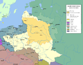
Administrative division
By provinces, voivodships and lesser entities.
Voivodeships of the Commonwealth
Note that some sources use the word palatinate instead of voivodeship.
Greater Poland

- Brześć Kujawski Voivodeship (województwo brzesko-kujawskie, Brześć Kujawski)
- Gniezno Voivodeship (województwo gnieźnieńskie, Gniezno) from 1768
- Inowrocław Voivodeship (województwo inowrocławskie, Inowrocław)
- Kalisz Voivodeship (województwo kaliskie, Kalisz)
- Łęczyca Voivodeship (województwo łęczyckie, Łęczyca)
- Mazovian Voivodeship (województwo mazowieckie, of Mazowsze, Warsaw) consisting of
- County of Ciechanów (ziemia ciechanowska, Ciechanów)
- County of Czersk (ziemia czerska, Czersk)
- County of Liw (ziemia liwska, Liw)
- County of Łomża (ziemia łomżyńska, Łomża)
- County of Nur (ziemia nurska, Nur)
- County of Różan (ziemia różańska, Różan)
- County of Warszawa (ziemia warszawska, Warsaw)
- County of Wisk (ziemia wiska, Wizna)
- Poznań Voivodeship (województwo poznańskie, Poznań)
- Płock Voivodeship (województwo płockie, Płock) consisting of
- County of Płock (ziemia płocka, Płock)
- County of Wyszogród (ziemia wyszogrodzka, Wyszogród)
- County of Zawkrzeń (ziemia zawkrzeńska, Zawkrzeń)
- Podlasie Voivodeship (województwo podlaskie, Drohiczyn) consisting of:
- County of Bielsk (ziemia bielska, Bielsk)
- Country of Drohiczyn (ziemia drohicka, Drohiczyn)
- Country of Mielnik (ziemia mielnicka, Mielnik)
- Rawa Voivodeship (województwo rawskie, Rawa) consisting of
- County of Rawa (ziemia rawska, Rawa)
- County of Gostyń (ziemia gostyńska, Gostyń)
- County of Sochaczew (ziema sochaczewska, Sochaczew)
- Sieradz Voivodeship (województwo sieradzkie, Sieradz)
- County of Dobrzyń (ziemia dobrzyńska, Dobrzyń)
- County of Michałów (ziemia michałkowicka, Michałów)
- County of Wieluń (ziemia wieluńska, Wieluń)
- County of Wschów (ziema wschowska, Wschów)
Lesser Poland
- Bełz Voivodeship (województwo bełzkie, Bełz)
- Bracław Voivodeship (województwo bracławskie, Bracław)
- Czernichów Voivodeship (województwo czernichowskie, Czernichów)
- Kijów Voivodeship (województwo kijowskie, Kijów)
- Kraków Voivodeship (województwo krakowskie, Kraków)
- Lublin Voivodeship (województwo lubelskie, Lublin)
- Podole Voivodeship (województwo podolskie, Kamieniec Podolski)
- Ruś Voivodeship (województwo ruskie, Lwów), divided into
- County of Halicz (ziemia halicka, Halicz)
- County of Lwów (ziemia lwowska, Lwów)
- Country of Przemyśl (ziemia przemyslka, Przemyśl)
- County of Sanock (ziemia sanocka, Sanok)
- Sandomierz Voivodeship (województwo sandomierskie, Sandomierz)
- Wołyń Voivodeship (województwo wołyńskie, Łuck)
- Duchy od Siewierz (księstwo Siewierskie, Siewierz)
- County of Chełm (ziemia chełmska, Chełm)
- Principality of Oświęcim and Zator (Oświęcim, Zator)
Grand Duchy of Lithuania
- Duchy of Samogita (principality of Żmudź, księstwo żmudzkie, Medininkai-Varniai)
- Brześć Litewski Voivodeship (województwo brzesko-litewskie, Brześć Litewski)
- Mścisław Voivodeship (województwo mścisławskie, Mścisław)
- Mińsk Voivodeship (województwo mińskie, Mińsk)
- Nowogródek Voivodeship (województwo nowogrodzkie, Nowogródek)
- Połock Voivodeship (województwo połockie, Połock)
- Smoleńsk Voivodeship (województwo smoleńskie, Smoleńsk)
- Troki Voivodeship (województwo trockie, Troki)
- Wilno Voivodeship (województwo wileńskie, Wilno)
- Witebsk Voivodeship (województwo witebskie, Witebsk)
Royal Prussia
- Duchy of Warmia (Księstwo Warmińskie, episcopal principality of Warmia, Lidzbark Warmiński)
- Chełmno Voivodeship (województwo chełmińskie, Chełmno)
- Malbork Voivodeship (województwo malborskie, Malbork)
- Pomeranian Voivodeship (województwo pomorskie, Gdańsk)
Duchy of Livonia (Inflanty)
- Dorpat Voivodeship (województwo dorpackie, Dorpat) from 1598 to 1620s
- Livonian Voivodeship (województwo inflanckie, Dyneburg) from 1620s
- Parnawa Voivodeship (województwo parnawskie, Parnawa) from 1598 to 1620s
- Wenden Voivodeship (województwo wendeńskie, Wenden) from 1598 to 1620s
Other
Other notable regions of the Commonwealth often referred to, without respect to province or voivodeship divisions, include:
- Lesser Poland (Polish: Małopolska), southern Poland, with its capital at Kraków;
- Greater Poland (Polish: Wielkopolska), west–central Poland, including much of the area drained by the Warta River and its tributaries;
- Masovia (Polish: Mazowsze), central Poland, with its capital at Warsaw;
- Duchy of Livonia (Polish: Inflanty), a joint domain of the Crown and the Grand Duchy of Lithuania. Parts, lost to Sweden in the 1620s and in 1660;
- Courland (Polish: Kurlandia), a northern fief of the Commonwealth. It established a colony in Tobago in 1637 and on St. Andrews Island at the Gambia River in 1651 (see Courland colonization);
- Prussia (Polish: Prusy), parts of which belonged to the Commonwealth:
- Royal Prussia (Polish: Prusy Królewskie), incorporated into the Crown in 1569, at the time of the Commonwealth's formation;
- Duchy of Prussia, a Polish fief until 1660;
- Kresy, the southeastern "Borderlands" of the Crown;
- Ruthenia (Polish: Ruś), the eastern Commonwealth, adjoining Russia;
- Samogitia (Polish: Żmudź), western Lithuania.
- Silesia (Polish: Śląsk) was not part of the Commonwealth, but small parts belonged to various Commonwealth kings; in particular, the Vasa kings were dukes of Opole from 1645 to 1666.
- Pomerania (Polish: Pomorze) is the term for the southern shore of the Baltic Sea, partially outside the Commonwealth and/or in Prussia.
- Galicia (Polish: Galicja) was a term not widely used until the 18th century.
Proposed divisions
Lithuanian–Ruthenian Commonwealth
Thought was given at various times to the creation of a Duchy of Ruthenia, particularly during the 1648 Cossack insurrection against Polish rule in Ukraine. Such a Duchy, as proposed in the 1658 Treaty of Hadiach, would have been a full member of the Commonwealth, which would thereupon have become a tripartite Polish-Lithuanian-Ruthenian Commonwealth, but due to szlachta demands, Muscovite invasion, and division among the Cossacks, the plan was never implemented. For similar reasons, plans for a Polish-Lithuanian-Muscovite Commonwealth also were never realized, although during the Polish-Muscovite War (1605-1618) the Polish Prince (later, King) Władysław IV Waza was briefly elected Tsar of Muscovy.
History
Commonwealth borders shifted with wars and treaties, sometimes several times in a decade, especially in the eastern and southern regions. Those changes impacted the administrative division, as lands were attached or lost. Sometimes an office would be left for a decades even even if a corresponding province was lost. The Commonwealth controlled the largest territory in the first half of the 17th century, in the second half of the 18th century it had lost significant portions of its territory in the partitions of Poland, finally disappearing from the map of Europe in 1795.
Please compare:
-
 The Commonwealth at its greatest extent - first half of the 17th century
 -
 The First Partition (1772)
 -
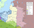 The Second Partition (1793)


Demographics
The Crown had about double the population of Lithuania and five times the income of the latter's treasury. As with other countries, the borders, area and population of the Commonwealth varied over time. After the Peace of Jam Zapolski (1582), the Commonwealth had approximately 815,000 km² area and a population of 6.5 million. After the Truce of Deulino (1618), the Commonwealth had an area of some 1 million km² (990,000 km²) and a population of 10–11 million (including some 4 million Poles).
Geography

In the 16th century, the Polish bishop and cartographer Martin Kromer published a Latin atlas, entitled Poland: about Its Location, People, Culture, Offices and the Polish Commonwealth, which was regarded as the most comprehensive guide to the country.
Kromer's works and other contemporary maps, such as those of Gerardus Mercator, show the Commonwealth as mostly plains. The Commonwealth's southeastern part, the Kresy, was famous for its steppes. The Carpathian Mountains formed part of the southern border, with the Tatra Mountain chain the highest, and the Baltic Sea formed the Commonwealth's northern border. As with most European countries at the time, the Commonwealth had extensive forest cover, especially in the east. Today, what remains of the Białowieża Forest constitutes the last largely intact primeval forest in Europe.