Apricke
|
Apricke
City of Hemer
Coordinates: 51 ° 23 ′ 34 ″ N , 7 ° 48 ′ 40 ″ E
|
||
|---|---|---|
| Residents : | 724 | |
| Postal code : | 58675 | |
| Area code : | 02372 | |
|
Location of Apricke in North Rhine-Westphalia |
||
|
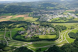
Aerial view of Apricke with Deilinghofen in the background
|
||
Apricke is a district of the North Rhine-Westphalian town of Hemer in the Märkisches Kreis . First mentioned in a document in 1059 , the district belonging to the parish Deilinghofen has 724 inhabitants. The estate of the same name was temporarily owned by the von Werminghausen family .
Apricke is surrounded by the former Apricke training area of the closed Blücher barracks , which, in addition to the military exercises, also served as a local recreation area. A wall surrounding the site has served as protection against noise during military exercises since 1983. Military use took place from 1940 to the beginning of the 21st century. In 2010 the area was acquired by the city of Hemer and the NRW Foundation . The Apricke training area became Apricke - Wilde Weiden on the outskirts of Hemer, where Heck cattle and Dülmen horses graze freely all year round.
Around 1850 the previously independent place was incorporated into the neighboring municipality of Brockhausen .
Apricke can be reached via driveways from the neighboring villages of Riemke and Deilinghofen, which are also part of the municipality of Hemer. The place name is said to be derived from the old Low German words apul - daro - biki, which means apple tree brook.
Personalities
- Lothar Dietrich von Bönninghausen (* 1598, † 1657), General of the Catholic League in the Thirty Years' War
- Beda Vickermann OFM (* 1934, † 2015), Catholic missionary, spent his youth in Apricke
Web links
- Comments on the history of Apricke
- Apricke in the Westphalia Culture Atlas
- Apricke on the Natural Treasures page of South Westphalia
Individual evidence
- ↑ Apricke - Wild pastures on the outskirts of Hemer
- ↑ Stephanie Reekers: The regional development of the districts and communities of Westphalia 1817-1967 . Aschendorff, Münster Westfalen 1977, ISBN 3-402-05875-8 , p. 210 .


