Nieringsen
|
Nieringsen
City of Hemer
Coordinates: 51 ° 21 ′ 5 ″ N , 7 ° 48 ′ 37 ″ E
|
||
|---|---|---|
| Height : | 429 m above sea level NN | |
| Postal code : | 58675 | |
| Area code : | 02372 | |
|
Location of Nieringsen in North Rhine-Westphalia |
||
|
Nieringsen
|
||
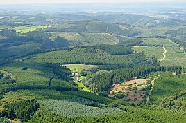
As part of the formerly independent municipality of Deilinghofen, Nieringsen has been part of the town of Hemer in North Rhine-Westphalia since January 1, 1975 . The settlement forms the southernmost part of Deilinghofen and is located in the middle of the Balver Forest .
The village is almost two kilometers south of Langenbruch and Habichtseil and a good kilometer east of Winterhof . The residential buildings are located in the depression between the summit Hochgiebel (482 meters above sea level) and the highest point of the Hemeran urban area (546 meters above sea level) in the east.
The settlement and the name Nieringsen emerged after 1829. Since 1969, some forest areas in the vicinity of Nieringsen have belonged to the Hemer water and municipal utilities, which set up drinking water protection areas there in order to be able to obtain clean water at the drinking water system in Langenbruch .
Individual evidence
- ^ Federal Statistical Office (ed.): Historical municipality directory for the Federal Republic of Germany. Name, border and key number changes in municipalities, counties and administrative districts from May 27, 1970 to December 31, 1982 . W. Kohlhammer, Stuttgart / Mainz 1983, ISBN 3-17-003263-1 , p. 333 .
- ↑ Internet city map : Hemer ( Memento of the original from June 25, 2009 in the Internet Archive ) Info: The archive link was inserted automatically and has not yet been checked. Please check the original and archive link according to the instructions and then remove this notice.
- ^ Karin von Gymnich: From Adjutantenkamp to Zeppelinstrasse. Tell Hemer's street names. 1st edition, Hemer 1986.

