Rathmannsdorf
| coat of arms | Germany map | |
|---|---|---|

|
Coordinates: 50 ° 56 ' N , 14 ° 8' E |
|
| Basic data | ||
| State : | Saxony | |
| County : | Saxon Switzerland-Eastern Ore Mountains | |
| Management Community : | Bad Schandau | |
| Height : | 224 m above sea level NHN | |
| Area : | 4.39 km 2 | |
| Residents: | 912 (Dec. 31, 2019) | |
| Population density : | 208 inhabitants per km 2 | |
| Postal code : | 01814 | |
| Area code : | 035022 | |
| License plate : | PIR, DW, FTL, SEB | |
| Community key : | 14 6 28 320 | |
| LOCODE : | DE RMD | |
| Community structure: | 5 districts | |
| Association administration address: | Dresdner Str. 3 01814 Bad Schandau |
|
| Website : | ||
| Mayor : | Uwe Thiele ( CDU ) | |
| Location of the community Rathmannsdorf in the district of Saxon Switzerland-Eastern Ore Mountains | ||
Rathmannsdorf is a municipality in Saxony near the cities of Hohnstein and Pirna . The municipality is located about two kilometers downstream from Bad Schandau in the natural area of the Elbe Sandstone Mountains on the right bank of the Elbe and borders the Saxon Switzerland National Park . Rathmannsdorf forms together with Bad Schandau and Reinhardtsdorf-Schöna the administrative community Bad Schandau .
geography
The lowest point of the municipality is in the Elbe valley near the Wendischfähre district at an altitude of 120 m above sea level. NN. The highest point is about 245 m above sea level. NHN in the district of Höhe on the flatness above Bad Schandau. The 15 m high barrier-free observation tower , which opened in 2007, is also located here, offering an impressive panoramic view of the rocky landscape of the Elbe Sandstone Mountains . The tower not only has a futuristic architecture, but also an elevator, which enables elderly and disabled people to visit the tower.
Rathmannsdorf consists of the districts Rathmannsdorf and Wendischfähre (incorporated in 1937). The following locations (areas) belong to Rathmannsdorf:
- Höhe: The location Höhe extends on the plateau east of Rathmannsdorf.
- Zauke: The Zauke is located on the slope of the Zaukengrund opposite the S 154 and borders directly on the town of Bad Schandau.
- Plan: The location of Plan is on the Lachsbaches, along the S 163 north of Rathmannsdorf.
- Gluto: The Gluto is located in the Sebnitztal and consists of four residential buildings with the Ochelbaude and the Ochelmühle.
history
Rathmannsdorf was first mentioned in a document in 1445 (Rademsdorff) and was built in the form of a forest hoof village . After its foundation, Rathmannsdorf belonged to the Wildenstein rule , which was owned by the Berken von der Duba family. In 1451, however, the Berken had to cede rule to the Elector of Saxony. In 1467 Rathmannsdorf was bought by the city of Schandau. In 1569 it was returned to the Hohnstein office, but the village came back to Bad Schandau again in 1602. Finally, jurisdiction over Rathmannsdorf went to the Kingdom of Saxony in 1852 and it was administered by the court office in Schandau. From 1875 the village was administered by the Pirna authorities. In 1952 the administration went to the district of Pirna and in 1994 to the district of Saxon Switzerland . In 1937, the previously independent town of Wendischfähre was incorporated.
The place name "Rathmannsdorf" has changed several times in the course of its history and there were different spellings. The following spellings have been handed down from historical sources: 1445: Rademstorff, 1446: Radmenstorff, 1451: Ratmansdorff, Rademastorff, 1547: Ransdorf, 1554: Randorf, 1598: Renßdorf, 1791: Rathmansdorf
Development of the population
- 1547/51: 18 possessed men, 17 residents
- 1764: 17 possessed men, 27 cottagers
- 1834: 341 inhabitants
- 1871: 499 inhabitants
- 1890: 830 inhabitants
- 1910: 1253 inhabitants
- 1925: 1276 inhabitants
- 1939: 1850 inhabitants
- 1946: 2172 inhabitants
- 1950: 2083 inhabitants
- 1964: 1810 inhabitants
- 1990: 1284 inhabitants
- 1999: 1271 inhabitants (808 inhabitants in OT Rathmannsdorf and 363 inhabitants in OT Wendischfähre)
- 2007: 1058 inhabitants
- 2010: 1011 inhabitants
- 2015: 958 inhabitants
politics
Municipal council
Since the municipal council election on May 26, 2019 , the 10 seats of the municipal council have been distributed among the individual groups as follows:
- Rathmannsdorf voters' association (WVR): 4 seats
- Rathmannsdorf citizens' initiative (BI): 6 seats
coat of arms
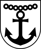
The coat of arms shows an anchor held by seven rings . It goes back to a ferry that crossed the Elbe at the mouth of the Lachsbach . The seven rings symbolize the seven ferry days of the week.
Culture and sights
traffic
Rathmannsdorf is a stop on the Sebnitztalbahn and is served by lines 253 and 260 of the Regionalverkehr Sächsische Schweiz-Osterzgebirge GmbH .
Web links
- Official website of the Rathmannsdorf community
- Rathmannsdorf in the Digital Historical Directory of Saxony
Individual evidence
- ↑ Population of the Free State of Saxony by municipalities on December 31, 2019 ( help on this ).
- ↑ Map services of the Federal Agency for Nature Conservation ( information )
- ↑ barrier-free observation tower on the website of the Rathmannsdorf Guest Association
- ^ Local information community Rathmannsdorf (accessed on March 17, 2018)
- ↑ Digital historical place directory of Saxony .
- ↑ The population of Bad Schandau is falling , Sächsische Zeitung (Pirna edition) from January 26, 2010
- ↑ Results of the 2019 municipal council elections


