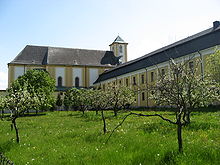
Bílá Voda
| Bílá Voda | ||||
|---|---|---|---|---|
|
||||
| Basic data | ||||
| State : |
|
|||
| Region : | Olomoucký kraj | |||
| District : | Jeseník | |||
| Area : | 1500 ha | |||
| Geographic location : | 50 ° 27 ' N , 16 ° 55' E | |||
| Height: | 305 m nm | |||
| Residents : | 307 (Jan. 1, 2019) | |||
| Postal code : | 790 69 | |||
| License plate : | M. | |||
| traffic | ||||
| Street: | Javorník - Złoty Stok | |||
| structure | ||||
| Status: | local community | |||
| Districts: | 3 | |||
| administration | ||||
| Mayor : | Miroslav Kocián (as of 2018) | |||
| Address: | Kamenička 37 790 69 Bílá Voda |
|||
| Municipality number: | 525227 | |||
| Website : | www.bilavoda.cz | |||
Bílá Voda (German white water ) is a municipality in the Okres Jeseník in the Czech Republic . It is located about nine kilometers northwest of the town of Javorník in the Bílá voda valley directly on the Polish border between the Reichensteiner Mountains ( Rychlebské hory ) and the Patschkauer foreland ( Przedgórze Paczkowskie ) and is the northernmost village of the Javornicko microregion .
history
It is assumed that Weißwasser was probably founded as a resettlement of the village Wyssoka, which is documented between 1267 and 1271 and which later disappeared and to which the cadastral name of Hundorf still reminds us. The first written mention comes from the year 1532. The place name probably refers to the color of the stream that rises there. Since 1848 the settlements of Kamenička ( Kamitz-Uberschar ), Růženec ( Rosary ) and some hermit farms have also belonged to Weißwasser .
Immediately before the First World War there were plans for a cross-border local railway between Jauernig and Reichenstein via Weißwasser, with which a continuous railway connection from Freiwaldau to Kamenz in Silesia would have been realized. The war and its consequences prevented the project. The Reichensteiner railway taught in 1929 instead a bus line between Patschkau and Ladek one.
The market town of Weißwasser had 1104 inhabitants on December 1, 1930, 1024 on May 17, 1939 and 509 on May 22, 1947. According to the Munich Agreement , the place was from October 1938 on German territory and belonged to the Freiwaldau district until 1945 . In order to avoid confusion with other places of the same name, the community used the official name of Weißwasser in Silesia from then on .
The German-speaking residents were expropriated in 1945 and subsequently expelled from the country .
During communist rule, from 1950 onwards, Catholic nuns from all over Czechoslovakia were interned in Bilá Voda , whose monasteries had previously been dissolved and nationalized. At times there were up to 400 women from 16 different orders. The camp existed until the Velvet Revolution in 1989.
In 2012 a small museum was opened that deals with the history of the Bilá Voda nuns internment camp.
Community structure
The municipality of Bílá Voda consists of the districts Kamenička ( Kamitz-Uberbar ), Městys Bílá Voda ( white water market ) and Ves Bílá Voda ( white water village ). Bílá Voda also includes the abandoned settlements Karlov ( Karlshof ), U šišky even Jedlová šiška or Jedlovec ( pine cones ), Na Vyhlídce ( watch ) and Růženec ( Rosary ). Basic settlement units are Bílá Voda, Kamenička and Kamenička-u Bílé Vody.
The municipality is divided into the cadastral districts of Bílá Voda u Javorníka and Kamenička u Bílé Vody.
Attractions
- Bílá Voda Castle
- The parish church of the Visitation of the Virgin Mary was built according to plans by the Silesian architect Felix Anton Hammerschmidt and inaugurated in 1777 by the Breslau bishop Philipp Gotthard von Schaffgotsch .
- The Piarist College was founded by the Olomouc bishop Jakob Ernst von Liechtenstein-Kastelkorn .
- Muzeum izolace, internace a integrace
Sons and daughters of the church
- Axel Alexander (born May 15, 1926 in Weißwasser in Silesia; † June 17, 2016 in Mühldorf am Inn ), composer, arranger and Hammond organ player
Web links
Individual evidence
- ↑ http://www.uir.cz/obec/525227/Bila-Voda
- ↑ Český statistický úřad - The population of the Czech municipalities as of January 1, 2019 (PDF; 7.4 MiB)
- ↑ http://www.dradio.de/dlf/sendung/tagfuertag/1921831/
- ↑ http://www.uir.cz/casti-obce-obec/525227/Obec-Bila-Voda
- ↑ http://www.uir.cz/zsj-obec/525227/Obec-Bila-Voda
- ↑ http://www.uir.cz/katastralni-uzemi-obec/525227/Obec-Bila-Voda
- ↑ Obituary (accessed July 10, 2017)
- ↑ Not clearly. This Weißwasser / Bílá Voda belonged to Czechoslovakia in 1926.


