
Barda (Perm)
| Village
Barda
Барда
|
||||||||||||||||||||||||||||||
|
||||||||||||||||||||||||||||||
|
||||||||||||||||||||||||||||||
.png)
.svg)

Barda ( Russian Барда́ ) is a village (selo) in the Perm region in Russia with 8,826 inhabitants (as of October 14, 2010).
geography
The place is about 125 km as the crow flies south-southwest of the Perm regional administrative center in the western foothills of the Urals , below the confluence of the left, eponymous tributary Barda in the left Kama tributary Tulwa . The also left Tulwa tributary Kasmak (also Kasmakty ) flows through the place .
Barda is the administrative center of Bardymsky Rajons and the seat of the rural community Bardymskoje selskoje posselenije, which also includes the villages of Mostovaya (4 km northwest), Stary Chad (10 km west) and Chalkovo (7 km north). Almost two thirds of the population are ( Tatar-speaking ) Bashkirs , almost one third are Tatars , and only about 5% are ethnic Russians .
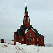
Main mosque
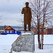
Lenin monument

Culture, leisure and sports palace

shopping mall

Entrance


.jpg)
.jpg)
history
The place was first mentioned around 1630, later in the middle of the 18th century in connection with the construction of a mosque and a madrasa for the predominantly Bashkir Muslim population who lived there . From 1781 Barda belonged to the Ujesd Ossa of the governorship of Perm, from 1796 of the Perm governorate . Alternatively, it was also referred to as Kasmak (ty) after the river , to distinguish it from the village of Nizhnyaya Barda ("Lower Barda") located in the same Ujesd a good 30 km to the west.
On November 4, 1926, Barda became the seat of a Rajons named after him. From February 1962 to January 12, 1965 the Rajon was temporarily dissolved.
Population development
| year | Residents |
|---|---|
| 1897 | 2099 |
| 1926 | 2447 |
| 1939 | 3305 |
| 1959 | 3881 |
| 1970 | 4977 |
| 1979 | 5803 |
| 1989 | 7667 |
| 2002 | 8490 |
| 2010 | 8826 |
Note: census data
traffic
The Perm - Ufa regional road runs north-east of Barda and was previously designated as the R315. The section Ossa - Tschernuschka via Barda bears the number 57K-0006 today. To the south, the 57K-0017 branches off as a shorter alternative route to the neighboring district center of Kujeda , where it again joins the former R315. There is also the nearest railway station at km 1271 on the Moscow - Kazan - Yekaterinburg railway line a good 50 km away .
Web links
Individual evidence
- ↑ a b Itogi Vserossijskoj perepisi naselenija 2010 goda. Tom 1. Čislennostʹ i razmeščenie naselenija (Results of the All-Russian Census 2010. Volume 1. Number and distribution of the population). Tables 5 , pp. 12-209; 11 , pp. 312–979 (download from the website of the Federal Service for State Statistics of the Russian Federation)
| Cities |
Alexandrovsk R | Berezniki S | Dobryanka R | Gornozavodsk R | Gremjachinsk R | Gubacha R | Kisel R | Krasnokamsk R | Krasnovishersk R | Kudymkar S / R * | Kungur S / R | Lyswa R | Nytwa R | Ochansk R | Ossa R | Otschor R | Perm S / R | Solikamsk S / R | Tchaikovsky R | Cherdyn R | Chernushka R | Chormos | Chusovoy R | Ussolye R | Vereshchagino R |
|
| Urban-type settlements |
Bitter | Jaiwa | Kalino | Kussje-Alexandrowski | Ljamino | Medvedka | Novoiljinsky | Novowilwensky | Nyrob | Oktjabrski R | Owerjata | Pashia | Pavlovsky | Polasna | Promysla | Sarany | Sars | Shirokovsky | Skalny | Stary Bisser | Suksun R | Svyosdny S / G | Tjoplaja Gora | Ugleuralski | Uralsky | Etc. | Vsevolodo-Wilwa |
|
| Other Rajon centers |
Barda | Beryosovka | Bolshaya Sosnova | Gainy * | Ilyinsky | Jelowo | Jurla * | Yuswa * | Karagai | Kossa * | Kochovo * | Kujeda | Orda | Siwa | Chastye | Uinskoye | Ust-Kischert |