San Juan de Tarucani district
| San Juan de Tarucani district | |
|---|---|
 The district of San Juan de Tarucani is located in the far east of the province of Arequipa (marked in red) |
|
| Basic data | |
| Country | Peru |
| region | Arequipa |
| province | Arequipa |
| Seat | San Juan de Tarucani |
| surface | 2,264.6 km² |
| Residents | 1377 (2017) |
| density | 0.6 inhabitants per km² |
| founding | June 15, 1962 |
| ISO 3166-2 | PE-ARE |
| politics | |
| Alcalde District | Orlink Choque Velázquez (2019-2022) |
| Political party | Arequipa Transformación |
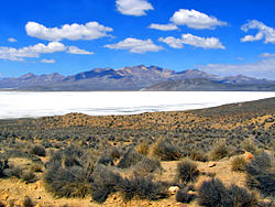
| Laguna Salinas | |
Coordinates: 16 ° 11 ′ S , 71 ° 4 ′ W
The San Juan de Tarucani district is located in the Arequipa Province of Arequipa region in southwestern Peru . The district was founded on January 2, 1857. It has an area of 2264.59 km². At the 2017 census, there were 1,377 residents in the district. In 1993 the population was 2110, in 2007 2129. The district administration is located in the 4210 m high village of San Juan de Tarucani . San Juan de Tarucani is located 55 km east-northeast of the provincial and regional capital Arequipa .
Geographical location
The district of San Juan de Tarucani is located in the far east of the province of Arequipa. It is located in the mountains of the Peruvian Western Cordillera . The upper reaches of the Río Chili runs along the northern western border of the district. The Aguada Blanca dam is located on the western edge of the district. The Misti and Picchu Picchu volcanoes rise to the west and south-west of the district. The Laguna Salinas salt lake is located in the south of the district . In the north of the district is the El Frayle dam on the Río Blanco , a tributary of the Río Chili. Most of the district lies within the Reserva nacional de Salinas y Aguada Blanca .
The district of San Juan de Tarucani borders in the west on the districts Pocsi , Characato , Chiguata , Cayma and Yura , in the north on the district San Antonio de Chuca ( province Caylloma ), in the extreme northeast on the district Cabanillas ( province San Román , region Puno) ), to the east to the districts of Ubinas and Matalaque (both in the province of General Sánchez Cerro , Moquegua region ) and to the south to the districts of Coalaque and Puquina (also in the province of General Sánchez Cerro).
Locations in the district
- Cancosani
- Carmen de Chaclaya
- Condorí
- Huayllacucho
- La Yunta
- Pati
- Pucasaya
- Salinas Huito
- San Juan de Tarucani
Individual evidence
- ↑ a b Peru: Arequipa - Provinces & Districts . www.citypopulation.de. Retrieved March 2, 2020.

