
Durance (Lot-et-Garonne)
|
Durance Durança |
||
|---|---|---|
|
||
| region | Nouvelle-Aquitaine | |
| Department | Lot-et-Garonne | |
| Arrondissement | Nérac | |
| Canton | Les Forêts de Gascogne | |
| Community association | Coteaux et Landes de Gascogne | |
| Coordinates | 44 ° 10 ′ N , 0 ° 10 ′ E | |
| height | 111-166 m | |
| surface | 38.6 km 2 | |
| Residents | 293 (January 1, 2017) | |
| Population density | 8 inhabitants / km 2 | |
| Post Code | 47420 | |
| INSEE code | 47085 | |

Durance ( Occitan : Durança ) is a municipality with 293 inhabitants (as of January 1 2017) in France in the department of Lot-et-Garonne in the region Nouvelle-Aquitaine . The municipality belongs to the Arrondissement Nérac and the canton Les Forêts de Gascogne (until 2015: Canton Houeillès ). The inhabitants are called Durançais .
geography
Durance is about 37 kilometers west-southwest of Agen . Durance is surrounded by the neighboring communities of Fargues-sur-Ourbise in the north, Pompiey in the northeast, Barbaste in the east, Réaup-Lisse in the south and southeast and Boussès in the west.
history
Durance was founded as a bastide around 1320.
Population development
| year | 1962 | 1968 | 1975 | 1982 | 1990 | 1999 | 2006 | 2013 |
| Residents | 412 | 364 | 334 | 283 | 286 | 269 | 266 | 281 |
| Source: Cassini and INSEE | ||||||||
Attractions
- Saint-Etienne church from the 15th century
- old priory Saint-Etienne-de-la-Grange from the 13th century
- lock
- Remains of the fortifications

Saint-Etienne church
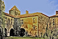
lock

Remains of the fortifications and gate

Priory with chapel


Web links
Commons : Durance - collection of images, videos and audio files