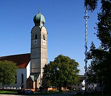
Unterreit
| coat of arms | Germany map | |
|---|---|---|

|
Coordinates: 48 ° 7 ' N , 12 ° 20' E |
|
| Basic data | ||
| State : | Bavaria | |
| Administrative region : | Upper Bavaria | |
| County : | Mühldorf am Inn | |
| Management Community : | Gars on the Inn | |
| Height : | 530 m above sea level NHN | |
| Area : | 32.19 km 2 | |
| Residents: | 1725 (Dec. 31, 2019) | |
| Population density : | 54 inhabitants per km 2 | |
| Postal code : | 83567 | |
| Area code : | 08073 | |
| License plate : | MÜ, VIB , WS | |
| Community key : | 09 1 83 147 | |
| Community structure: | 75 districts | |
| Association administration address: | Hauptstrasse 3 83536 Gars am Inn |
|
| Website : | ||
| Mayor : | Christian Seidl ( FWG Wang ) | |
| Location of the community of Unterreit in the Mühldorf am Inn district | ||
Unterreit is a municipality in the Upper Bavarian district of Mühldorf am Inn and a member of the administrative community of Gars am Inn .
geography
The municipality is located in the planning region of southeast Upper Bavaria , about 55 km east of Munich .
Community structure
The community of Unterreit has 75 districts:
There are the districts Elsbeth, Grünthal, Wald and Wang.
history
Administrative history
Unterreit was part of the Burghausen Rent Office and the Kling District Court of the Electorate of Bavaria . Parts of today's municipality (Elsbeth) were located in the closed Hofmark Mittergars of the Archbishopric of Salzburg until it was abolished in 1803 . In the course of the administrative reforms in Bavaria , today's municipality was created with the municipal edict of 1818 .
Incorporations
On April 1, 1971, the previously independent communities of Elsbeth, Grünthal and Wang (with the community of Wald, which was added on November 22, 1876) were combined to form the community of Unterreit (name of a district of Elsbeth).
Population development
Between 1988 and 2018 the municipality grew from 1,402 to 1,692 by 290 inhabitants or by 20.7%.
- 1961: 1389 inhabitants
- 1970: 1385 inhabitants
- 1987: 1354 inhabitants
- 1991: 1453 inhabitants
- 1995: 1539 inhabitants
- 2000: 1623 inhabitants
- 2005: 1668 inhabitants
- 2010: 1705 inhabitants
- 2015: 1715 inhabitants
politics
Mayor is Christian Seidl (FWG).
Culture and sights
- Parish church of St. Andreas in Grünthal
- Wildlife park Oberreith with forest ropes course and 35 m high observation tower with zip line Flying Fox
Economy and Infrastructure
Economy including agriculture and forestry
The municipal tax revenue amounted to the equivalent of 593 T € in 1999, of which 137 T € (net) was trade tax income.
In 1998 there were nine employees in agriculture and forestry, 182 in manufacturing and 25 in trade and transport at the place of work. In other economic sectors 40 people were employed at the place of work subject to social security contributions. There were 493 employees at the place of residence subject to social security contributions. There was one in the manufacturing sector and seven in the construction sector. In addition, in 1999 there were 109 farms with an agriculturally used area of 2054 ha. Of this, 1124 ha were arable land and 928 ha were permanent green space.
education
In 1999 the following institutions existed:
- Kindergartens: 50 kindergarten places with 54 children
Individual evidence
- ↑ "Data 2" sheet, Statistical Report A1200C 202041 Population of the municipalities, districts and administrative districts 1st quarter 2020 (population based on the 2011 census) ( help ).
- ↑ http://www.bayerische-landesbibliothek-online.de/orte/ortssuche_action.html ? Anzeige=voll&modus=automat&tempus=+20120105/184504&attr=OBJ&val= 421
- ^ Wilhelm Volkert (ed.): Handbook of Bavarian offices, communities and courts 1799–1980 . CH Beck, Munich 1983, ISBN 3-406-09669-7 , p. 589 .
- ↑ Wildfreizeitpark Oberreith on the website of Wildpark Oberreith GmbH & Co. KG
- ↑ Flying Fox and observation tower Wildpark Oberreith on muehldorfer-netz.de
Web links
- Entry on the coat of arms of Unterreit in the database of the House of Bavarian History


