
Gisselberg
|
Gisselberg
City of Marburg
Coordinates: 50 ° 46 ′ 21 ″ N , 8 ° 45 ′ 0 ″ E
|
|
|---|---|
| Height : | 176 (176–290) m above sea level NHN |
| Area : | 1.77 km² |
| Residents : | 910 (December 31, 2016) |
| Population density : | 514 inhabitants / km² |
| Incorporation : | July 1, 1974 |
| Postal code : | 35043 |
| Area code : | 06421 |
 Location of Gisselberg in Marburg
|
|
Gisselberg is a district of Marburg an der Lahn in the district of Marburg-Biedenkopf in Central Hesse .
geography
Gisselberg is located on the Lahn on the Marburg Ridge, southwest of Marburg. The federal highway 255 runs through the town, the federal highway 3 on the eastern edge of the town.
history
The village was first mentioned around 1300 with the place name Goselberg . Between 1973 and 1975 a cemetery chapel was built as a church.
On July 1, 1974, the previously independent municipality was incorporated into the city of Marburg by state law as part of the regional reform in Hesse .
Territorial history and administration
The following list gives an overview of the territories in which Gisselberg was located and the administrative units to which it was subordinate:
- before 1567: Holy Roman Empire , Landgraviate of Hesse , Oberweimar court also called Reitzberg (Oberweimar court consisted of the places Oberweimar, Niederwalgern, Kehna, Altna, Weiershausen, Hermershausen, Ciriaxweimar, Gisselberg, Ronhauſen and Wolfshausen, as well as half of Dilschhausen and Elnhausen)
- from 1567: Holy Roman Empire, Landgraviate Hessen-Marburg , Marburg Office, Oberweimar Court
- 1604–1648: Holy Roman Empire, disputed between Landgraviate Hessen-Darmstadt and Landgraviate Hessen-Kassel ( Hessian War ), Marburg Office, Oberweimar court
- from 1648: Holy Roman Empire, Landgraviate Hessen-Kassel, Marburg Office, Oberweimar Court
- from 1803: Holy Roman Empire, Electorate of Hesse , Office of Kaldern and Reitzberg
- from 1806: Electorate of Hesse, Amt Kaldern and Reitzberg
- 1807–1813: Kingdom of Westphalia , department of Werra , district of Marburg , canton of Marburg
- from 1815: German Confederation , Electorate of Hesse, Office of Kaldern and Reitzberg
- from 1821: German Confederation, Electorate of Hesse, Province of Upper Hesse , District of Marburg (separation of justice ( district court Marburg ) and administration)
- from 1848: German Confederation, Electorate of Hesse, Marburg district
- from 1851: German Confederation, Electorate of Hesse, Province of Upper Hesse, District of Marburg
- from 1866: North German Confederation , Kingdom of Prussia , Province of Hesse-Nassau , District of Kassel , District of Marburg
- from 1871: German Empire , Kingdom of Prussia, Province of Hessen-Nassau, District of Kassel, District of Marburg
- from 1918: German Empire, Free State of Prussia , Province of Hessen-Nassau, Administrative Region of Kassel, District of Marburg
- from 1944: German Empire, Free State of Prussia, Province of Kurhessen , District of Marburg
- from 1945: American zone of occupation , Greater Hesse , Kassel district, Marburg district
- from 1949: Federal Republic of Germany , State of Hesse , Kassel district, Marburg district
- on December 31, 1971 Bortshausen was incorporated into the municipality of Cappel .
- 1974: Federal Republic of Germany, Land Hessen, Kassel , Marburg-Biedenkopf
- on July 1, 1974, the districts of Cappel were incorporated as districts of Marburg.
- from 1981: Federal Republic of Germany, State of Hesse, Gießen district, Marburg-Biedenkopf district
Courts since 1821
With an edict of June 29, 1821, administration and justice were separated in Kurhessen. Now judicial offices were responsible for the first instance jurisdiction, the administration was taken over by the districts. In Marburg, the district of Marburg was set up for administration and the Marburg district court was the first-instance court responsible for Gisselberg. In 1850 the regional court was renamed the Marburg Justice Office. The Supreme Court was the Higher Appeal Court in Kassel . The higher court of Marburg was subordinate to the province of Upper Hesse. It was the second instance for the judicial offices.
After the annexation of Kurhessen by Prussia, the Marburg district court became the royal Prussian district court of Marburg in 1867 . In June 1867, a royal ordinance was issued that reorganized the court system in the areas that belonged to the former Electorate of Hesse. The previous judicial authorities were to be repealed and replaced by local courts in the first, district courts in the second and an appeal court in the third instance. In the course of this, on September 1, 1867, the previous judicial office was renamed the Marburg District Court. The courts of the higher authorities were the Marburg District Court and the Kassel Court of Appeal .
Even with the entry into force of the Courts Constitution Act of 1879, the district court remained under his name. In the Federal Republic of Germany, the superordinate instances are the Marburg Regional Court , the Frankfurt am Main Higher Regional Court and the Federal Court of Justice as the last instance.
population
Population development
Source: Historical local dictionary
| • 1577: | 8 home- seated teams |
| • 1630: | 7 house seats (3 three-horse, 2 two-horse, 2 single-horse farm workers) |
| • 1681: | 5 home-seated teams |
| • 1838: | 124 inhabitants (7 local residents who are entitled to use, 12 residents who are not entitled to use, 6 residents ). |
| Gisselberg: Population from 1746 to 2015 | ||||
|---|---|---|---|---|
| year | Residents | |||
| 1746 | 59 | |||
| 1834 | 122 | |||
| 1840 | 129 | |||
| 1846 | 142 | |||
| 1852 | 149 | |||
| 1858 | 157 | |||
| 1864 | 123 | |||
| 1871 | 117 | |||
| 1875 | 129 | |||
| 1885 | 139 | |||
| 1895 | 137 | |||
| 1905 | 128 | |||
| 1910 | 135 | |||
| 1925 | 162 | |||
| 1939 | 196 | |||
| 1946 | 302 | |||
| 1950 | 336 | |||
| 1956 | 359 | |||
| 1961 | 374 | |||
| 1967 | 474 | |||
| 1987 | 681 | |||
| 1991 | 635 | |||
| 1995 | 656 | |||
| 2000 | 717 | |||
| 2003 | 849 | |||
| 2005 | 906 | |||
| 2007 | 925 | |||
| 2010 | 914 | |||
| 2011 | 813 | |||
| 2015 | 866 | |||
| Data source: Historical municipality register for Hesse: The population of the municipalities from 1834 to 1967. Wiesbaden: Hessisches Statistisches Landesamt, 1968. Further sources:; 1987-1998, 1999-2003; 2005-2010; 2011 census : 2011–2015 | ||||
Religious affiliation
Source: Historical local dictionary
| • 1861: | 284 Evangelical Lutheran and 2 Roman Catholic residents |
| • 1885: | 138 Protestant (= 100.00%) residents |
| • 1961: | 324 Protestant (= 86.63%), 47 Catholic (= 12.57%) residents |
| • 1987: | 394 Protestant (= 67.8%), 87 Catholic (= 15.0%) residents |
Gainful employment
Source: Historical local dictionary
| • 1746: | Labor force: 1 blacksmith, 1 white binder, 2 landlords, 1 minstrel, 1 day laborer. |
| • 1838: | Families: 8 agriculture, 8 trades, 9 day laborers. |
| • 1961: | Labor force: 33 agriculture and forestry, 80 manufacturing, 41 trade and transport, 24 services and other. |
Buildings
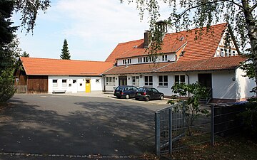
Community center
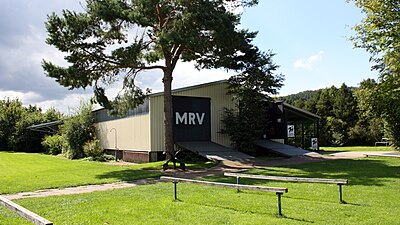
Boathouse
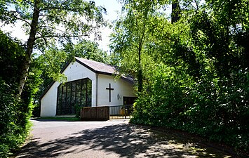
church


.jpg)
Infrastructure
There is a church kindergarten, a village community center and a football field in the village . The boathouse of the Marburg rowing club is on the Lahn .
literature
- Walter Bernsdorff: Gisselberg: the village of five courtyards (series: Marburger Stadtschriften zur Geschichte und Kultur, Volume 64), Marburg 1998, ISBN 3-923820-64-X .
- Search for Gisselberg in the archive portal-D of the German Digital Library
Web links
- Gisselberg district. In: Internet presence. City of Marburg
- Gisselberg, Marburg-Biedenkopf district. Historical local dictionary for Hessen. In: Landesgeschichtliches Informationssystem Hessen (LAGIS).
Individual evidence
- ↑ Marburg figures from 2009-2010 on the website of the city of Marburg (pdf; p. 4)
- ↑ a b Population figures from 2011 to 2016. (PDF; 46 kB) In: Website. City of Marburg, p. 4 ff , accessed in January 2019 .
- ↑ a b c d e f Gisselberg, Marburg-Biedenkopf district. Historical local dictionary for Hessen. (As of May 23, 2018). In: Landesgeschichtliches Informationssystem Hessen (LAGIS).
- ↑ Law on the reorganization of the Biedenkopf and Marburg districts and the city of Marburg (Lahn) (GVBl. II 330-27) of March 12, 1974 . In: The Hessian Minister of the Interior (ed.): Law and Ordinance Gazette for the State of Hesse . 1974 No. 9 , p. 154 , § 1 ( online at the information system of the Hessian state parliament [PDF; 3.0 MB ]).
- ^ Federal Statistical Office (ed.): Historical municipality directory for the Federal Republic of Germany. Name, border and key number changes in municipalities, counties and administrative districts from May 27, 1970 to December 31, 1982 . W. Kohlhammer GmbH, Stuttgart / Mainz 1983, ISBN 3-17-003263-1 , p. 387 .
- ^ Michael Rademacher: German administrative history from the unification of the empire in 1871 to the reunification in 1990. State of Hesse. (Online material for the dissertation, Osnabrück 2006).
- ^ Georg Landau: Description of the Electorate of Hesse . T. Fischer, Kassel 1842, p. 370 ( online at HathiTrust's digital library ).
- ^ The affiliation of the Marburg office based on maps from the Historical Atlas of Hessen : Hessen-Marburg 1567–1604 . , Hessen-Kassel and Hessen-Darmstadt 1604–1638 . and Hessen-Darmstadt 1567–1866 .
- ^ Kur-Hessischer Staats- und Adress-Kalender: 1818 . Publishing house d. Orphanage, Kassel 1818, p. 107 ( online at Google Books ).
- ↑ Ordinance of August 30th, 1821, concerning the new division of the area , Annex: Overview of the new division of the Electorate of Hesse according to provinces, districts and judicial districts. Collection of laws etc. for the Electoral Hesse states. Year 1821 - No. XV. - August., ( Kurhess GS 1821) pp. 223–224 .
- ↑ Latest news from Meklenburg / Kur-Hessen, Hessen-Darmstadt and the free cities, edited from the best sources. in the publishing house of the GHG privil. Landes-Industrie-Comptouts., Weimar 1823, p. 158 ff . ( online at HathiTrust's digital library ).
- ↑ Ordinance on the constitution of the courts in the former Electorate of Hesse and the formerly Royal Bavarian territories with the exclusion of the enclave Kaulsdorf from June 19, 1867. ( PrGS 1867, pp. 1085-1094 )
- ↑ Order of August 7, 1867, regarding the establishment of the according to the Most High Ordinance of June 19 of this year. J. in the former Electorate of Hesse and the formerly Royal Bavarian territorial parts with the exclusion of the enclave Kaulsdorf, courts to be formed ( Pr. JMBl. Pp. 221–224 )
- ↑ a b Population figures from 1995 to 1998. (PDF; 3.7 MB) In: Website. City of Marburg, p. 9 ff , accessed in January 2019 .
- ↑ Population figures from 1999 to 2003 (PDF; 7.75 MB) In: Website. City of Marburg, p. 8 ff , accessed in January 2019 .
- ↑ Population figures from 2005 to 2010. (PDF; 1.13 MB) In: Website. City of Marburg, p. 10 ff , accessed in January 2019 .

Bauerbach | Bortshausen | Cappel | Cyriaxweimar | Dagobertshausen | Dilschhausen | Elnhausen | Ginseldorf | Gisselberg | Haddamshausen | Hermershausen | Marbach | Michelbach | Moischt | Ockershausen | Richtsberg | Ronhausen | Schröck | Wehrda | Wehrshausen