Gateway Arch National Park
| Gateway Arch National Park | ||
|---|---|---|
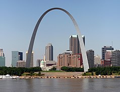
| Gateway Arch, 2007 | ||
|
|
||
| Location: | Missouri , United States | |
| Surface: | 0.78 km² | |
| Founding: | February 22, 2018 | |
| Visitors: | 2,016,180 (2018) | |
The Gateway Arch National Park (formerly Jefferson National Expansion Memorial ; German : "Memorial to national expansion by Jefferson") is a national park in St. Louis in the US state of Missouri . Its current location indicates the starting point of the Lewis and Clark expedition . The memorial also commemorates other historical events such as the Louisiana Purchase and the subsequent settlement of the West, the first civil government west of the Mississippi and the Dred Scott v. Sandford .
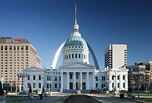
Central structure of the memorial site is accessible to the public 192 meters high Gateway Arch ( German : "arch"). The ensemble of the memorial includes the arch, the old courthouse and the Museum of Westward Expansion , which, together with the visitor center , is located underground and below the Gateway Arch. The memorial is one of the National Memorials in the United States and is administered by the National Park Service ; In 2005 it recorded a total of 2,944,976 visitors. The park area of the memorial has been declared a Category V protected area by the International Union for Conservation of Nature and Natural Resources .
location
The buildings belonging to the Gateway Arch National Park are located on several 78 hectares of land in the eastern part of downtown St. Louis ( Downtown East ). The Gateway Arch as the architectural dominant feature stands in a roughly 36.8 hectare, rectangular park area that is partially planted with trees. In addition to the Gateway Arch, the park also houses the associated visitor center and the Museum of Westward Expansion . Two artificial lakes ( North Pond and South Pond ) with amorphous shorelines are located on both sides of these facilities . The property is framed to the west by Interstate 70 - at the level of the memorial the street is called Memorial Drive - and to the east by Leonor Kretzer Sullivan Boulevard, a street on the Mississippi River . There are several landing stages on the bank at the Expansion Memorial . The Gateway Arch can be reached from the embankment via a flight of stairs . North of the park is Arch-Laclede's Landing station on the MetroLink tram .
From the east bank of the Mississippi, the great arch dominates the view of downtown St. Louis. In the western extension of the vertical axis of symmetry of the Gateway Arch is the old courthouse . The St. Louis Basilica , the former cathedral of St. Louis, is located on the eastern edge of the park area ; however, the church is not part of the memorial. On the east side of the Mississippi River, which belongs to the city of East St. Louis , Illinois , is just east of the arch of the Gateway Geyser in Malcolm W. Martin Memorial Park. The approximately 192 meter high fountain is the third highest in the world after the King Fahd's Fountain and just as high as the Gateway Arch.
history
Background and beginnings of the memorial
The Jefferson National Expansion Memorial is named in honor of the third US President, Thomas Jefferson , who bought the 2.1 million square kilometer former colony of Louisiana from France for $ 15 million in 1803 . The solemn surrender of the territory to the United States took place on March 10, 1804 in St. Louis. This largest real estate deal in history doubled the size of the USA at the time and created the basis for the Lewis and Clark expedition from May 14, 1804 to September 23, 1806, which ultimately led to the expansion of the USA to the Pacific coast. The expedition beginning in St. Louis encouraged both private and government expeditions to make the area accessible to the west. The Gateway Arch National Park is seen as emblematic of the visionary foresight of Jefferson, which awakened the pioneering spirit and laid the foundation of the modern USA as it spread to the west.
Ideas for a memorial to these historical events had existed since the end of the 19th century. They usually went hand in hand with various proposals for the urban redesign of the St. Louis riverside area. The city planner and architect Harland Bartholomew worked out detailed plans for the development of the eastern inner city in 1928. However, none of these projects could win the necessary majority in public. The present memorial is the result of efforts by attorney Luther Ely Smith , who first voiced the idea in 1933. He convinced the then US President Franklin D. Roosevelt to build a memorial for the Louisiana Purchase in St. Louis. Roosevelt is said to have been enthusiastic about the idea from the start. In April 1934, the committee received state approval and the Jefferson National Expansion Memorial Association was declared a nonprofit .
On February 1, 1935, an expert committee met, consisting of members of the memorial committee and President Roosevelt. Questions about the further development were discussed, the architectural competition to be arranged, the scheduled project duration and the financing of the project, the total cost of which was estimated at 30 million US dollars. In addition to the costs for the structures and land, the costs for the development of new building land had to be taken into account. Roosevelt doubted that he could afford these federal funds. On April 13th, the commission approved the plans. Smith and Mayor Bernard F. Dickmann reached out to then Home Secretary Harold L. Ickes to see what more funds they could get. In order to cover the costs, a bond worth $ 7.5 million was issued on July 1st by municipal decree . Ickes secured loans and grants from the federal government and other public institutions. A property matching the memorial was purchased on September 10, 1935 for $ 7.5 million. The site was officially established on December 21, 1935 by Executive Order No. 7253 of President Roosevelt. At the height of the Great Depression in 1935, he declared that the construction of the memorial both have symbolic value and would work to counter unemployment.
On October 14, 1936, President Roosevelt inaugurated the Soldiers Memorial in St. Louis and also surveyed the property on the Mississippi that was intended for the new Jefferson National Expansion Memorial . In June 1937, the purchase of further suitable properties began. Most were acquired within the next two years. On October 10, 1939, work began on the waterfront. Between 1939 and 1942, 40 blocks were demolished to make way for the memorial. Only the old courthouse and the old cathedral remained. In May 1940, Roosevelt signed a document declaring the old courthouse to be part of the memorial. With this first structure, the memorial officially opened on December 1, 1941. The Museum of National Expansion temporarily opened on October 20, 1942 pending the completion of the memorial in the courthouse premises.
Planning the Gateway Arch
On October 22, 1946, a nationwide architecture competition reserved exclusively for US citizens with prize money of 50,000 US dollars was called for the design of the central part of the memorial. 172 architects participated, including important names such as Walter Gropius , Charles Eames , the Skidmore office , Owings and Merrill , Louis I. Kahn , Eugene Mackey , Edward Stone and Kazumi Adachi . Other participants were the established Finnish-American architect Eliel Saarinen and his 38-year-old son Eero , who was at the beginning of his career and who, in cooperation with the landscape architect Dan Kiley, submitted a project that was independent of his father.
Eliel Saarinen finally received an only to “E. Saarinen ” to be one of the five finalists. This soon turned out to be a mistake, as in reality his son Eero was meant, who ultimately emerged victorious from the competition. This success was Eero Saarinen's breakthrough as an internationally known architect. Expert circles and the press praised his design for an originally 180 meter high round arch on the banks of the Mississippi River as a "modern monument that is appropriate, beautiful and impressive". However, the civil engineer Gilmore David Clarke criticized Saarinen's design for being too similar to an arch designed by Adalberto Libera , which the fascist dictator Benito Mussolini wanted to build for the World Exhibition planned in Rome in 1942 . Therefore, the bow could not symbolize the democratic ideas of Jefferson. Saarinen himself justified his design as follows:
"Neither an obelisk , a right-angled box nor a domed structure seemed suitable for this place and for this purpose - a large arch on the other hand, there on the riverbank, was appropriate."
This basic idea ultimately also convinced the jury, who saw his idea as an unconventional reinterpretation of an old design, which nevertheless strives to use modern architecture and technology. However, these plans were modified in the following 15 years, including by Saarinen's successor Kevin Roche ; the arch was moved a little further away from the river and the structure was widened and raised by 12 meters. Another obstacle turned out to be the laying of railway tracks over the intended area. In addition to the structural aspects of the memorial itself, Saarinen also worked with the city officials on issues of land use. He believed that the success of the memorial depended on the harmonious development of the neighboring districts. For example, the design of the new bridge over the Missouri was important to him. In the redesign, he saw an opportunity for desirable conditions:
"Here is a rare opportunity to develop these areas in a unified way with the highest standards of design creating high property values."
"Here is a rare opportunity to design these areas in a uniform manner with the highest design standards in order to create high real estate values."
In the summer of 1959, the final height of the Gateway Arch was still unclear. The start of construction of the arch was also delayed by efforts to erect forty-story skyscrapers on the opposite bank. Critics saw in the high-rise buildings an impairment of the symbolic character of the planned facility. In July, Saarinen met with the official representatives of the city and the memorial to solve the height problem. After months of negotiations, it was decided to limit the total height of the surrounding buildings to 27 floors or 84 meters, and Saarinen increased the Gateway Arch from the original 180 to 192 meters. Budget problems finally delayed the construction for another year, so that on June 23, 1959, work on laying the railway line through the construction of tunnels began.
Construction of the Gateway Arch
The groundbreaking ceremony for the Gateway Arch did not take place until February 11, 1961. The first stainless steel triangle was laid on February 12, 1963 at the southern foot. Saarinen did not see the completion of the building, because he died on September 1, 1961 due to a brain tumor. The two "feet" of the arch were pulled up parallel to each other. When the two parts of the arch reached a height of 161 meters, they had to be fixed with an additional support frame up to 77 meters long . This scaffolding was shortened with increasing height until the two parts of the arch, connected by the keystone, could support themselves. During the construction phase, the alignment of the structure was checked using triangulation . When, on October 28, 1965, the day of final completion, the arches had expanded from exposure to intense heat, the St. Louis Fire Department had to water the southern foot to insert the final element. The construction costs were around 13 million US dollars. Of that, the cost of the arch itself was around $ 11 million, 75% of which was funded by state funds and 25% by city funds.
The visitor center opened to the public on June 10, 1967, and since July 24, elevators have been used to get to the top of the arch. In the first year, 619,763 people visited the arch. The building was officially inaugurated on May 25, 1968 by the then US Vice President Hubert H. Humphrey and the Secretary of the Interior (Secretary of the Interior) Stewart Lee Udall .
Since the Gateway Arch
On July 4, 1976, the 200th anniversary of the United States' Declaration of Independence took place with around 800,000 guests at the memorial.
In the late 1960s as well as in the 1970s and 1980s, the Gateway Arch was repeatedly the scene of spectacular aviation flights through the arch. A total of eleven light aircraft performed this feat, the first on June 22, 1966. On August 21, 1980, the hobby skydiver Kenneth Swyers had a fatal accident while attempting to parachute off Gateway Arch. He slipped and slid along the arch to the ground. In 1984 David Adcock tried to climb the arch with suction cups . After he had climbed about six meters, he was brought back by security forces.
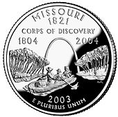
In October 1966, Gateway Arch National Park was added to the National Register of Historic Places as a Historic District . In 1987 the Gateway Arch was declared a National Historic Landmark . On August 4, 2003, as part of the State Quarters commemorative coin series, a 25-cent coin with a mintage of 453,200,000 pieces came out as a representative of the state of Missouri, which shows Lewis and Clark and the Missouri as well as the Gateway Arch. On July 21, 2007, around 200 visitors got stuck in the elevators due to an electrical problem with the car transport system. The next day there was another failure.
The annual number of visitors varies between 2 and 3 million:
| Annual visitor numbers 1980–1990 | |||||||||||
| year | 1980 | 1981 | 1982 | 1983 | 1984 | 1985 | 1986 | 1987 | 1988 | 1989 | 1990 |
| Visitors | 1,969,801 | 2,325,272 | 5,746,256 * | 6,369,640 * | 1,711,193 | 2,141,516 | 2,324,967 | 2,511,644 | 2,633,513 | 2,673,562 | 2,539,592 |
* = Number of visitors including the Veiled Prophet Fair
Since 2007 efforts have been made to architecturally upgrade the area of the Jefferson National Expansion Memorial. Work should be completed by October 28, 2015, the 50th anniversary of the completion of the Gateway Arch. The task of the ongoing competition is, among other things, to make the memorial more attractive to the urban structure of St. Louis, to liven it up with higher visitor numbers, to reduce the impact of traffic and to include the east bank in Illinois with the Gateway Geyser.
Buildings and facilities of the memorial
Gateway Arch
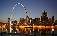
The Gateway Arch (also known as Gateway to the West ), modeled on a chain line , is 192 meters high and also has a span of 192 meters - this makes it the tallest structure in the city and the highest national monument in the United States. Its final form was created by the German-American civil engineer Hannskarl Bandel , who also improved Saarinen's construction.
The chain line of the Gateway Arch can be mathematically expressed by the equation of the hyperbolic function
,
with the constants
and
approximately describe. With this shape, the building is self-supporting and is under the necessary tension . However, a “real” chain line describes the shape of a chain suspended by gravity. Because of this, the Gateway Arch is just a flattened chain line of shape . An exact chain line would be the ideal solution for a curve with constant strength, which in this case does not exist. Therefore, the shape and construction of the “reverse chain line” and the transport system were a major challenge for the engineers. Kevin Roche commented:
“A chain line is first and foremost a line. When you put weight on it, it affects the weight of the arch shape and it creates a different line. But of course the arch is not a line, it has different cross-sections, so the loads change from top to bottom, and this change in weight is essential for the final shape of the chain line. "
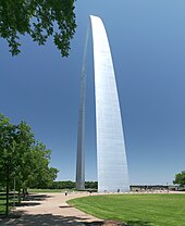
The Gateway Arch consists of a composite construction of concrete and stainless steel. The structure has a double-walled box girder cross-section made of steel, the floor plan of which is formed by an equilateral triangle . Above the foundations, the triangle has a side length of 16.46 meters with a wall thickness of 92 centimeters. Up to the top of the arch, the side length tapers to 5.18 m with a wall thickness of 21 centimeters. The entire arch consists of 142 such triangular segments. In the lower half the arch consists of a composite structure and in the upper part of a steel structure. The cladding is made of stainless steel and was supplied by Krupp . The concrete foundation weighs 23,569 tons. A total of 4,644 tons of steel were used in the arch. This results in a total mass of 39,214 tons for the structure.
In the keystone of the sheet is a time capsule inserted, which carries signatures of 762,000 students from St. Louis.
The viewing platform at the top of the arch is frequented by two special elevators - one in each half of the arch - every ten minutes. The elevator system, known as the Tram System , consists of eight cylindrical cabins that are arranged like a pearl necklace to compensate for the curvature of the arch. This ensures that the passengers always sit upright during the journey to the top. Five people can be transported per capsule at a speed of just under 4 km / h. This results in a transport capacity of 3500 people on an eight-hour day or up to 11,000 on a fourteen- hour day . The elevator system in the north arch was opened to the public on July 24, 1967, the one in the south arch was completed in 1968.
The 18 × 69 centimeter and 19 millimeter thick windows, 16 on each side, are inclined outwards and flush with the arch structure. The platform offers space for up to 140 visitors and, in good conditions, allows a foresight of over 55 kilometers. The view offers a view of the city of St. Louis and the surrounding St. Louis County as well as a view of southern Illinois to Cahokia . At wind speeds of 240 km / h, the bow moves around 46 centimeters from its rest position. There are two elevators for maintenance staff and emergency services that can accommodate up to twelve people. There is also an emergency staircase with 1076 steps.
Visitor center
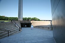
Directly below the Gateway Arch, a ramp leads from the outdoors into the underground visitor center. This center houses both the entrance for the drive to the apex of the arch and the Museum of Westward Expansion , which opened on August 10, 1976 . The cost of building the museum was $ 3,178,000. The museum has an exhibit on the history of the St. Louis waterfront. A 285-seat cinema shows a documentary about the construction of the Gateway Arch. Another cinema, completed in 1993, shows changing films.
The museum presents the entire history of the 19th century in the American West. The exhibits show the life of the people of that time during their expansion to the west. While the trip to the viewing platform is chargeable, a visit to the museum is free.
Park
The original park that houses the Gateway Arch, Visitor Center, and Museum was created by landscape architect Dan Kiley . Kiley chose wave-like shapes for the topography of the plant and followed geometric rules. Both the paths that run through the park and the shorelines of the two artificially created ponds are mostly asymmetrical in curved lines and correspond to the catenoid shape of the Gateway Arch. There are trees along the paths, around the ponds and in the service areas and planted bushes. The site is designed so that lines of sight run towards the Gateway Arch from both the ponds and the old courthouse . The current form of the facility has developed over the years, deviating from the initial plans, through many discussions between Kiley, Saarinen, the then Mayor of St. Louis Raymond Tucker and representatives of the National Park Service (NPS) to this concept. Originally, Kiley intended to make the system much more asymmetrical and to incorporate fewer lines of sight. It was not until spring 1963 that the revised concept, according to which the tree planting also had to be less dense, was approved by the NPS. Nowadays, the park is of great importance to preservationists and landscape architects and is considered a historical landscape worth preserving.
The southern pond has around 5400 square meters, the northern about 6800 square meters. There are over 2100 trees and over 7300 bushes in the park, which can be supplied via an irrigation system consisting of over 20 kilometers of underground pipelines. A total of around eight kilometers of footpaths run through the park.
In 2013, the groundbreaking ceremony for a multi-year project that will connect the park to the city via the main road was done. The street will be covered for around 300 m by 2015 and the park will continue above it.
Old Courthouse
The Old Courthouse ("Old Courthouse") is a representative building built in the Greek Revival style from 1816 to 1864, which originally served as a federal and regional court. The building was the venue of the historically significant trial of Dred Scott against Sandford , in which the black Dred Scott had sued for release as a slave .
The first structure was completed by the architect Henry Singleton in 1828. However, over the decades, the building has been redesigned and renovated several times and from the ground up. This work was directed by Robert S. Mitchell. It was not until 1861, during the American Civil War , that the dome was completed under the architect William Rumbold.
The courthouse is located west of Interstate 70 across from Gateway Arch. The more winged structure is dominated by a 58.5-meter-high domed structure rising centrally behind the main wing . The building remained the tallest in the state of Missouri until 1894 . The white wings of the building have triangular gable fields , similar to the Parthenon on the Acropolis . The front facade of the main wing is formed by six Doric columns .
The Old Courthouse has not served as a courthouse since 1930. Since 1935 it has served the then newly created Jefferson National Expansion Memorial. In 1941, parts of the building were renovated and, above all, its roof was renewed, so that from 1942 it could be used for office space and a museum exhibition. In the years 1947 to 1974 and 1978 to 1988 various other areas of the building were renovated in stages. On the second floor there are still two of the old courtrooms. The two circular rooms framed by columns are located in the west and east wings. Today the Old Courthouse dioramas depict the history of St. Louis from French settlement to the present day. With the completion of the Museum of Westward Expansion in 1976, the museum was also relocated. However, some dioramas and exhibits still remain in the courthouse today. The courthouse can be visited free of charge.
reception
The characteristic shape of the arch was found in buildings such as the Independence Arch in Accra and the Monument to the Friendship of Nations in Kiev.
The structure is shown on the 2003 Missouri State Quarter commemorative coin along with a scene from the Lewis and Clark Expedition .
literature
- Hélène Lipstadt: The Gateway Arch. Designing America's First Modern Monument in Eeva-Liisa Pelkonen, Donald Albrecht (Ed.): Eero Saarinen: Shaping the Future , Yale University Press. 2006, ISBN 978-0-300-11282-5 , pp. 222-229.
- N. Harris: Historic Photos of The Gateway Arch . Turner 2009, ISBN 978-1-59652-512-2 .
- Pierluigi Serraino: Eero Saarinen 1910–1961. A functional expressionist . Köln, Taschen Verlag 2005, ISBN 3-8228-2865-3 , pp. 26-29.
- René J. Brocard: L'arche symbolique de 192 m de hauteur et le stade en béton de 50,000 places de Saint-Louis , in: La Technique des Travaux , November 1967, no. 11–12 v. 43.
- W. Arthur Mehrhoff: The Gateway Arch. Bowling Green State University Popular Press 1992, ISBN 0-87972-567-2 .
Web links
- Cultural Landscape Report for Jefferson National Expension Memorial (pdf, English; 50.2 MB)
- Historical images and pictures of the construction of the Gateway Arch: 1 , 2
- National Park Service: Description of the Jefferson National Expansion Memorial (English)
- Site for architectural competition for the redesign of the site to the Jefferson National Expansion Memorial (English)
- www.gatewayarch.com (tourism site, engl.)
- www.nps.gov/jeff (official website, English)
Individual evidence
- ^ Hydro Dramatics: Gateway Geyser Renowned as Tallest Fountain in US and Spectacular Complement to the Arch
- ↑ a b Chapter I: 1933-1935: The Idea
- ↑ US Department of the Interior: Luther Ely Smith: Founder of a Memorial (PDF; 212 kB).
- ↑ Final General Management Plan and Environmental Impact Statement for Jefferson National Expansion Memorial: Appendices ( Memento of the original from October 16, 2011 in the Internet Archive ) Info: The archive link was automatically inserted and has not yet been checked. Please check the original and archive link according to the instructions and then remove this notice. (pdf)
- ↑ Serraino: Eero Saarinen 1910–1961, p. 27
- ↑ Aline B. Louchheim: For A Modern Monument: An Audacious Design in the New York Times, February 29, 1948
- ↑ Brown: Jefferson National Expension Memorial: The 1947-1948 Competition in Gateway Heritage
- ↑ Serraino: Eero Saarinen 1910–1961 , p. 28
- ^ Eero Saarinen to AF Schwartz on October 22, 1958 in Frank M. Karsten Papers , file No. 2599, WHMC.
- ^ Newspaper article in the St. Louis Globe Democrat on October 22, 1959
- ↑ Roger Ernst to Stuart Symington on February 11, 1959, Thomas C. Hennings, Jr. Papers, file No. 4930, WHMC
- ^ Jefferson National Expansion Memorial: Stabilizing Truss
- ↑ bid .; memorandum, Superintendent JNEM to Director NPS, November 13, 1965, JEFF. For information on the structural aspects: JEN Jensen A Steel Arch ... Symbol of the Spirit of the Pioneers , Civil Engineering, October 1965, pp. 64–69.
- ↑ Gateway Arch Facts ( Memento of the original from December 14, 2010 on WebCite ) Info: The archive link was inserted automatically and has not yet been checked. Please check the original and archive link according to the instructions and then remove this notice.
- ^ A b Jefferson National Expansion Memorial: Frequently Asked Questions
- ↑ Arch timeline ( Memento of the original from September 12, 2006 in the Internet Archive ) Info: The archive link was inserted automatically and has not yet been checked. Please check the original and archive link according to the instructions and then remove this notice.
- ↑ a b Appendix D: Chronology of Events Jefferson National Expansion Memorial
- ^ Unusual Events and Occurrences at Jefferson National Expansion Memorial
- ^ Jefferson National Expansion Memorial National Historic Site on the National Register Information System. National Park Service , accessed November 3, 2019.
- ↑ Laura Soullière Harrison: National Register of Historic Places Inventory-Nomination: Jefferson National Expansion Memorial Gateway Arch (pdf; 465 kB)
- ↑ Listing of National Historic Landmarks by State: Missouri. National Park Service , accessed August 16, 2019.
- ^ The Washington Post : Arch Runs at Half-Strength After Failure , July 22, 2007
- ↑ Appendix B: Annual Visitation Figures, 1980–1990
- ↑ stltoday.com: Jurors picked for Arch grounds competition ( Memento of the original from February 13, 2010 in the Internet Archive ) Info: The archive link was inserted automatically and has not yet been checked. Please check the original and archive link according to the instructions and then remove this notice.
- ↑ Competition Manuel (August 12, 2009) ( page no longer available , search in web archives ) Info: The link was automatically marked as defective. Please check the link according to the instructions and then remove this notice. (pdf; 6.8 MB)
- ^ Jefferson National Expansion Memorial: Mathematical Equation
- ↑ Graphical application for the computer algebra system Mathematica for the display and manipulation of the Jefferson National Expansion Memorial
- ^ Robert Osserman: Mathematics of the Gateway Arch , Notices of the American Mathematical Society 57, 2010, ISSN 0002-9920 , pp. 220-229.
- ↑ Serraino: Eero Saarinen 1910–1961 , p. 29
- ^ A b c Jefferson National Expansion Memorial: Gateway Arch Fact Sheet
- ↑ Leonard, Mary Delach in the St. Louis Post-Dispatch: Wow! At 40, shining Arch still is beacon to visitors ( Memento of the original from August 14, 2007 in the Internet Archive ) Info: The archive link was inserted automatically and has not yet been checked. Please check the original and archive link according to the instructions and then remove this notice.
- ^ Jefferson National Expansion Memorial: Tram System
- ↑ Newspaper report: The Gateway Arch A Historic Monument ( page no longer available , search in web archives ) Info: The link was automatically marked as defective. Please check the link according to the instructions and then remove this notice. (PDF; 1.0 MB)
- ^ Jefferson National Expansion Memorial: The Significance of the Gateway Arch Landscape
- ↑ Strategic Plan for Jefferson National Expansion Memorial ( Memento of the original from November 18, 2004 in the Internet Archive ) Info: The archive link was inserted automatically and has not yet been checked. Please check the original and archive link according to the instructions and then remove this notice.
- ↑ cityarchriver.org: Why are we doing this? ( Memento of the original from April 8, 2017 in the Internet Archive ) Info: The archive link was inserted automatically and has not yet been checked. Please check the original and archive link according to the instructions and then remove this notice.
- ^ Jefferson National Expansion Memorial: Old Courthouse Architecture
- ↑ Chapter V: Old Courthouse Rehabilitation and Restoration
