Hamburg-Kirchwerder
|
Kirchwerder district of Hamburg |
|
|---|---|
| Coordinates | 53 ° 25 '11 " N , 10 ° 12' 6" E |
| surface | 32.3 km² |
| Residents | 10,124 (Dec. 31, 2019) |
| Population density | 313 inhabitants / km² |
| Post Code | 21037 |
| prefix | 040 |
| district | Bergedorf |
| Transport links | |
| bus | 120, 122, 124, 222, 224, 422, 322, 323, 120, 223, 424, 225, 427, 227, 328 |
| Source: Statistical Office for Hamburg and Schleswig-Holstein | |
Kirchwerder ( Low German : Karkwarder , also: Kirchwarder ) is a Hamburg district in the Bergedorf district . It is the southernmost district and one of four parishes in the Vierlande .
geography
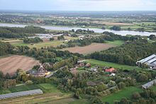
Due to its marshland soils, Kirchwerder is an exceptionally good vegetable growing area, but due to its location directly on the Elbe, it is at high risk of storm tides . Like the other four-country parishes, it is 800 years old and is one of the oldest preserved cultural landscapes in Germany.

history
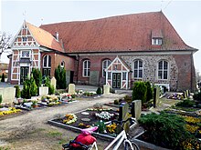
Today's four-country village Kirchwerder was originally called Remerswerder. The fact that it has been referred to in documents as Insula Kercwerdere - river island with church - since 1217 indicates the construction of a church. In fact, today's St. Severini Church is built on a field stone building from the 12th / 13th centuries. Century back; Remnants of the medieval walls are still preserved on the north wall of the current building. From the history of a dramatic incident is busy: 1470 are "more established citizens unknown reason their pastor have killed" - which is why the Pope temporarily the Great excommunication imposed on the village.
There is not much left to see of the medieval church, because from 1785 to 1791 there was a fundamental renovation in which only some parts of the wall from the previous building were reused. The bridal house , a half-timbered extension from 1649/50, in which the formalities of the marriage ceremony before the consecration in the church, was preserved. The current church is a single-nave hall with a wooden barrel vault, a large south wing and a five-sided choir closure; it has around 1,000 places.
The furnishings are largely classical. Ornate hat stands, which are typical of the four-country churches, mark the rows of benches of the men. The pulpit and baptism were made in 1806 by the Neuengammer Michael Busch. The altar, framed by two columns, the work of the Bergedorf master carpenter Radefahr, was already there for the re-inauguration in 1785.
The first settlement of the Elbe Islands, which later formed the Kirchwerder parish, cannot be proven. It is certain that Kirchwerder was one of the earliest dikes in the Vierlande, as a ferry connection across the Elbe between the Duchy of Braunschweig-Lüneburg and the new areas, which still exists today as the Zollenspieker ferry , was established here.
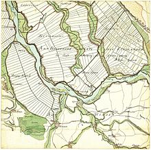
At the beginning of the 13th century, the Danes, who were then ruling in this region, began to dike the islands according to plan. From this period originates through the dike , which the new village church Werder against the adjacent, then not diked Ochsenwerder protected. Between 1314 and 1344 one of the Elbarme, the Gose Elbe , was forced into a solid bed by dykes. Two smaller Elbe islands, Ohe and Krauel , became mainland. West-Krauel became part of Kirchwerder, Ohe was divided between Kirchwerder and the neighboring parish of Neuengamme . Although this happened more than 650 years ago, the location and shape of both islands can still be clearly recognized by the names of places and streets as well as the shape of the farms.
The Elbe crossing was so important to the Lüneburg lords, to whom the area was subordinate, that they had a fortification built, which was first named as Riepenburg in 1296 and was the administrative seat of the Bailiwick of Riepenburg . The name came from the ruling family, the Lords of Ribe. In 1420 the castle became part of the two-city property : Hamburg and Lübeck had jointly taken control of the Lüneburgers. The damming and thus the "taming" of the Gose Elbe and the Dove Elbe (two arms of the Elbe that separated the islands of the Vierlande) made the castle superfluous. Since it was dilapidated, it was demolished in 1512 and the administrative headquarters moved to Bergedorf Castle . The remains of the castle hill can still be seen today when the Kirchwerder Mühlendamm and the main dike meet.
In 1620 the Lüneburgers tried unsuccessfully to regain the area through a military incursion; only Napoleon I was victorious there on his 1806 campaign. But even this did not change the administrative structure. In 1868 Hamburg bought the sovereign rights of Lübeck, so that the joint administration ended and the Vierlande - and thus Kirchwerder - belonged only to Hamburg. 1873 was the hitherto independent enclave East Krauel that belonged to the family of the Berghe was as independent municipality to Mansion shaft slammed mountain village. It was not until 1937 that the last six enclaves , which until then had been under Hanover and Prussian rule, were also incorporated into Bergedorf with the Greater Hamburg Act .
statistics
- Minor quota: 17.3% [Hamburg average: 16.3% (2017)].
- Old age quota: 20.0% [Hamburg average: 18.2% (2017)].
- Proportion of foreigners: 6.9% [Hamburg average: 17.1% (2017)].
- Unemployment rate: 2.1% [Hamburg average: 5.2% (2017)].
The average income per taxpayer in Kirchwerder is 39,284 euros annually (2013), the Hamburg average is 39,054 euros.
politics
For the election to Hamburg citizenship , Kirchwerder belongs to the constituency of Bergedorf . The 2020 citizenship election led to the following result:
| Citizenship election | SPD | CDU | Green | AfD | FDP | left | Rest |
|---|---|---|---|---|---|---|---|
| 2020 | 40.6% | 23.6% | 13.2% | 8.3% | 4.5% | 4.1% | 5.7% |
| 2015 | 48.7% | 23.5% | 7.3% | 6.6% | 6.5% | 4.5% | 2.9% |
| 2011 | 44.2% | 35.4% | 6.6% | - | 6.4% | 3.0% | 4.4% |
Culture and sights

Nature reserves
The Kirchwerder Wiesen nature reserve is located in Kirchwerder . The 860 hectare area is the largest nature reserve in Hamburg.
The Kiebitzbrack nature reserve is located on the border with the Neuengamme district near the Elbe dike . In the approximately 35 hectare area, there are several bracks created by dike breaches .
The Zollenspieker nature reserve is Hamburg's southernmost, located directly on the Elbe and around 80 hectares in size. It stretches from the Zollenspieker district via Ost- Krauel to the Neuengamme district .
St. Severini
The church dates from the 13th century and is surrounded by a large cemetery. It is often a place for readings and concerts, for example by choirs.
Riepenburg mill
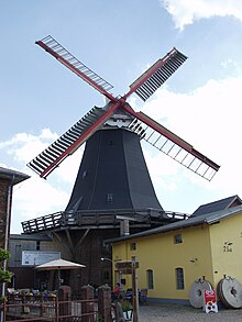
The Holländermühle Riepenburger Mühle is located at Kirchwerder Mühlendamm 75a and was baptized in 2006 with the name Boreas . The grain windmill, built in 1828, is the oldest and largest preserved mill in Hamburg. First mentioned in 1318, it is one of the oldest German windmills and is one of the last windmills in Germany to work regularly. It is a manufacturing technical monument.
Zollenspieker
Zollenspieker ( Low German : Tollenspieker, Op'n Spieker ) is a district of Kirchwerder and was an important ferry connection across the Elbe. It existed as early as 1252, then called "Yslinge", and is still in operation today. The customs house is already shown on Melchior Lorich's Elbe map and on a map by Daniel Frese from 1600.
Until 1806, until the conquest of the area by Napoleon I , customs were levied here (hence the name: "Zollenspieker" means something like "customs warehouse"), this was built on the kirchwerderan side at a point where the Elbe bends makes, because from here the Elbe and its own bank can be seen very well in all directions). The old granary was destroyed during the attack by the Lüneburgers in 1620, but was rebuilt a year later. A hill protects it from further attacks from the river to this day. From around 1870 the Zollenspieker became a tourist attraction for the people of Hamburg; the old customs warehouse was converted into a restaurant with a dance hall in a new extension and is still a popular destination today. It lies on the river kilometer 598 and also marks the southernmost point of the Hanseatic city.
From 1912 to 1953 had Zollenspieker a terminal station in which three small railway lines of Bergedorf-Geesthacht Railway ran together: the four-country train to Mountain Village (since 1912) and the Hamburg Marschbahn by Bill Brook (1928) and after Geesthacht (1921). The station area is now used as a festival or parking lot. The ferry to Hoopte in Lower Saxony is located on the banks of the Elbe on the opposite side of the Elbe.
Economy and Infrastructure
Agriculture
Since the Kirchwerder parish lies directly on the main river of the Elbe, it has been particularly hard hit by storm surges . Again and again dike breaches led to extensive flooding and thus to silting up of the soil. In addition, land was lost during these events due to the formation of bracks (deep erosion caused by turbulence behind the dike breaches). Farmers church Werder, traditionally grain grew, the not so good grows on sandy soils were characterized lower income than the farmers of the adjoining areas of the four-country.
From the end of the 17th century, the Kirchwerder farmers therefore began to grow the better-growing vegetables . Since, in contrast to the Bardowick vegetables, which were previously brought across the Elbe for the Hamburg supply, no customs had to be paid and the approach route was also significantly shorter, the Kirchwerder farmers were able to collect high profits. At the beginning of the 18th century the prices for the farms had risen significantly, and nowhere in the Vierlanden were there fewer bankruptcies by Kätnern , the poorest of the farmers, than in Kirchwerder. In the middle of the 19th century, the Kirchwerder villages of Sande (note the name!) And Varwisch were the most densely populated settlements in the region.
Since the farmers of the other four-country parishes also had sandy soils, albeit not as pronounced as in Kirchwerder, the cultivation of grain was soon given up in favor of growing vegetables. The Vierlande became Hamburg's vegetable chamber. When flower cultivation came up in the Vierlande at the end of the 19th century, Kirchwerder was least affected by the very good vegetable soil. To date, only a relatively few greenhouses can be found here.
schools
There are three schools in Hamburg-Kirchwerder.
Two primary schools: the Zollenspieker school and the Fünfhausen primary school .
The third school, the Kirchwerder school , is a primary school and a district school with an upper level. More than 1200 students are taught at the school.
It has existed as a “church school”, as an elementary school, for 125 years. In the early 1970s, many of the small surrounding primary schools closed their doors, and so the four countries had to send their children to the centrally located church school. Today the catchment area of this central school extends from Neuengamme in the east to Rothenburgsort in the west. A large proportion of the students can therefore only reach the school by bus .
In 1972, next to the old school building, a school building with class blocks, specialist rooms, a gym and a multi-purpose hall was built to meet the new needs. A sports field was added later.
Voluntary fire brigades
There are five volunteer fire brigades in Kirchwerder :
- The FF Kirchwerder-Nord is the second oldest fire brigade in Hamburg and is based in the oldest fire station in the city. (The first fire brigade in Hamburg, the Krauel volunteer fire brigade , was founded on October 15, 1877.)
- The FF Kirchwerder-Süd was founded in 1890.
- FF Fünfhausen
- FF Varvish
Personalities
- Hinrich Balemann (1692–1761), superintendent and consistorial councilor
- Heinrich Julius Tode (1733–1797), theologian, poet, mycologist and architect in Pritzier (Mecklenburg), later consistorial councilor in Schwerin
- Johann Clemens Tode (born June 24, 1736 in Zollenspieker, † March 16, 1806 in Copenhagen), professor of medicine in Copenhagen and writer
- Ferdinand Heinrich Grautoff (1789–1832), teacher in Lübeck, librarian and polyhistor
- Johann Heinrich Dräger (1847–1917), founder of the Drägerwerke in Lübeck
- Oskar Gundermann (1894–1968), physician
- Hertha Borchert (1895–1985), Low German writer, mother of Wolfgang Borchert (1921–1947)
- Jannik Schümann (* 1992), actor , musical actor and voice actor
See also
- List of streets and bridges in Hamburg-Kirchwerder
- List of cultural monuments in Hamburg-Kirchwerder
- Hammer-Hu
literature
- Achim Sperber: Vier- und Marschlande, land behind the dike . Hans Christians Verlag, Hamburg 1981, ISBN 3-7672-0734-6
- Culture Authority / Monument Protection Office Hamburg (Ed.): Vier- und Marschlande . Hans Christians Verlag, Hamburg 1986, ISBN 3-7672-0969-1
- Daniel Tilgner (Ed.): Hamburg from Altona to Zollenspieker. The Haspa manual for all districts of the Hanseatic city. Hoffmann and Campe, Hamburg 2002, ISBN 3-455-11333-8 .
- Otto A. Fischer: The Zollenspieker in Hamburg. History and stories . Förderverein Zollenspieker Fährhaus, Hamburg 1999, ISBN 3-00-005234-8
- Harald Richert: Old letters from Kirchwerder . In: Lichtwark booklet No. 74. Verlag HB-Werbung, Hamburg-Bergedorf 2009, ISSN 1862-3549
- Harald Richert: Hat stand - a specialty of the four-country churches . In: Lichtwark booklet No. 69. Verlag HB-Werbung, Hamburg-Bergedorf 2004, ISSN 1862-3549
Web links
Individual evidence
- ↑ Quota of minors in the Hamburg districts in 2017
- ↑ Proportion of 65-year-olds and older in the Hamburg districts in 2017
- ↑ Proportion of foreigners in the Hamburg districts in 2017
- ↑ Unemployment rate in the Hamburg districts in 2017
- ↑ Statistical Office for Hamburg and Schleswig-Holstein (ed.): Hamburg District Profile 2016 (= NORD.regional . Volume 19 ). 2018, ISSN 1863-9518 ( Online PDF 6.6 MB [accessed February 12, 2018]).
- ↑ election result in www.wahlen-hamburg.de
- ↑ Kirchwerder Wiesen on Commons
- ↑ Sven Baumung: A walk through the "Kirchwerder Wiesen" nature reserve . In: Lichtwark booklet No. 74, HB-Werbung publishing house, Hamburg-Bergedorf 2009, ISSN 1862-3549
- ↑ Nature reserves in Hamburg
- ↑ Kirchwerder Wiesen nature reserve on hamburg.de
- ↑ Kiebitzbrack nature reserve on hamburg.de
- ↑ Zollenspieker nature reserve on hamburg.de
- ↑ Map of the Zollenspieker nature reserve (PDF; 456 kB) on hamburg.de
- ↑ Riepenburger Mühle ( Memento of the original from April 2, 2008 in the Internet Archive ) Info: The archive link was automatically inserted and not yet checked. Please check the original and archive link according to the instructions and then remove this notice.
- ↑ Bergedorf Info
- ↑ FF Kirchwerder-Nord on feuerwehr-hamburg.de ( Memento of the original from July 20, 2014 in the Internet Archive ) Info: The archive link was inserted automatically and has not yet been checked. Please check the original and archive link according to the instructions and then remove this notice.
- ^ FF Krauel on feuerwehr-hamburg.de
- ↑ FF Kirchwerder-Süd on feuerwehr-hamburg.de ( Memento of the original from July 20, 2014 in the Internet Archive ) Info: The archive link was inserted automatically and has not yet been checked. Please check the original and archive link according to the instructions and then remove this notice.


