
Krasnoschtschokovo (Altai region)
| Village
Krasnoschtschokowo
Краснощёково
|
||||||||||||||||||||||||||||
|
||||||||||||||||||||||||||||
|
||||||||||||||||||||||||||||


Krasnoschtschokowo ( Russian Краснощёково ) is a village (selo) in the Altai region ( Russia ) with 5078 inhabitants (as of October 14, 2010).
geography
The village is located some 200 km in a straight line south-southwest of the regional administration center Barnaul in the foothills of the Altai on the left bank of whether -Nebenflusses Tscharysch .
Krasnoschtschokowo is the administrative seat of the Krasnoschtschokowski Rajons and the seat of the rural community Krasnoschtschokowski selsowet, which includes the village of Krasnoschtschokowo and the settlements of Malaya Sujetka, Tscharyschski and Semjonowka.
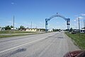
Entrance
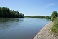
The Charysch near Krasnoschtschokowo


history
The village was founded in 1748. Since 1934 Krasnoschtschokowo has been the center of a Rajon.
Population development
| year | Residents |
|---|---|
| 1939 | 3280 |
| 1959 | 3403 |
| 1970 | 3947 |
| 1979 | 4585 |
| 1989 | 5501 |
| 2002 | 5506 |
| 2010 | 5078 |
Note: census data
traffic
Krasnoschtschokowo is located on the regional road in Smolenskoje from R368 Biysk - Belokurikha branches and north leads the mountain foot of the Altai to the west and in Kurja , the west adjacent and just over 30 km from Krasnoschtschokowo remote Rajonzentrum, the R370 Pospelicha - zmeinogorsk - Kazakh reaches limit . In Pospelicha, 70 km northwest of Krasnoschtschokowo, the nearest train station is on the Novosibirsk - Barnaul - Semei line .
Individual evidence
- ↑ a b Itogi Vserossijskoj perepisi naselenija 2010 goda. Tom 1. Čislennostʹ i razmeščenie naselenija (Results of the All-Russian Census 2010. Volume 1. Number and distribution of the population). Tables 5 , pp. 12-209; 11 , pp. 312–979 (download from the website of the Federal Service for State Statistics of the Russian Federation)
| Cities |
Aleisk S / R | Barnaul S | Belokuricha S | Biysk S / R | Gornjak R | Jarowoje S | Arrived on Ob R | Novoaltaisk S / R | Rubtsovsk S / R | Sarinsk S / R | Slavgorod S | Smeinogorsk R |
|
| Urban-type settlements |
Blagoveshchenka R | Yuzhny | Malinovoye Osero | Sibirski S / G | Stepnoje Osero | Talmenka R |
|
| Other Rajon centers |
Altayskoye | Bayewo | Burla | Bystry Istok | Chabary | Halbstadt | Yeltsovka | Kalmanka | Klyuchi | Kosicha | Krasnogorskoye | Krasnoschtschokovo | Kruticha | Kulunda | Kurja | Kytmanowo | Mamontowo | Mikhailovskoye | Novichikha | Novoyegoryevskoye | Pancrushikha | Pavlovsk | Petropavlovskoye | Pospelicha | Rebricha | Rodino | Romanowo | Zalessovo | Zavyalovo | Schelabolicha | Shipunovo | Smolenskoye | Solonezhnye | Solton | Sonalnoye | Sovetskoye | Staroaleiskoje | Tabuny | Tyumensevo | Togul | Topchikha | Troitskoye | Charyschskoye | Uglovskoye | Ust-Kalmanka | Ust-Charyschskaja Pristan | Werch-Sujetka | Volchikha | Tin buoy |