
Llama (Corsica)
| lama | ||
|---|---|---|
|
||
| region | Corsica | |
| Department | Upper Corsica | |
| Arrondissement | Calvi | |
| Canton | L'Île-Rousse | |
| Community association | L'Île-Rousse Balagne | |
| Coordinates | 42 ° 35 ' N , 9 ° 10' E | |
| height | 120-1,535 m | |
| surface | 19.92 km 2 | |
| Residents | 151 (January 1, 2017) | |
| Population density | 8 inhabitants / km 2 | |
| Post Code | 20218 | |
| INSEE code | 2B136 | |
 lama |
||

Lama is a municipality on the Mediterranean island of Corsica in France . It belongs to the Haute-Corse department , the Corte arrondissement and the L'Île-Rousse canton . It borders in the north on Urtaca , in the northeast on San-Gavino-di-Tenda , in the southeast on Sorio , in the south on Pietralba and in the west on Novella . The settlement area is about 480 meters above sea level.
Attractions
- Saint Laurent Church
- Chapel of San Lorenzo classified as a monument historique
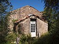
Chapel of San Lorenzo

Saint Laurent Church


Population development
| year | 1962 | 1968 | 1975 | 1982 | 1990 | 1999 | 2008 | 2012 |
|---|---|---|---|---|---|---|---|---|
| Residents | 249 | 237 | 174 | 120 | 98 | 130 | 176 | 164 |
Web links
Commons : Lama (Haute-Corse) - Collection of images, videos and audio files