
Landstetten (Starnberg)
|
Landstetten
City of Starnberg
Coordinates: 47 ° 59 ′ 11 ″ N , 11 ° 14 ′ 51 ″ E
|
|
|---|---|
| Height : | 689 m above sea level NHN |
| Area : | 2.8 km² |
| Residents : | 152 (2008) |
| Population density : | 54 inhabitants / km² |
| Incorporation : | May 1, 1978 |
| Incorporated into: | Starnberg |
| Postal code : | 82319 |
 Landstetten
|
|
Landstetten has been a district of the Upper Bavarian district town of Starnberg since it was incorporated on May 1, 1978 . Administratively, the church village previously belonged to its neighboring municipality of Perchting .
geography

Geographical location
Landstetten is located in the middle of the moraine landscape between Lake Ammersee and Lake Starnberg in the center of the Fünfseenland . The delightful landscape with its alternation of hills and valleys was created towards the end of the Würm glacial period through the thrust of the Isar-Loisach glacier .
Nature and landscape protection
Apart from the village all the corridors of the district Landstetten are within the conservation area, the Western part of the district Starnberg (LSG-00542.01), which was found in 1972 under protection. Parts of the landscape in the “Arena” corridor (Wagner hill) are designated as natural monuments .
From the village history
Early history

The burial mounds in the vicinity of the village with burials from the Hallstatt period suggest that the area around Landstetten was settled very early. A permanent settlement, however, probably only occurred in the first century AD after the conquest of the foothills of the Alps by the Romans and in the course of the construction of the Roman road Kempten-Gauting. The route of the country road, which leads past Landstetten (today district road STA 3), connected the two most important military and trade routes of the Roman Empire in southern Germany, the Via Claudia Augusta and the Via Julia .
In order to be better protected against attacks , strips of around 200 to 400 meters on both sides of a Roman road were cleared , depending on the topographical conditions. This reclaimed land was given to deserving legionnaires and civilians who moved to the area, who mainly built individual farmsteads there, cultivated the usable areas and provided riding and draft animals. A typical feature of Roman settlement is that these farms were not located directly on the country road, but a short spur road led to the settlement. Such an old cul-de-sac (St.-Jakob-Straße) exists in Landstetten. The original cell of the later Maierhof , from which the village developed, is therefore likely to have been a former Roman estate.
Early Middle Ages

Political and economic problems meant that the Romans had to give up their local province of Raetia in the course of the 5th century . A period of immigration followed, especially of Germanic tribes from the north and tribes from Bohemia, who, together with the remaining Roman population, formed the new ethnic group of the Bavarians . Preferred settlements were locations with already cleared land and paved roads. The settlement of the places whose names end in -stetten is dated to the time between 600 and 700. In the earliest documents Landstetten is referred to as "Antissteti", which means something like "home of a man named Anto". In later documents it becomes “Anstetten” and in 1501 the current name “Landstetten” appears.
Landstetten is mentioned for the first time in writing in a document dated April 16, 1010. Heinrich II , King of Eastern Franconia and Duke of Bavaria , transferred state property in Landstetten and seven other villages to the Polling monastery in Pfaffenwinkel, founded around 750 by the Huosi family .

For the rulers of the Middle Ages , the monasteries - at that time centers for pastoral care, medicine and studies, but also economic and administrative centers - were important partners for the reclamation and economic development of their territory . They provided the cultural bearers of that time with land ownership, which they gave to farmers as beneficial ownership in return for annual taxes in order to generate the income they needed for monastic work. In Landstetten, the foundation was an area of 2.8 square kilometers.
Early modern age
A homestead that went to Polling with the corridors of Landstetten is mentioned in a description of the subjects in the Weilheim district court in 1532: Jorg and Hanns Mair (be) pauen 1 Sedel Hof together, belongs to that of Pollingen. A Sedelhof was a privileged farm that had no flocking services and usually dates back to a very early period of origin. It was managed - at least once in its history - by an administrator (called "Maier") of a noble or ecclesiastical landlord . From this designation, the exit from the courtyard directly onto the original fields and the house name “Mayr” it can be inferred that it is the “original courtyard” of the settlement. The further development of the village can be traced back on the basis of documents and the land map from 1810.


The Sedelhof “Mayr” (yellow), house no. 7, was shared among brothers. This created “Baur”, house no. 6, which took over the fields marked in orange. Further cultivation of the agriculturally usable areas began after the fields of the Sedelhof. Initially by property no. 4, the "Häuselmann-Hof", located in the middle of the village and shown here in green, which - as can be deduced from the location of the fields - was also divided. Property no. 1 (blue), the Kopp-Hof, received its half. At each of these four courtyards of roughly the same size, the monastery allowed the construction of a sölde , the land ownership of which was irrelevant. Its residents earned their living as day laborers and craftsmen. With these eight properties and a house for the village shepherd , the development of the village was completed by the beginning of the 16th century at the latest.
Modern times
In 1790, 9 men, 9 women, 16 children, 10 servants and 11 maids lived in Landstetten in 9 households, who were represented by an elected local “captain yber die Gepaurschaff” in communal matters vis-à-vis the sovereign administration . At the beginning of the 19th century, Duke Maximilian IV underwent a comprehensive reorganization of the country. Linked to this was the dissolution of historically grown forms of organization. The property of the monasteries was expropriated and passed to the state. The manorial taxes, which were previously paid in kind by the Landstetten farmers, no longer went to Polling Monastery, but in guilders to the Rent Office in Starnberg.
In 1818 the formation of the cities and municipalities as independent communal units was completed. Since the population of Landstetten was too small to be allowed to form its own municipality, the place - although there was no common boundary between the districts - was added to the municipality of Maising . The fact that between 1824 and 1869 they appointed the mayor six times between 1824 and 1869 proves that the Landstetten residents, at least initially, had equal rights at the council table. In the 20th century, the citizens of Landstetten saw an administrative connection to the neighboring town of Perchting as the greater advantage, since their children went to school there and there was better transport links. After a number of petitions , on January 1, 1967, a government decision led to the reorganization. Another change in local political affiliation came into force on January 1, 1978. Due to the regional reform , both villages were incorporated into the city of Starnberg.
Culture and sights
St. James Church

Although legally part of Polling Monastery, the life of the farmers in Landstetten was strongly influenced by the Andechs Monastery, only five kilometers away . After a reliquary was found there at the end of the 14th century, a lively pilgrimage to the "Holy Mountain" began. Year after year parishes set out to be close to the saints venerated there and to ensure their intercession. One of the pilgrimage routes led from Munich via Gauting , Unterbrunn , Hadorf , Perchting and Landstetten to Andechs . In addition to the inns, the pilgrims also visited the churches in these places, which led to well-filled offering boxes . Proof of this is a letter from the Landstetten dated January 30, 1788 to Elector Karl Theodor . They ask for permission to rebuild their little church, which has become dilapidated over time, and disclose the finances they have saved for this purpose. As an argument that the further maintenance of the new church is also secured, they write:

... our place is on the way from Munich to Heil. Berge Andechs pilgrims have to pass and have so far always happened. On these occasions our little church is visited at all times, and productive sacrifices are always made, which so far have certainly contributed very much to its good fortune, and of which it is very likely that they will increase considerably if the pious generosity the pilgrim is also encouraged to contribute more by the sight of a new building.
On July 5, 1788, the electoral approval for the construction of the new church came. The Landstetteners had saved 379 guilders for their new building. However, this amount was only enough for the bricklayer's account. The construction of the building alone cost 671 guilders. Polling Monastery, under its art-loving provost Franz Töpsl , not only took over these additional costs, but also the costs for the re-casting of a bell and the considerable expenses for stucco and painting.
The drumlin beech


Typical of the landscape around Landstetten are drumlins , elongated hills made of rock rubble that the Isar-Loisach glacier left behind when it melted . On one of these hills there is a beech that is one of Germany's most famous trees. It is not only the long-term snapshot of the Bavarian Broadcasting Corporation, but also the tree of the seasons, which introduces the weekly BR program "Between Spessart and Karwendel".
Economy and Infrastructure

Landstetten is on the STA 3 district road. The town is connected to Starnberg ( Starnberger See ), Herrsching ( Ammersee ) and the Andechs monastery by bus lines .
There is a small private airport south of the village center. The “Landstetten external take-off and landing site” has a 527 meter long grass runway.
In the middle of the forest in the north of the village is the “Landstetten site shooting range” of the Bundeswehr. The facility is used for hand weapon training and first aid training.
The original village ensemble has changed little to this day. South of the old Roman road, two farms were built in the 1920s and, more recently, some residential buildings in the entrance area of the village. However, there has been a significant change in the use of agricultural land. With the settlement of a stud on the former Baur-Hof, which is dedicated to the breeding of Orlov trotters , Landstetten became a horse village and a large part of the former fields became meadows and pastures.
Sports
This means that driving plays a major role in Landstetten . Horse lovers meet here for tournaments and use the area as the starting and finishing point for the longest day trip in Europe, the Starnberger See Tour for two and more horses, which takes place every five years.
The second sporting component is air sports . The small airport is very popular with sports pilots from the region, and for passengers who love adventure, the balloon company based on the old Mayr-Hof offers trips over the Fünfseenland or the Alps.

Driving tournament at the Orlov stud

Landstetten balloon rides
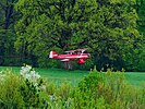
Approach to the Landstetten landing site


Web links
literature
- Anton Brunner: The old field names. Kulturverlag Stadt Starnberg, 2007, ISBN 978-3-940115-00-3 .
- Gertrud Rank, Michael Schmid: A piece of heaven. Art historical insights into the Starnberg church landscape. Kulturverlag Starnberg, 2008, ISBN 978-3-941167-03-2 .
- Catholic parish of Perchting with Hadorf and Landstetten. Kunstverlag Josef Fink, Lindenberg im Allgäu 2010, ISBN 978-3-89870-656-8 .
Individual evidence
- ↑ 8033-371 Moraine landscape between Ammersee and Starnberger See. (FFH area) Profiles of the Natura 2000 areas. Published by the Federal Agency for Nature Conservation . Retrieved November 25, 2017.
- ↑ Protected planet: western part of the Starnberg district , accessed on December 29, 2016.
- ↑ Benno C. Gantner: Settlement and urban development in the Peiting, Altenstadt and Schongau area in Der Welf 8-2004 / 2005 . Publisher: Historischer Verein Schongau Stadt und Land e. V., ISSN 0949-1716
- ^ Wolf-Armin von Reitzenstein : Lexicon of Bavarian place names ; Beck, Munich 1986; revised new edition with subtitle origin and meaning; Upper Bavaria , Lower Bavaria , Upper Palatinate . Verlag CH Beck, Munich 2006. ISBN 978-3-406-55206-9 .
- ↑ Bavarian Main State Archives , inventory designation BayHStA Kl. Polling Urk. 1 .
- ↑ Bavarian Main State Archive: Kurbayern Outer Archive 3928
- ↑ The old farms of Landstetten in the picture
- ↑ Leonhard Poelt: From Ascern and Musingin . Published by: Municipality of Pöcking, 1996
- ^ History of the pilgrimage to Andechs Monastery. Retrieved February 22, 2017
- ↑ G. Rank and M. Schmid pp. 54–56.
- ↑ The Drumlin Book of Landstetten on BR television , accessed on February 23, 2017.
- ^ Combat and disaster - Bundeswehr recruits reservists , accessed on March 9, 2017.

Buchhof | Einbettl | Fercha | Hadorf | Hanfeld | Heimathshausen | Jägersbrunn | Landstetten | Leutstetten | Mamhofen | Mühlthal | Oberdill | Percha | Perchting | Petersbrunn | Vineyards | Chimney | Schwaige | Selcha | Söcking | Sonnau | Starnberg | Lower horn | Cheeks | Wild moss