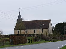
Larré (Orne)
| Larré | ||
|---|---|---|
|
|
||
| region | Normandy | |
| Department | Orne | |
| Arrondissement | Alencon | |
| Canton | radon | |
| Community association | Community Urbaine d'Alençon | |
| Coordinates | 48 ° 30 ' N , 0 ° 10' E | |
| height | 140-166 m | |
| surface | 5.67 km 2 | |
| Residents | 435 (January 1, 2017) | |
| Population density | 77 inhabitants / km 2 | |
| Post Code | 61250 | |
| INSEE code | 61224 | |
Larré is a French municipality with 435 inhabitants (as of January 1, 2017) in the department of Orne in the region of Normandy . Larré belongs to the Arrondissement of Alençon and the Canton of Radon (until 2015: Canton Alençon-3 ). The municipality is part of the communauté urbaine d'Alençon . The inhabitants are called Larrétois .
geography
Larré is about nine kilometers northeast of Alençon . The parish is part of the Normandy-Maine Regional Nature Park . Larré is surrounded by the neighboring communities of Ménil-Erreux in the north and east, Hauterive in the southeast, Semallé in the south and southwest and Écouves in the west.
Population development
| year | 1962 | 1968 | 1975 | 1982 | 1990 | 1999 | 2006 | 2013 |
|---|---|---|---|---|---|---|---|---|
| population | 210 | 206 | 257 | 326 | 365 | 384 | 403 | 423 |
| Source: Cassini and INSEE | ||||||||
Attractions
- Saint-Pierre church from the 17th century
- La Cour mansion
Web links
Commons : Larré - collection of images, videos and audio files

