
Majerovce
| Majerovce | |||
|---|---|---|---|
| coat of arms | map | ||

|
|
||
| Basic data | |||
| State : | Slovakia | ||
| Kraj : | Prešovský kraj | ||
| Okres : | Vranov nad Topľou | ||
| Region : | Šariš | ||
| Area : | 3.54 km² | ||
| Residents : | 445 (Dec. 31, 2019) | ||
| Population density : | 126 inhabitants per km² | ||
| Height : | 132 m nm | ||
| Postal code : | 094 09 ( Sedliská post office ) | ||
| Telephone code : | 0 57 | ||
| Geographic location : | 48 ° 53 ' N , 21 ° 43' E | ||
| License plate : | VT | ||
| Kód obce : | 528838 | ||
| structure | |||
| Community type : | local community | ||
| Administration (as of November 2018) | |||
| Mayor : | Ján Sarvaš | ||
| Address: | Obecný úrad Majerovce Sedliská 2 09409 Sedliská |
||
| Statistics information on statistics.sk | |||

Majerovce (until 1927 "Majorovce"; Hungarian Majoros ) is a small community in eastern Slovakia .

geography
The municipality of Majerovce is located near the ruins of Čičava Castle in the Ondava Valley , which enters the East Slovak lowlands from the Ondauer Uplands ( Ondavská vrchovina ) . The town of Vranov nad Topľou is only four kilometers away from Majerovce.
history
The place was first mentioned in a document in 1363. The Roman Catholic Church and the Greek Catholic Church were not built until the 1990s.
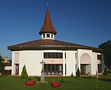
Roman Catholic Church

Greek Catholic Church


Transport links
Road 558 from Vranov nad Topľou to Humenné runs through the municipality. There is a railway connection in nearby Vranov nad Top Bahnou (railway line Prešov - Michalovce ).
statistics
The population of Majerovce consists almost exclusively of Slovaks . 80% of the population profess to the Roman Catholic Church , 19% stated that their denomination was Greek Catholic .
Individual evidence
- ↑ MOŠ statistics portal ( page no longer available , search in web archives ) Info: The link was automatically marked as defective. Please check the link according to the instructions and then remove this notice.