Nauendorf (Thuringia)
| coat of arms | Germany map | |
|---|---|---|

|
Coordinates: 50 ° 54 ' N , 11 ° 11' E |
|
| Basic data | ||
| State : | Thuringia | |
| County : | Weimar Country | |
| Management Community : | Crane field | |
| Height : | 335 m above sea level NHN | |
| Area : | 2.37 km 2 | |
| Residents: | 300 (Dec. 31, 2019) | |
| Population density : | 127 inhabitants per km 2 | |
| Postal code : | 99448 | |
| Area code : | 036209 | |
| License plate : | AP, APD | |
| Community key : | 16 0 71 059 | |
| Address of the municipal administration: |
In the village of 9 99448 Nauendorf |
|
| Website : | ||
| Mayor : | Marek Heusinger | |
| Location of the community of Nauendorf in the Weimarer Land district | ||

Nauendorf is a municipality in the south of the Weimarer Land district and part of the Kranichfeld administrative community .
geography
Nauendorf is located in the hill country of the Ilm-Saale-Platte about 16 km southeast of the state capital Erfurt and about 10 km west of Bad Berka . Due to its location, the Tonndorfbach meanders from Klettbach towards the neighboring town of Tonndorf . The closest heights are the Steinberg ( 449.4 m above sea level ) in the north, the Lattenberg ( 425 m above sea level ) in the northwest, the Galgenberg ( 402 m above sea level ) in the east and the Schwedenschanze ( 475.1 m above sea level) . NHN ) in the west.
traffic
The B 87 runs southeast of the village. The A 4 , which runs approximately five kilometers to the north, can be reached via the Erfurt-Ost connection and the A 71, which runs approximately 20 kilometers to the west, via the Arnstadt-Nord connection .
history
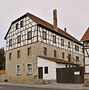
As Nuwendorf , the place is first mentioned in 1349 in the loan book of Landgrave Friedrich. Nauendorf has had its current name since 1554. In 1642, during the Thirty Years War, mercenaries raided and ravaged the village. A year later, 20 residents returned and tried a new beginning in the devastated village. In 1663 the population had risen to 58 again. The profitable cultivation of woad helped to overcome the consequences of the war. The convenient location between Erfurt and Kranichfeld (Handelsweg Erfurt - Saalfeld) as a gateway to the Thuringian Forest brought the residents additional income through accommodation, catering, horse-drawn animal care and other services for passing traders and craftsmen. The previous building ("Kurhaus") of the inn on the thoroughfare was probably built at this time.
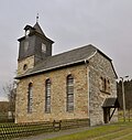
The church dates from the years 1829-1830, it was consecrated on November 8, 1830 with a festive service. The schoolhouse, newly built in 1840, was put into operation on November 6, 1840. The founding year of the volunteer fire brigade is 1883. In 1897 a new school building was necessary, which was completed in 1899. In the first years of the 20th century the Tonndorfbach was regulated and spanned with a first bridge at what was then the "Kurhaus". In 1967 the second bridge followed a little below the first. Nauendorf is electrified in 1926. In 1928 the Erfurt-Saalfeld gas pipeline was laid through the town, but the town itself was not connected. In 1945 American troops liberated the village, followed by occupation by Soviet troops. 1957 is the year of connection to a water supply, so the LPG could also go into operation in 1958, which lasted until 1990.
politics
Municipal council
The municipal council in Nauendorf consists of six council members who were elected in the local elections on May 25, 2014 in a majority vote, and the honorary mayor as chairman.
mayor
Mayor of the place is Eckard Brand, who was elected on December 6th, 2009.
Personalities
- Paul Franke (1881–1984), German publisher.
Attractions
In addition to a few old farmhouses, the place has three sights:
- Village church from 1829 to 1830
- Old hunting lodge , oldest building in the village
- Waldgasthaus and Hotel Stiefelburg . The inn is a popular excursion and hiking destination and is located on a mountain spur at about 455 m above sea level. NHN in the south-eastern neighborhood of the Quingerberg ( 480.2 m above sea level ) between Meckfeld and Nauendorf, about 1.8 km from Meckfeld. The property developed from a resting place at Zum Waldfrieden , which was built between 1928 and 1930 on the Stiefelberg , an old field name. In 1938 the rest house was converted into a restaurant with overnight accommodation. Stiefelburg was chosen as the name that still exists today . Largely unscathed, the property survived the World War and the time as a HO excursion restaurant.


