
Kauppen (Neuhof)
|
Kauppen
municipality Neuhof
Coordinates: 50 ° 27 ′ 13 ″ N , 9 ° 29 ′ 19 ″ E
|
|
|---|---|
| Height : | 472 m above sea level NHN |
| Area : | 1.99 km² |
| Residents : | 77 (Dec. 31, 2013) |
| Population density : | 39 inhabitants / km² |
| Incorporation : | December 31, 1971 |
| Postal code : | 36119 |
| Area code : | 06669 |
 The former fire station in the center of the village
|
|
Kauppen is a district of the municipality Neuhof in the district of Fulda in East Hesse in the state of Hesse in the Federal Republic of Germany .
geography
location
Kauppen is located 18 km southwest of the district town of Fulda on the south-eastern foothills of the Vogelsberg and, at 472 m above sea level, is the highest district of the Neuhof community. The height 504 is the highest point in the municipal area of Kauppen. The elevated water tank of the waterworks in the extended Winterbergstrasse is located on this contour line , while the residential development is at around 472 m. From here, when the weather is clear, there is a good view of the Hoherodskopf in the Vogelsberg, the Knüll , the Wasserkuppe in the Rhön and the Hessian ridge .
Neighboring places
Kauppen borders in the northeast on the Rommerz district of the Neuhof municipality, in the southeast on the Buchenrod district of the Flieden municipality , in the south on the Hintersteinau district of the town of Steinau an der Straße , in the southwest on the Reinhards (Freiensteinau) district in the west Weidenau of the municipality of Freiensteinau and in the north-west to the district of Hauswurz of the municipality of Neuhof in the so-called southern "Dreiländereck" of the district of Fulda. The three Hessian administrative districts of North Hesse , Central Hesse and South Hesse meet at the boundaries of the district .
history
Kauppen was mentioned for the first time in 1662 in an interest register of the Propstei Petersberg as the village of the Fulda office of Neuhof .
The name means "settlement on the hilltop" . At that time the place was part of the Flieden court. Ecclesiastically it was assigned to the parish houseleek .
- In 1605 the place was mentioned under the name Neueröder in the Turkish tax register of the prince abbey of Fulda .
- In 1787 Kauppen belonged to the abbey of Fulda , Oberamt Neuhof .
- In 1789 there were 10 farmers and 4 hüttner in Kauppen .
- In 1812 it was designated the daughter church of Houseleek.
- In 1881, because of a serious accident in Kauppen, the mayor at the time, Peter Lauer, set a wayside shrine on the corner of "Am Strauchweg / Winterbergstraße" (because of a lightning strike in an approaching storm that resulted in the death of his maid). The memorial shrine is still there today.
- In 1895 the village had 121 inhabitants.
- In 1910 there were 140 souls.
From 1914 the children of Kauppen attended the newly built school in Buchenrod .
World Wars 1914–1918 and 1939–1945
During the First World War , the village suffered four fallen soldiers who lost their lives in Russia and France .
Five casualties, including two in Russia , two in Yugoslavia and one in Romania , were recorded during World War II .
Water supply
The first aqueduct was built in 1919. The drinking water was pumped into the elevated tank built in 1924 by means of a wind turbine and led into the adjacent houses on a free slope . When there was no wind, there were bottlenecks in the water supply. As a replacement, a water extraction point was created at the spring overflow 300 meters from the village. The water for the animals was drawn from the 4 or 5 remaining deep wells with buckets and rope from a depth of 4–6 meters. Only after the Second World War was the wind turbine replaced by an electric motor. This resolved the water emergency. The water supply from 1919, which had meanwhile got on in years and which had more and more pipe breaks and thus water losses, was completely renewed in 1963 with state, district subsidies and fire insurance .
Establishment of a fire brigade
In 1924 the fire brigade was established with makeshift equipment. The fire extinguishing was only possible with a hydrant and appropriate hoses, which were kept in a wooden box in the local bakery . There was no fire station. It was not until 1960 that a TS 8 motorized sprayer with a trailer could be procured with the help of the state of Hesse and the district. The parking space was in a private garage. After Kauppen was incorporated into the community of Neuhof, a new fire brigade house was built in 1970/1972 with the citizens' own contribution. In 1974 a fire engine was procured. ! In 977, the Hessische Brandversicherung determined during an inspection that the required extinguishing water supply in the event of a house or barn fire was insufficient. For this reason, an additional extinguishing water cistern with a capacity of 100 cubic meters had to be built on the grounds of the playground, which was supported by the fire insurance.
Displaced persons
After the Second World War from 1945, Kauppen was in the American occupation zone of Greater Hesse . In 1946 the Fulda District Office assigned 20 displaced persons to the community. They came from the Sudetenland and came from Speierling in the Tachau district . Under Mayor Herbert, displaced families, some with children, had to be distributed among the large local families and their apartments. That wasn't just because the existing living space had to be divided. However, the new residents showed a willingness to help and help in agriculture.
Local sewerage
In 1950, depending on the financial situation of the municipality, the annual expansion of the sewer system (mayor's canals) began in Kauppen with manual and tension services for the citizens. The work was completed at the end of the 1950s. There were still no septic tanks or sewage treatment plants, these followed at a later date. Until then, the waste water that had accumulated was channeled into the domestic cesspool and distributed over the fields.
In 1999, the Neuhof municipality began the new construction measures to renew the sewer network and the connection of the Kauppener local facility to the Hauswurz sewage treatment plant in the upper Kemmetegrund on Sandweg.
school and education
At the beginning of the school year in 1955, the students from Kauppen no longer attended school in Buchenrod, but switched to houseleek. The reason for the repeated change of school was the shorter way to school and the church affiliation to the parish Hauswurz. In 1973 the district of Fulda took over the school sponsorship. The school in Hauswurz was closed and incorporated into the Neuhof Castle School. With the change of school, school education takes place in the schools in Neuhof. Since then, the pupils have been transported by school bus. The long walk to school to Buchenrod or Houseleek is a thing of the past.
Backhaus - children's playground
The bakery was no longer used by the citizens and was demolished in 1974 and a missing children's playground was set up in the same place .
Land consolidation
Together with the neighboring communities of Hauswurz , Buchenrod and Weidenau , land consolidation was started in Kauppen in 1959 and was concluded in 1969. During this time, the Fulda Cultural Office created a new network of paths with water. Larger parcels of land were created, which were easier to manage agriculturally. Old stone walls made of reading stones and field borders were leveled and used to fill the sports field .
traffic
Kauppen is connected to the regional road network at Neuhof via the district road K 91 (Winterbergstrasse) to the state roads L 3141 and L 3181. The A66 motorway with its two connections in Neuhof ensures this. The public transport with regular bus is from Kauppen out to Neuhof . The regional train station that connects to the ICE train station in Fulda is located in Neuhof .
Reorganization
On December 31, 1971, Kauppen was incorporated into the community of Neuhof as part of the regional reform in Hesse.
Mayor and Mayor
| title | Surname | from | to |
|---|---|---|---|
| mayor | Karl Lauer | 1966 | 1972 |
| Mayor | Karl Lauer | 1972 | 2000 |
| Mayor | Achim Krah | 2000 | 2016 |
| Mayor | Mathias singing | 2016 | til today |
During the regional reform in 1972, Karl Lauer, as the former mayor of Kauppen, became the first mayor . This was followed by the aforementioned citizens who stood for election for the village community in the local elections.
religion
Catholic religion
;_Hochkreuz_am_Ortseingang.JPG)
Kauppen belongs to the Catholic parish of St. Bartholomew Houseleek (Neuhof) , which is assigned to the pastoral association Christ Redeemer Flieden-Houseleek and thus to the diocese of Fulda .
Mary's Grotto
The grotto with the bell bearer for the angelus bell and the war memorial were created by the church painter Alois Schiffhauer after leveling work in autumn 1977 on the property belonging to the community. The tuff lava stones required for this were brought in from the vicinity of Magdlos.
The project was initiated by the Kauppenener local advisory board based on an idea by the mayor at the time, Karl Lauer, and with the citizens' own contribution . The community of Neuhof under Mayor Karl Heimüller (1960–1984) made the property available.
Warrior Memorial
The memorial was designed with a large boulder made of lava tuff . On the stone there is a bronze plaque on which the names of those who died in both world wars are recorded.
Infrastructure
Community facilities

the Marian grotto
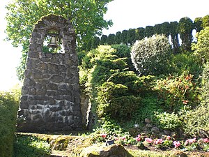
the bell bearer of the angelus bell at the Mariengrotte
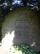
the war memorial at the Mariengrotto


A village community center has been set up in the former fire station , which existed until 1965, through the citizens' own contribution. A children's playground and a football field are available to the children and young people of the village .
Kauppen has its own water supply with spring tapping , pumping station and water tower and the sanitation of the wastewater treatment plant Hauswurz connected.
Individual evidence
- ^ "Kauppen, District of Fulda". Historical local dictionary for Hessen. (As of September 2, 2015). In: Landesgeschichtliches Informationssystem Hessen (LAGIS).
- ↑ Population statistics of the Fulda district , accessed in September 2015.
- ↑ Thomas Heiler: The Turkish tax register of the prince abbey of Fulda from 1605, (Publication of the Fuldaer Geschichtsverein in the Fuldaer Geschichtsbl Blätter; No. 64), Fulda, Parzeller-Verlag, 2004, ISBN 3-7900-0362-X , place register on pages 37– 47, from there reference to the page with the number of taxpayers
- ^ Federal Statistical Office (ed.): Historical municipality directory for the Federal Republic of Germany. Name, border and key number changes in municipalities, counties and administrative districts from May 27, 1970 to December 31, 1982 . W. Kohlhammer GmbH, Stuttgart and Mainz 1983, ISBN 3-17-003263-1 , p. 394 .