Potter County, Pennsylvania
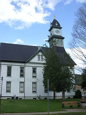
 Potter County Courthouse |
|
| administration | |
|---|---|
| US state : | Pennsylvania |
| Administrative headquarters : | Coudersport |
| Foundation : | March 26, 1804 |
| Made up from: | Lycoming County |
| Area code : | 001 814 |
| Demographics | |
| Residents : | 18,080 (2000) |
| Population density : | 6.5 inhabitants / km 2 |
| geography | |
| Total area : | 2801 km² |
| Water surface : | 1 km² |
| map | |
| Website : www.pottercountypa.net | |
Potter County is a county in the state of Pennsylvania in the United States . At the 2000 census , the county had 18,080 people and a population density of 6 people per square kilometer. The county seat is Coudersport . Potter County is named after James Potter , a general in the Continental Army during the American War of Independence against England.
geography
The county lies on the northern border with New York , has an area of 2801 square kilometers (of which one square kilometer is water) and borders clockwise on the counties: Allegany County (New York), Steuben County (New York), Tioga County , Lycoming County , Clinton County , Cameron County, and McKean County .
history
Potter County was formed on March 26, 1804, and finally organized in 1835. It is named after James Potter , a Pennsylvania general who served in the Continental Army during the American Revolutionary War.
Major Isaac Lymann, a veteran of the American Revolutionary War, was one of the first permanent settlers in the area and is the actual founder of Potter County. He paid ten dollars to every new settler willing to settle here. He also built the first road through the county, as well as the first flour mill and sawmill.

Five buildings and sites in the county are listed on the National Register of Historic Places (NRHP) (as of July 24, 2018).
Cities and towns
| Population development | |||
|---|---|---|---|
| Census | Residents | ± in% | |
| 1900 | 30,621 | - | |
| 1910 | 29,729 | -2.9% | |
| 1920 | 21,089 | -29.1% | |
| 1930 | 17,489 | -17.1% | |
| 1940 | 18,201 | 4.1% | |
| 1950 | 16,810 | -7.6% | |
| 1960 | 16,483 | -1.9% | |
| 1970 | 16,395 | -0.5% | |
| 1980 | 17,726 | 8.1% | |
| 1990 | 16,717 | -5.7% | |
| 2000 | 18,080 | 8.2% | |
| 1900-1990
2000 |
|||
Web links
Individual evidence
- ↑ Potter County in the United States Geological Survey's Geographic Names Information System . Retrieved February 22, 2011.
- ↑ Charles Curry Aiken, Joseph Nathan Kane: The American Counties: Origins of County Names, Dates of Creation, Area, and Population Data, 1950-2010 . 6th edition. Scarecrow Press, Lanham 2013, ISBN 978-0-8108-8762-6 , p. 249 .
- ↑ Search mask database in the National Register Information System. National Park Service , accessed July 24, 2018.
- ↑ Extract from Census.gov . Retrieved February 28, 2011.
- ↑ Excerpt from factfinder.census.gov.Retrieved February 28, 2011.
Coordinates: 41 ° 44 ′ N , 77 ° 54 ′ W

