
Sainte-Cécile (Manche)
| Sainte-Cécile | ||
|---|---|---|
|
||
| region | Normandy | |
| Department | Some | |
| Arrondissement | Saint-Lô | |
| Canton | Villedieu-les-Poêles | |
| Community association | Communauté de communes de Villedieu Intercom | |
| Coordinates | 48 ° 50 ′ N , 1 ° 11 ′ W | |
| height | 112-226 m | |
| surface | 11.29 km 2 | |
| Residents | 816 (January 1, 2017) | |
| Population density | 72 inhabitants / km 2 | |
| Post Code | 50800 | |
| INSEE code | 50453 | |
 Mairie Sainte-Cécile |
||

Sainte-Cécile is a French municipality with 816 inhabitants (as of January 1 2017) in the department of Manche in the region of Normandy . It belongs to the arrondissement of Saint-Lô and the canton of Villedieu-les-Poêles .
It is bordered by La Colombe to the north-west, Beslon to the north-east, Saint-Aubin-des-Bois to the east, Saint-Maur-des-Bois to the south-east, La Chapelle-Cécelin to the south, and Chérencé-le- Héron and to the west with Villedieu-les-Poêles-Rouffigny .
Population development
| year | 1962 | 1968 | 1975 | 1982 | 1990 | 1999 | 2008 | 2015 |
|---|---|---|---|---|---|---|---|---|
| Residents | 564 | 554 | 504 | 664 | 679 | 748 | 788 | 829 |
Attractions
- Chapelle de l'Acherie, former chapel
- Church of Sainte-Cécile

former chapel
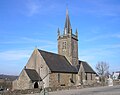
Church of Sainte-Cécile
.jpg)

Web links
Commons : Sainte-Cécile - Collection of images, videos and audio files