
Sierra de Guadarrama
| Sierra de Guadarrama | |
|---|---|
 Satellite map of the Sierra de Guadarrama |
|
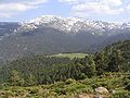
 Peñalara - highest point in the Sierra de Guadarrama |
|
| Highest peak | Peñalara ( 2430 msnm ) |
| location | Ávila , Guadalajara ( Spain ) |
| part of | Iberian Divisional Mountains |
| Coordinates | 40 ° 49 ′ N , 3 ° 57 ′ W |
The Sierra de Guadarrama is a maximum 2428 m high mountain range in central Spain , which forms the central part of the Iberian Scheidegebirge .
etymology
The Sierra de Guadarrama got its name from the Guadarrama river , which rises in the interior of the mountain range. The word Guadarrama comes from the Arabicوادي الرّمل / Wādī ar-raml , which means "river of sand" ( Wād = "river", raml = "sand"). The origin of the name shows the important influence the Arab-Moorish occupation from the 7th to 11th centuries had on this area.
geography
location
The Sierra de Guadarrama is located between the Sierra de Gredos in the Spanish province of Ávila and the Sierra de Ayllón in the province of Guadalajara . The mountain range extends from southwest to northeast, extends south into the province of Madrid , and has foothills to the north into the province of Segovia . The total length is about 80 km and reaches with the highest mountain Peñalara a height of 2428 m .
The proximity of the mountains to the capital Madrid has meant that it is now heavily overcrowded as a recreational area of the city. A multitude of passes and railway lines cross the Sierra de Guadarrama. The mountains are also used for sporting activities, as evidenced by the presence of several ski areas. The Sierra de Guadarrama played a major role in the history of Spain due to its proximity to the capital.


General data
The approximately 80 km long Sierra de Guadarrama runs from southeast to northeast and is part of the natural fault between the northern and southern Meseta . These form the central part of the Iberian Peninsula and the eastern part of the Iberian Dividing Mountains ( Sistema Central ). The foot of these mountains is at an altitude of 900 to 1200 m, the mean height of the most important mountains is around 1000 m. The highest mountain is the Peñalara with its almost 2430 m. The Sierra de Guadarrama begins in the valley of the Alberche river , which separates it from the Sierra de Gredos, and ends at the Somosierra pass, which serves as the watershed of the catchment areas of the Tajo and Duero rivers . The rivers Jarama , Guadarrama and Manzanares flow into the Tagus, and the rivers Duratón , Cega and Eresma into the Duero. The geographic coordinates of the north-eastern end of the Sierra are at 41 ° 4 'N 3 ° 44' E, the coordinates of the south-western end at 40 ° 22 'N 4 ° 18' E.
In addition to the main ridge, a tributary branches off the Sierra that runs in an east-west direction. It is called Cuerda Larga or Montes Carpetanos, although the second name is also used for the northern part of the main ridge, between Peñalara and Somosierra. This tributary begins at the pass of Navacerrada , is 15 km long and extends into the urban area of the capital Madrid . Until this branch reaches the pass of Morcuera, the imposing mountain range is nowhere lower than 2000 m. From here its height decreases to the mountain range of Patones , where the Lozoya and Jarama rivers converge. The highest mountain of the tributary Cuerda Larga is the Cabezas de Hierro with 2383 m.
Between the Cuerda Larga and the main mountain range of the Sierra de Guadarrama extends the Lozoya Valley (Valle del Lozoya), one of the best examples of a mountain valley in the Iberian Divisional Mountains (Sistema Central) . The valley is of great tourist importance, both in winter (mountain sports, skiing) and in summer. In addition to the main mountain range, there is another side range called La Mujer Muerta ("the dead woman") or Sierra del Quintanar. This side train begins at the Pass of Fuenfría (puerto de la Fuenfría) , runs from east to west and lies entirely in the province of Segovia . It is 11 km long and several of its mountains exceed 2000 m, including the Monton de Trigo ("Wheat Mountain").
In addition to the main mountain ranges Cuerda Larga and Mujer Muerta, there are various smaller mountain ranges and hills on the edge of the large mountains. In the province of Segovia , from north to south, there are the Cerro de las Cardosillas (1635 m), the Cerro de Matabueyes (1485 m), the Cerro del Caloco (1565 m) and the Sierra de Ojos Albos (1662 m) . On the side of the province of Madrid , from north to south, there are the Cerro de San Pedro (1423 m), the Sierra del Hoyo (1404 m), the Cerro Cañal (1331 m) and Las Machotas (1466 m).
mountains
The Sierra de Guadarrama is a range of hills with a gentle silhouette, i.e. without particularly protruding individual mountains, although there are of course exceptions. The following list shows the highest peaks of the Sierra de Guadarrama:
- Peñalara (2430 m), highest mountain in the entire Sierra de Guadarrama
- Risco de los Claveles (2387 m)
- Cabezas de Hierro (2383 m), highest mountain of the Cuerda Larga
- Risco de los Pájaros (2334 m)
- Dos Hermanas (2285 m)
- Cerro de Valdemartín (2280 m)
- Bola del Mundo, also: Alto de las Guarramillas (2265 m)
- Pandasco (2238 m)
- La Maliciosa (2227 m)
- El Nevero (2209 m), one of the northernmost mountains in the Sierra
- Montón de Trigo (2161 m), belongs to Mujer Muerta
- Siete Picos (2138 m)
- La Najarra (2108 m)
- Flecha (2078 m)
- Peña del Águila (2010 m)
- La Peñota (1945 m)
- Monte Abantos (1753 m), one of the southernmost mountains,
- El Yelmo (1717 m), the main mountain of La Pedriza
- Cerro de San Pedro (1423 m)
geology
The Sierra de Guadarrama was formed by the meeting of two tectonic plates , the southern sub-plateau and the northern sub-plateau, both of which belong to the Meseta (Meseta Central) of the Iberian Peninsula . The sierra was formed during the Alpine mountain formation in the Cenozoic (also known as the Earth New Age), which began around 65.5 million years ago; it is therefore much older than, for example, the Pyrenees , Alps , Andes or the Himalayas . The rock on which the Sierra rests (the granite pedestal of the Meseta) is older, and comes from the Variscan Orogeny during the Paleozoic (also known as the ancient times), when the continental collision led to the formation of Pangea from Laurasia and Gondwana . Because the rocks have been exposed to severe erosion since their formation , both the mountain peaks, known by miners as Cuerdas (“ropes”), and the northern and southern foothills are very flattened.
Emergence
During the Middle Paleozoic Era (360 to 290 million years ago), gneiss was formed by folds and metamorphosis from granite and sediments . During the Upper Paleozoic Era (290 to 250 million years ago) the gneiss was broken, which allowed magma to come to the surface, which hardened there and formed a plateau (meseta) with a granite base. During the Permian , in the last phase of the Paleozoic, the entire mountain range was raised by plate tectonics . Since the beginning of the Mesozoic Era (250 to 65 million years ago), and until today, the mountains have been removed and the silhouette flattened.
Also during this time, a shift in the oceans ensured that the sierra became part of an ocean (it is possible that today's mountains, as small islands, barely protruded above the surface of the water at that time). This created sedimentation basins in which lime later formed from the deposits . These are today on the edge and in the interior of the Sierra. Some of them can be seen in El Vellón , La Pinilla or in Patones .
During the Cenozoic Era, ie about 65 to 1.8 million years ago, the Sierra was raised again and divided into those blocks that we can still find today. Due to the erosion of the rock massif, the valleys were filled with sandstone. The glaciers of the Quaternary (Ice Age) (1.8 million years ago until today) left small cirques in the Sierra de Guadarrama as well as lakes and moraines formed by glaciers . Examples of this can be found on Mount Peñalara . The mountains El Nevero and La Maliciosa still show traces of the Ice Age. The geomorphology , as we find them today, was finally ended in the last million years. It was created through the effects of the glaciers, through the consolidation of rivers, and through the erosion of valleys and the formation of terraces.
history


The Torralba and Ambrona hills are about 150 km northeast of Madrid. On the opposite hills there was an old Paleolithic hunting ground from around 400,000 BC. The central part of the Sierra de Guadarrama belonged to the city of Segovia as early as Roman times, including all the forests and pastures on both sides of the mountain. Nevertheless, the Reconquista and the subsequent Repoblación of the Taifa Kingdom of Toledo (11th and 12th centuries) soon led to conflicts with Madrid and Guadalajara, which also claimed parts of the Sierra de Guadarrama. A strategically important point was the castle of Manzanares el Real , which belonged to the Ducado del Infantado from the Mendoza family.
In the 19th century, the division of Spain into provinces by Javier de Burgos laid down the division of the mountains between Madrid and Segovia. Since then, the summit of the Sierra de Guadarrama has been the border between New Castile and Old Castile .
As a natural barrier, this mountain range has been the scene of decisive battles in many wars and feuds. For centuries, the border between the Christian kingdoms in the north and the Muslim kingdoms in the south ran here. Medieval cities and their city walls have been preserved from this period, such as Buitrago de Lozoya near Madrid or Pedraza near Segovia, as well as castles such as that of Manzanares el Real .
Also in the Spanish war of independence against the French conquerors in 1808 the battle of Somosierra took place at a pass in the Sierra de Guadarrama . The Napoleonic troops, reinforced by Polish lancers , drove the Spanish defenders from the pass with heavy losses. To commemorate this decisive battle, which opened the way to Madrid for the French army, a monument was erected on the pass. The name "Somosierra" can also be found on the triumphal arch in Paris. During almost the entire Spanish Civil War , the Sierra de Guadarrama was a frontline area, and trenches and casemates are still preserved along the summit line . The Guadarrama pass was called “Alto de los Leones de Castilla” at the time of the Franco dictatorship to commemorate the attempt of the Falangist militias to capture the pass in 1936. The huge concrete cross in the Valle de los Caídos is a reminder of all these events.
Literature and art


The mountains have been mentioned in literature since the Middle Ages. In travelogues, the Serranas, rural shepherds, are portrayed as cruel by Juan Ruiz , and more bucolic or Italian by Íñigo López de Mendoza . In the 20th century, poets like Luis Rosales sought inspiration in the mountains. Lookouts were later set up bearing their names. The Sierra de Guadarrama is the main setting for the novel For Whom the Bell Tolls by Ernest Hemingway ; It depicts the struggle of republican guerrillas behind enemy lines during the Spanish Civil War .
The famous "Skies of Velázquez " are bordered by the peaks of the Sierra de Guadarrama. They form the background of the portraits of Philip IV , the Conde Duque de Olivares and Prince Baltasar Carlos . It was not until the landscape painting of the 19th century, for example by Carlos de Haes , that the mountains became an independent motif.
Major cities and villages
The Sierra de Guadarrama is surrounded by many villages, with a large number of holiday apartments, which are therefore mainly inhabited during the holiday season. Settlement pressure is particularly high in the southeastern part, which is close to the capital Madrid , as apartments near the Sierra are very popular and in demand with the residents of Madrid. The main towns in the Madrid region are San Lorenzo de El Escorial , Los Molinos , Guadarrama , Cercedilla , Navacerrada , Manzanares el Real , Miraflores de la Sierra , Alpedrete and Rascafría . In the province of Segovia , the most important localities are Los Angeles de San Rafael and the city of Segovia itself with the castles La Granja de San Ildefonso and the Palace of Riofrío . All of these villages are the starting point for at least one hiking trail along the mountain slopes of the Sierra; As tourist centers, they have hotels, restaurants and shops. Although all the communities are at the foot of the Sierra, they are all below 1200 m . When the weather is clear, the Sierra de Guadarrama forms the backdrop for the cities of Madrid and the closer Segovia.
fauna and Flora
The vegetation is characterized by an abundance of pine forests and a few oaks and holm oaks on the lower slopes. The peaks are characterized by low bush landscapes. The number of existing animal species is also large: u. a. this includes deer , roe deer , fallow deer , wild boar , badger , various types of weasels , European wildcats , hares, etc. The variety of ducks in the mountain lakes and reservoirs, as well as birds of prey is considerable. Well-known raptors are z. B. the Spanish imperial eagle and the black vulture . In 2013, much of the area was placed under protection with the establishment of the Guadarrama National Park .
See also
Picture gallery
North side of the Cabezas de Hierro in spring

View of the Bola del Mundo and La Maliciosa Navacerrada dam
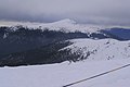
View of the Peñalara peak, the highest mountain in the Sierra de Guadarrama
View of the Siete Picos from the Valsaín valley

Holm oaks in winter with Monte Abanos in the background

La Maliciosa peak in winter

On the Eresma River

Typical pine forests in winter

El Escorial monastery residence , view of the entire complex


.jpg)
literature
- Jürgen Bogner: Sierra de Guadarrama. Hikes in the local mountains of Madrid. Bergverlag Rother, 2009. ISBN 978-3763343621 .
- Sierra de Guadarrama. Mapa-Guía. Ediciones La Libreria, 2013. ISBN 978-8498732146
Web links
- Official website of the Sierra de Guadarrama Natural Park (Spanish, English)
- Sierra de Guadarrama - Map and information (Peak excavator, English)