
Sulzberg (Oberallgäu district)
| coat of arms | Germany map | |
|---|---|---|

|
Coordinates: 47 ° 40 ' N , 10 ° 21' E |
|
| Basic data | ||
| State : | Bavaria | |
| Administrative region : | Swabia | |
| County : | Oberallgäu | |
| Height : | 711 m above sea level NHN | |
| Area : | 41 km 2 | |
| Residents: | 4949 (Dec. 31, 2019) | |
| Population density : | 121 inhabitants per km 2 | |
| Postal code : | 87477 | |
| Area code : | 08376 | |
| License plate : | OA | |
| Community key : | 09 7 80 140 | |
| Market structure: | 80 parts of the community | |
Market administration address : |
Rathausplatz 4 87477 Sulzberg |
|
| Website : | ||
| Mayor : | Gerhard Frey | |
| Location of the Sulzberg market in the Oberallgäu district | ||
  |
||


Sulzberg is a market in the Swabian district of Oberallgäu and is about ten kilometers south of Kempten (Allgäu) .
geography
location
The Allgäu Alps can be seen when looking to the south . The mountains Grünten , Großer Widderstein and Geißhorn can be seen most clearly.
Expansion of the municipal area
The municipality consists of the districts Sulzberg, Moosbach and Ottacker.
Sulzberg has 80 officially named parts of the municipality (the type of settlement is given in brackets ):
|
|
|
|
history
Early history
Sulzberg and Moosbach were first mentioned in a document in 1059. It is reported in a certificate from Emperor Heinrich IV of Sulzberg as "Sulceberch" and Moosbach as "Mosebach".
20th century
The war memorial was inaugurated in 1930.
On July 1, 1972, the once independent municipality of Ottacker ( Sonthofen district ) was incorporated. On the same day, the districts of Sonthofen and Kempten (Allgäu) were merged to form today's Oberallgäu district .
The incorporation of the former municipality of Moosbach came about on May 1, 1978. On this day there was also an area exchange with the community of Mittelberg, now Oy-Mittelberg . The Schlechtenberg solar park went into operation in 2013 .
Between 1988 and 2018 the municipality grew from 4,059 to 4,953 by 894 inhabitants or by 22%.
politics
mayor
Gerhard Frey was elected mayor on March 15, 2020. It was nominated by Free Voters Sulzberg, Moosbach Voters and Free Voters Graben-Öschle-See and received 55.74% of the vote.
His predecessor was Thomas Hartmann (CSU / Free Voters), in office from May 1996 to April 2020.
Municipal council
The municipal council has 16 members.
| CSU | Free voters | Moosbach flat share | WG Ottacker | FW Graben-Öschle-See | Alliance 90 / The Greens | total | |
| 2008 | 6th | 5 | 2 | 2 | 1 | - | 16 seats |
| 2014 | 5 | 5 | 3 | 2 | 1 | - | 16 seats |
| 2020 | 4th | 5 | 3 | 1 | 1 | 2 | 16 seats |
coat of arms
The blazon reads:
"Three times undulating divided by blue and gold."
The coat of arms of Sulzberg is based on the coat of arms of the Lords of Schellenberg .
Town twinning
Since 1990 there has been a partnership with the municipality of Chailland ( Mayenne department ) in France.
Architectural monuments
The well-preserved Sulzberg castle ruins are located about 500 meters south of the village and used to be the seat of the Lords of Schellenberg .
People in connection with the community
- Max Gasser (1872–1954), geodesist and photogrammeter
- Paul Kuën (1910–1997), tenor
- Alfons Hörmann (* 1960), entrepreneur and sports official, current DOSB President
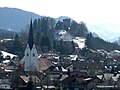
The place Sulzberg and the ruins Sulzberg
The fire brigade museum
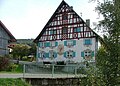
The mill in Aleuthe

Sulzberg ruins

Ried Ottacker
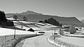
Winter landscape near Sulzberg


.jpg)
Web links
- Entry on the coat of arms of Sulzberg (Oberallgäu district) in the database of the House of Bavarian History
Individual evidence
- ↑ "Data 2" sheet, Statistical Report A1200C 202041 Population of the municipalities, districts and administrative districts 1st quarter 2020 (population based on the 2011 census) ( help ).
- ^ Community Sulzberg in the local database of the Bavarian State Library Online . Bayerische Staatsbibliothek, accessed on August 15, 2019 .. There incorrectly stated 81 parts of the municipality, because Auf'm Buch is listed twice.
- ^ Wilhelm Volkert (ed.): Handbook of Bavarian offices, communities and courts 1799–1980 . CH Beck, Munich 1983, ISBN 3-406-09669-7 , p. 496 .
- ^ Federal Statistical Office (ed.): Historical municipality directory for the Federal Republic of Germany. Name, border and key number changes in municipalities, counties and administrative districts from May 27, 1970 to December 31, 1982 . W. Kohlhammer, Stuttgart / Mainz 1983, ISBN 3-17-003263-1 , p. 795 .
- ^ Database of town twinning
- ↑ Sulzberg castle ruins (Sigmundsruh castle ruins)

Altusried | Bad Hindelang | Balderschwang | Betzigau | Blaichach | Bolsterlang | Buchenberg | Burgberg im Allgäu | Dietmannsried | Durach | Fishing in the Allgäu | Haldenwang | Immenstadt im Allgäu | Arbors | Missen-Wilhams | Obermaiselstein | Oberstaufen | Oberstdorf | Ofterschwang | Oy-Mittelberg | Rettenberg | Sonthofen | Sulzberg | Waltenhofen | Weitnau | Wertach | Wiggensbach | Wildpoldsried
Unregulated areas:
Kempter Wald