
Tiefenbach (Federsee)
| coat of arms | Germany map | |
|---|---|---|
.svg)
|
Coordinates: 48 ° 5 ' N , 9 ° 39' E |
|
| Basic data | ||
| State : | Baden-Württemberg | |
| Administrative region : | Tübingen | |
| County : | Biberach | |
| Height : | 588 m above sea level NHN | |
| Area : | 6.95 km 2 | |
| Residents: | 519 (Dec. 31, 2018) | |
| Population density : | 75 inhabitants per km 2 | |
| Postal code : | 88422 | |
| Area code : | 07582 | |
| License plate : | BC | |
| Community key : | 08 4 26 118 | |
| Address of the municipal administration: |
Buchauer Strasse 21 88422 Tiefenbach |
|
| Website : | ||
| Mayor : | Helmut Müller | |
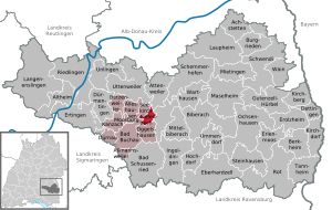
| Location of the municipality of Tiefenbach in the Biberach district | ||
  |
||


Tiefenbach is a small community in the Biberach district in Upper Swabia , located directly on the Federsee .
geography
location
The Tiefenbach district is located on the northeastern edge of the Federsee basin. In the west, the community has a share in the Federseeried. The village itself lies on the steep edge between the Federsee basin and the undulating old moraine area above.
Community structure
The community consists of the eponymous district Tiefenbach and has no other sub-locations. The hamlets of Streitberg and Maierhof, which formerly belonged to the municipality, came to the Stafflangen district of the city of Biberach an der Riss in 1977 .
history
The name of the community is first mentioned in 1277 as Tiuffenbach in connection with a family of local nobles. However, the origin of these multiple nobles is uncertain and nothing has been handed down from a castle in the village, so that the first sure mention of the community can be dated in 1353 ( Tuffenbach ).
Today's municipal area comprised a Maierhof owned by the Buchau women's monastery and around 30 cornelian bonds from the monastery. The monastery held the basic rule over Tiefenbach early on, the high and low jurisdiction and the Vogteirecht were with the rule Warthausen . The Maierhof was sequestered (confiscated) by Austria during the secularization of 1803 and came to the Kingdom of Württemberg in 1806 .
Tiefenbach was mentioned as early as the 15th century . To this day, the place has always been independent: it came to the Kingdom of Württemberg in 1806 , where it initially belonged to the Biberach Oberamt, and from 1809 to the Riedlingen Oberamt. In 1938 the community came to the district of Saulgau , when it was dissolved in 1973 to the district of Biberach .
Religions
The community is shaped by Roman Catholicism . Tiefenbach was mentioned in documents as early as 1353 as a branch of the Seekirch parish ( incorporated into the Marchtal monastery) . Even today the place belongs to the parish of the Assumption of Mary in Seekirch in the diocese of Rottenburg-Stuttgart .
After the Second World War, immigration resulted in a small Protestant minority. The Protestant Christians belong to the parish of Bad Buchau in the Riedlingen parish of the Evangelical Church in Württemberg .
politics
Administrative association
Tiefenbach has been part of the Bad Buchau community administration association since January 1, 1973 .
elections
Politically, Tiefenbach is traditionally Christian-conservative. In 1924, for example , the Center Party received 94.7% of the votes cast. In March 1933, the NSDAP received 57.9% of the vote and became the strongest party for the first time. Since the Second World War, the CDU has been strongly predominant (still in 1987 with 83.7%, but only 55.4% of the second votes in the 2005 Bundestag election).
coat of arms
Description of the coat of arms : Above a blue base of the shield, in it a silver fish, three cut green ears of wheat next to each other in gold, the sides inclined outwards.
In the coat of arms awarded in 1981, the ears of corn stand for agriculture, which characterizes the community image; the fish indicates the Federsee.
The flag of the municipality is green and yellow.
Attractions
- Chapel of St. Oswald , built in 1414 in Gothic style, modified in Baroque style in the 18th century . The furnishings include a late Gothic crucifix, a Pietà from around 1430, a seated Madonna and two figures of saints from the circle of Hans Multscher (around 1440), two figures of saints by Johann Joseph Christian (1745) and two paintings by Abraham van Diepenbeeck (17th century ) . Century).
literature
- Johann Daniel Georg v. Memminger: Tiefenbach municipality. , from description of the Oberamt Riedlingen . Cotta, Stuttgart and Tübingen 1827 ( full text at Wikisource )
- Paul Kopf: Seekirch, Alleshausen / Brasenberg, Tiefenbach . Federsee-Verlag, Bad Buchau 2007, ISBN 978-3-925171-69-7 ( table of contents )
Web links
Individual evidence
- ↑ State Statistical Office Baden-Württemberg - Population by nationality and gender on December 31, 2018 (CSV file) ( help on this ).

Achstetten | Alleshausen | Allmannsweiler | Altheim | Attenweiler | Bad Buchau | Bad Schussenried | Berkheim | Betzenweiler | Biberach an der Riss | Castles | Dettingen on the Iller | Dürmentingen | Dürnau | Eberhardzell | Erlenmoos | Erolzheim | Ertingen | Gutenzell-Hürbel | Hochdorf | Ingoldingen | Kanzach | Kirchberg an der Iller | Kirchdorf an der Iller | Langenenslingen | Laupheim | Maselheim | Mietingen | Mittelbiberach | Moosburg | Ochsenhausen | Oggelshausen | Riedlingen | Red on the red | Schemmerhofen | Schwendi | Seekirch | Steinhausen an der Rottum | Tannheim | Tiefenbach | Ummendorf | Unlingen | Uttenweiler | Wain | Warthausen