
Trpísty
| Trpísty | |||||
|---|---|---|---|---|---|
|
|||||
| Basic data | |||||
| State : |
|
||||
| Region : | Plzeňský kraj | ||||
| District : | Tachov | ||||
| Area : | 965.6186 ha | ||||
| Geographic location : | 49 ° 49 ' N , 13 ° 4' E | ||||
| Height: | 448 m nm | ||||
| Residents : | 258 (Jan. 1, 2019) | ||||
| Postal code : | 349 01 | ||||
| License plate : | P | ||||
| traffic | |||||
| Railway connection: | Pňovany – Bezdružice | ||||
| structure | |||||
| Status: | local community | ||||
| Districts: | 2 | ||||
| administration | |||||
| Mayor : | Josef Pavlas (as of 2007) | ||||
| Address: | Trpísty 18 349 01 Stříbro |
||||
| Municipality number: | 561291 | ||||
| Website : | trpisty.estranky.cz | ||||


Trpísty (German Trpist ) is a municipality with 258 inhabitants (as of January 1, 2019) in the Czech Republic . It is located 10 km northeast of Stříbro on the road to Úněšov at 448 m above sea level on a plateau above the valley of the Úterský potok.
geography
The place is located near the railway line from Pňovany to Bezdružice and has a stop one km southwest of the village. Two km southeast of Trpísty on the lower reaches of the Úterský potok begins the Hracholusky reservoir , a recreational area in which the Mies is dammed.
history
The first mention of the place comes from the year 1251. Trpist was the seat of a manor whose first owners were the Guttensteiner . They were followed by the Markwart von Hrádek, who united the former rule Welperschitz with Trpist at the beginning of the 17th century . The Schwanberger that in 1617 acquired the rule, eventually formed from their possession in Trpist and Triebl the manorial Trpist-Triebl that existed until the replacement of the patrimonial. Trpist was parish in Welperschitz.
Between 1723 and 1729, Prosper Anton Joseph Graf von Sinzendorf had Trpísty Castle built.
From 1938 to 1945 the place belonged to the district of Mies . In 1939 349 people lived in the village. On July 1, 1980 Trpísty was incorporated into Erpužice , since November 24, 1990 it is again an independent municipality.
Community structure
The municipality Trpísty consists of the districts and cadastral districts Trpísty and Sviňomazy ( Zwinomas ) with the residential area Horské Domky ( mountain houses ).
Attractions
The most important architectural monument is probably the Baroque Trpísty Castle, built according to plans by the Pilsen master builder Jakob Auguston instead of the Guttensteiner castle. Due to the loss of the palace archives in the 18th century, it is no longer possible to determine whether the building plans for the palace actually came from Auguston. The planner painter Wenzel Samuel Schmidt created the frescoes inside the castle between 1743 and 1744. The castle park was redesigned to an English landscape garden in the 19th century, and a female ginkgo tree is one of its valuable trees . Both the buildings and the park have been preserved in their original state, but they fell into disrepair after the expropriation of the castle owners during communist rule. In November 2002, the renovation of the castle began, which is an important cultural monument due to its originality.
In the Middle Ages there was a castle near Sviňomazy, the name of which is now forgotten. Since the 20th century, the complex, of which only an overgrown cone of debris is visible, has been called Sviňomazský Hrádek.
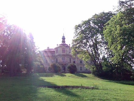
Trpísty Castle
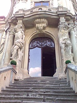
Trpísty Castle - garden portal

Trpísty Castle - fresco in the salon: Ambassador Count Joachim von Sinzendorf is in Constantinople from Amurat III. receive.

Trpísty, chapel on the village square


