
Tugam
|
Tugam
City of Luckau
|
|
|---|---|
 |
|
| Height : | 81 m above sea level NHN |
| Incorporation : | January 1, 1961 |
| Incorporated into: | Princely Drehna |
| Postal code : | 15926 |
| Area code : | 035324 |
Tugam ( Lower Sorbian Tugom ) is part of the municipality of Fürstlich Drehna , a district of the city of Luckau in the Dahme-Spreewald district in Brandenburg . Tugam belongs to the parish of Groß Mehßow.
location
Tugam is located in Niederlausitz in the Niederlausitzer Landücken nature park . The village of Gliechow , which fell victim to the Schlabendorf-Süd open-cast lignite mine in 1977, was located north of the village . Today, north of Tugam, there is a large open-cast mine that was flooded and forms the Drehnaer See . To the northeast lies Mallenchen , southeast Klein Mehßow , south Groß Mehßow , southwest Crinitz and northwest Fürstlich Drehna , whose part of the municipality is Tugam today. Tugam also has a small outbuilding to the northwest of the village.
Tugam is located on the northern slope of the Niederlausitz ridge in a mostly flat area. The Schrake brook, which flows through the district and the town itself, formed a narrow strip of bog centuries ago, which continued to Mallenchen. The Tugamer settlement was built on the west bank across from an approximately 120 m × 60 m piece of bog on the eastern bank of the Schrake. In addition to a few boggy soils in the lowlands, there is predominantly cultivated sandy soil (sand that is partly on clay marl or marl boulder).
Tugam has several large ponds where fish is farmed.
history

Nothing is known about the foundation of the town. It can be assumed that the place with the German colonization in the 12./13. Century was founded. The type of settlement is to be seen as an alley . The first written evidence is in the Lübben document book (part 3, page 87, note 3), where a Peter von Wildenhayn is named as the owner of Dugamm in 1447 . The loan book (Volume III, Sheet 138) lists Tugam on August 26, 1576. The place name of Tugam comes from the Slavic and means settlement of a man named Tugom , which indicates the history of ownership of the place.
Tugam belonged to the rulership of (Princely) Drehna at an early stage until it was expropriated in 1945. This has been documented in writing since 1576. The old village seal was lost in 1824, and in 1838 the community received a new one.
In 1816 there were 109 residents and 16 houses (fireplaces).
In 1900 the size of the district is given as 424 hectares , of which 241 hectares are accounted for in the village and 183 hectares in the Vorwerk (estate of Fürstlich-Drehna).
Mills
In the first centuries after its foundation, Tugam had its own water mill in the forest, the so-called Heidemühle . It was probably given up during or after the Thirty Years War , perhaps it was burned down as a result of acts of war (looting). The rushing water at the location of the former mill gave it the name Poltermühle later (around 1800) . There is only evidence of this in the church register Groß Mehßow, z. B. from the year 1600: The 12th of July Schyshev's son Johannes Tugom was baptized. Godparents. Hanß the Heidemüller, George Rautenstrauch the gross müller, and Regina Albin Niebels von Tugom's daughter.
Later the Groß-Mühle was responsible for Tugam, which was half on Tugamer and half on Groß Mehßower area.
Administrative affiliation
As a result of the Congress of Vienna , Tugam came to the Kingdom of Prussia in 1815 . On July 25, 1952, the community was assigned to the then newly formed Luckau district in the Cottbus district . On January 1, 1961, Tugams was incorporated into Fürstlich Drehna . After the reunification , Tugam was in the Luckau district in Brandenburg . For the district reform in Brandenburg on December 6, 1993 , Tugam was assigned to the newly formed district of Dahme-Spreewald . With the incorporation of Fürstlich Drehna to Luckau on December 31, 1999, Tugam became part of the municipality of Luckau.

The location of Tugam.
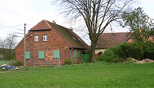
The former Mathen inn.

The Vorwerk in Tugam.


Pond management
There are several ponds, some of them very large, on the Tugamer Feldmark. The Brazil pond and the sand pond are the largest and oldest. In the 20th century, meadow areas west of the Brasenteich were dammed and flooded, creating two more ponds. A fifth pond was located south of the Brasenteich on the Groß Mehßower border. The last three ponds mentioned were drained as a result of mining and the resulting decline in water due to the lowering of the groundwater in the Schlabendorf-Süd opencast mine in the 1970 / 80s. After the open pit mining was closed in the 1990s, the two ponds that were drained by the Brasenteich were renatured again. They are 0.5 and 2.5 ha in size, the Brazil pond is 12 ha in size.

The reason for the creation of the ponds was mainly the fishing industry , but also the production of reeds to cover the roofs, in addition, designated areas served as cattle troughs for the cattle and the farmers. Fish farming was practiced centuries ago, in neighboring Groß Mehßow, for example, since 1527. The rulers of Fürstlich Drehna let brood carp in the small ponds of Babben and Pademag and the fish grew in the approximately 22 hectare brick pond in Fürstlich Drehna and in the Tugamer ponds then approach. Fish farming was profitable, and they even delivered to Berlin.
Until 1945 the fishing industry was operated by the rulership Fürstlich Drehna, then it was expropriated by the Red Army of the Soviet Union (occupation troops after the end of the Second World War ). A little later a fishing company was founded, which took over the management of the now abandoned ponds in the surrounding villages. Since 1952 it has belonged to the state-owned enterprise of the Peitz fishery - VEB inland fishery Peitz, Drehna division . After the end of the GDR in 1990, a trust administration took place. From the Fürstlich Drehna company, three shareholders founded the ecological pond management Fürstlich-Drehna GbR in 1992 . They now continue to farm fish, also in Tugam, and rebuild the two former ponds on the Brazilian pond.
While the ponds belong to the Peitzer Gesellschaft, they are leased by the Fürstlich Drehnaer Teichwirtschaft. Even today carp farming represents the main part, but pike, pikeperch and other fish are also bred. The resettlement of already extinct water dwellers, such as B. of the German noble crab and bitterling. Although these existed earlier, they were replaced by intensive carp farming in the GDR era. A small part of the fish is processed and marketed in-house.
- Tugamer sand pond
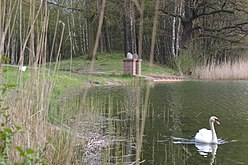
The Tugamer sand pond.

The sand pond (1973).

Ice hockey on the Tugamer Sandteich (2009).


Web links
literature
- Rainer Kamenz: The Groß-Mehßower parish - the Groß- and Klein-Mehßower village chronicle . 2016.
Individual evidence
- ↑ Reinhard E. Fischer : The place names of the states of Brandenburg and Berlin: age - origin - meaning . be.bra Wissenschaft, Berlin 2005, p. 171 . ( on Google Books )
- ^ Tugam in the historical index of places. Retrieved July 5, 2017 .
Districts:
Bergen |
Cahnsdorf |
Duben |
Egsdorf |
Freesdorf |
Princely Drehna |
Giessmannsdorf |
Görlsdorf |
Karche-Zaacko |
Kreblitz |
Kümmritz |
Paserin |
Rüdingsdorf |
Schlabendorf am See |
Terpt |
Uckro |
Wierigsdorf |
Willmersdorf-Stöbritz |
Zieckau |
Zöllmersdorf
Parts of the municipality: Alteno |
Caule |
Frankendorf |
Freiimfelde |
Garrenchen |
Kaden |
Pelkwitz |
Plaice |
Tugam |
Wittmannsdorf