Wittelsberg
|
Wittelsberg
Large community of Ebsdorfergrund
Coordinates: 50 ° 45 ′ 35 ″ N , 8 ° 51 ′ 17 ″ E
|
|
|---|---|
| Height : | 226 (219–248) m above sea level NHN |
| Area : | 6.88 km² |
| Residents : | 1015 (June 3, 2014) |
| Population density : | 148 inhabitants / km² |
| Incorporation : | April 1, 1972 |
| Postal code : | 35085 |
| Area code : | 06424 |

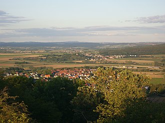
In the foreground Beltershausen , in the far background the 592 m high Rimberg
Wittelsberg is a district of the municipality Ebsdorfergrund in the east of the Central Hessian district of Marburg-Biedenkopf . The place has around 1000 inhabitants.
Geographical location
Wittelsberg is approx. 8 km southeast of Marburg . The settlement is located on the southern edge of the Amöneburg basin to the Vorderen Vogelsberg , on the edge of the catchment area of the Zwester Ohm , which is fed by the Wittelsberg Bach, which flows through the village from the east and which then flows off to the southwest. Immediately to the east and north of the village runs the watershed to the Ohm , which finally runs as a flat threshold north-west of the Kirchberg towards Moischt and from the east of the village over the Vorderen Vogelsberg to the actual Vogelsberg in the southeast, where the Ohm rises. The Kirchberg is a hill made of tuff rock , which, only 300 m northwest of the village center, towers over it by around 30 m. The Wittelsberger Warte built on the Kirchberg forms the symbol of the village as well as the coat of arms of the large community.
In terms of its structural layout, Wittelsberg is a closed village with an irregular floor plan. Half-timbered houses, including various farms, dominate the old village center; In the south of the village there is a modern housing estate. In the center of the village, streets from the neighboring towns of Schröck , Moischt , Heskem and Rauischholzhausen meet. The bypass of the Fronhausen - Kirchhain state road was not completed until 2006 , so that the volume of traffic in the village has noticeably reduced. In addition to two exits from the state road, only Moischter Straße leads regularly from the outside into the village. In contrast, the former streets of Heskem and Rauischholzhausen have now been converted into hiking and agricultural trails.
history
The place was first mentioned in a document around 1130 under the name Widdelesbere . There followed further mentions under different names Wydelberg (1243), Wihttelesber (around 1248), Wittilsberg (1267), Withelesberg (1267) and finally Wittelsberg (1577).
The place originally belonged to the Vogtei Ebsdorf , before whose Vogtgericht still decided in 1480 disputes about properties in Wittelsberg. Since 1867 the place belonged to the jurisdiction of the district court of Marburg . On April 1, 1972 Wittelsberg was incorporated into the municipality of Ebsdorfergrund.
In the Middle Ages, the street ran through the northern Lange Hessen from the Straßmühle near Hachborn to the Brücker Mühle near Amöneburg and Kirchhain .
Territorial reform
In the course of the regional reform in Hesse , the municipality of Wittelsberg was incorporated on April 1, 1972 into the Ebsdorfergrund municipality, which was newly formed on December 31, 1971 from the municipalities of Dreihausen and Heskem.
Territorial history and administration
The following list gives an overview of the territories in which Wittelsberg was located and the administrative units to which it was subordinate:
- before 1567: Holy Roman Empire , Landgraviate of Hesse , Frauenberg court (Frauenberg court consisted of the following locations: Wittelsberg as the place of jurisdiction, Beltershausen, Bortshausen and Moischt)
- from 1567: Holy Roman Empire, Landgraviate Hessen-Marburg , Marburg Office , Frauenberg Court
- from 1592: Holy Roman Empire, Landgraviate Hessen-Marburg, Kirchhain office , Frauenberg court
- 1604–1648: Holy Roman Empire, disputed between Landgraviate Hessen-Darmstadt and Landgraviate Hessen-Kassel ( Hessian War )
- from 1648: Holy Roman Empire, Landgraviate Hessen-Kassel, Kirchhain office, Frauenberg court
- from 1803: Holy Roman Empire, Electorate of Hesse , Kirchhain office, Frauenberg court
- from 1806: Electorate of Hesse, Kirchhain office, Frauenberg court
- 1807–1813: Kingdom of Westphalia , department of Werra , district of Marburg , canton of Amöneburg
- from 1815: German Confederation , Electorate of Hesse, Kirchhain office, Frauenberg court
- from 1821: German Confederation, Electorate of Hesse, Province of Upper Hesse , District of Marburg (separation of justice ( district court Marburg ) and administration)
- from 1848: German Confederation, Electorate of Hesse, Marburg district
- from 1851: German Confederation, Electorate of Hesse, Province of Upper Hesse, District of Marburg
- from 1866: North German Confederation , Kingdom of Prussia , Province of Hesse-Nassau , District of Kassel , District of Marburg
- from 1871: German Empire , Kingdom of Prussia, Province of Hessen-Nassau, District of Kassel, District of Marburg
- from 1918: German Empire, Free State of Prussia , Province of Hessen-Nassau, Administrative Region of Kassel, District of Marburg
- from 1944: German Empire, Free State of Prussia, Province of Kurhessen , District of Marburg
- from 1945: American zone of occupation , Greater Hesse , Kassel district, Marburg district
- from 1949: Federal Republic of Germany , State of Hesse , Kassel district, Marburg district
- 1974: Federal Republic of Germany, Land Hessen, Kassel , Marburg-Biedenkopf
- from 1981: Federal Republic of Germany, State of Hesse, Gießen district, Marburg-Biedenkopf district
Courts since 1821
With an edict of June 29, 1821, administration and justice were separated in Kurhessen. Now judicial offices were responsible for the first instance jurisdiction, the administration was taken over by the districts. In Marburg, the district of Marburg was set up for administration and the Marburg district court was the court of first instance responsible for Wittelsberg. In 1850 the regional court was renamed the Marburg Justice Office. The Supreme Court was the Higher Appeal Court in Kassel . The higher court of Marburg was subordinate to the province of Upper Hesse. It was the second instance for the judicial offices.
After the annexation of Kurhessen by Prussia, the Marburg district court became the royal Prussian district court of Marburg in 1867 . In June 1867, a royal ordinance was issued that reorganized the court system in the areas that belonged to the former Electorate of Hesse. The previous judicial authorities were to be repealed and replaced by local courts in the first, district courts in the second and an appeal court in the third instance. In the course of this, on September 1, 1867, the previous judicial office was renamed the Marburg District Court. The courts of the higher authorities were the Marburg District Court and the Kassel Court of Appeal .
With the entry into force of the Courts Constitution Act of 1879, the district court continued to exist under his name. In the Federal Republic of Germany, the superordinate instances are the Marburg Regional Court , the Frankfurt am Main Higher Regional Court and the Federal Court of Justice as the last instance.
Culture and sights
Buildings
Wait
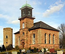
The Wittelsberger Warte from 1431, a round tower with rampart and moat right next to the parish church, which has been preserved as a ruin , was used by the Hessian landgraves to monitor the long Hesse trunk road running through the town . Landgrave Ludwig I had the control room built as the extreme border of the Hessian power, as an outpost for Frauenberg Castle near Beltershausen . From here the attempt was made to defend against the Catholic Kurmainz after the territorial battles were over. The fortress tower with a high entrance has slit-shaped, vertical loopholes for the use of crossbows . From the elevated position on the Kirchberg, the view extends far over the area of the Ebsdorfergrund community . The watch tower, which is one of the oldest structures in Ebsdorfergrund, is popularly known as "the Schanze".
Parish church
The Protestant parish church was built on the Kirchberg in 1844, right next to the medieval observatory. In connection with the medieval watch tower, it offers the image of a knight's castle rising from the plain to the north and east. An arcade made of hornbeam leads above the village up the hill to the church.
societies
There are several clubs in the village, including the volunteer fire brigade, a choir, a sports club, a shooting club, a poultry breeding club, a beautification club and the village community.
Infrastructure
There is a primary school in Wittelsberg.
literature
- Literature on Wittelsberg in the Hessian Bibliography
- Search for Wittelsberg in the archive portal D of the German Digital Library
Web links
- Wittelsberg district. In: Internet presence. Ebsdorfergrund community
- Wittelsberg, Marburg-Biedenkopf district. Historical local dictionary for Hessen. In: Landesgeschichtliches Informationssystem Hessen (LAGIS).
- Historical views of Wittelsberg in the photo archive Photo Marburg
Individual evidence
- ↑ a b Wittelsberg, Marburg-Biedenkopf district. Historical local dictionary for Hessen. (As of January 17, 2017). In: Landesgeschichtliches Informationssystem Hessen (LAGIS).
- ↑ The district on the website of the municipality of Ebsdorfergrund , accessed in August 2015
- ↑ a b Federal Statistical Office (ed.): Historical municipality register for the Federal Republic of Germany. Name, border and key number changes in municipalities, counties and administrative districts from May 27, 1970 to December 31, 1982 . W. Kohlhammer, Stuttgart / Mainz 1983, ISBN 3-17-003263-1 , p. 403 .
- ^ Michael Rademacher: German administrative history from the unification of the empire in 1871 to the reunification in 1990. State of Hesse. (Online material for the dissertation, Osnabrück 2006).
- ^ Georg Landau: Description of the Electorate of Hesse . T. Fischer, Kassel 1842, p. 370 ( online at HathiTrust's digital library ).
- ↑ The affiliation of the Kirchhain office based on maps from the Historical Atlas of Hesse : Hessen-Marburg 1567–1604 . , Hessen-Kassel and Hessen-Darmstadt 1604–1638 . and Hessen-Darmstadt 1567–1866 .
- ^ Kur-Hessischer Staats- und Adress-Kalender: 1818 . Publishing house d. Orphanage, Kassel 1818, p. 115 ( online at Google Books ).
- ↑ Ordinance of August 30th, 1821, concerning the new division of the area , Annex: Overview of the new division of the Electorate of Hesse according to provinces, districts and judicial districts. Collection of laws etc. for the Electoral Hesse states. Year 1821 - No. XV. - August., ( Kurhess GS 1821) pp. 223–224 .
- ↑ Latest news from Meklenburg / Kur-Hessen, Hessen-Darmstadt and the free cities, edited from the best sources. in the publishing house of the GHG privil. Landes-Industrie-Comptouts., Weimar 1823, p. 158 ff . ( online at HathiTrust's digital library ).
- ↑ Ordinance on the constitution of the courts in the former Electorate of Hesse and the formerly Royal Bavarian territories with the exclusion of the enclave Kaulsdorf from June 19, 1867. ( PrGS 1867, pp. 1085-1094 )
- ↑ Order of August 7, 1867, regarding the establishment of the according to the Most High Ordinance of June 19 of this year. J. in the former Electorate of Hesse and the formerly Royal Bavarian territorial parts with the exclusion of the enclave Kaulsdorf, courts to be formed ( Pr. JMBl. Pp. 221–224 )


