Xaçmaz (Rayon)

from Wikipedia, the free encyclopedia
Şəki Abşeron Sumqayıt Baku Xızı Siyəzən Quba Quba Şabran Xaçmaz Qusar Qobustan Şirvan Hacıqabul Salyan Neftçala Lənkəran Lənkəran Astara (Rayon) Lerik (Rayon) Yardımlı (Rayon) Cəlilabad (Rayon) Masallı (Rayon) Biləsuvar (Rayon) Sabirabad (Rayon) Saatlı İmişli (Rayon) Kürdəmir (Rayon) Şamaxı (Rayon) Ağsu (Rayon) Göyçay (Rayon) Ucar (Rayon) Beyləqan (Rayon) Ağcabədi (Rayon) Bərdə (Rayon) Zərdab (Rayon) İsmayıllı (Rayon) Qəbələ (Rayon) Ağdaş Yevlax (Stadt) Mingəçevir Yevlax (Rayon) Naftalan Göygöl (Rayon) Gədəbəy (Rayon) Samux (Rayon) Gəncə Şəmkir (Rayon) Tovuz (Rayon) Ağstafa (Rayon) Qazax (Rayon) Oğuz (Rayon) Şəki (Rayon) Qax (Rayon) Zaqatala (Rayon) Balakən (Rayon) Şəmkir (Rayon) Goranboy (Teile de-facto Republik Bergkarabach) Daskesan (Teile de-facto Republik Bergkarabach) Terter (Teile de-facto Republik Bergkarabach) Agdam (Teile de-facto Republik Bergkarabach) Xocavend (Teile de-facto Republik Bergkarabach) Füzuli (Teile de-facto Republik Bergkarabach) Kelbecer (fast vollständig de-facto Republik Bergkarabach) Xankəndi (unter der Bezeichnung „Stepanakert“ de-facto Teil der Republik Bergkarabach) Cabrayil (de-facto Republik Bergkarabach) Xocali (de-facto Republik Bergkarabach) Susa (de-facto Republik Bergkarabach) Lacin (de-facto Republik Bergkarabach) Qubadli (de-facto Republik Bergkarabach) Zengilan (de-facto Republik Bergkarabach) Ordubad (Teil der Autonomen Republik Nachitschewan) Culfa (Teil der Autonomen Republik Nachitschewan) Naxcivan (Teil der Autonomen Republik Nachitschewan) Babek (Teil der Autonomen Republik Nachitschewan) Sahbuz (Teil der Autonomen Republik Nachitschewan) Kangarli (Teil der Autonomen Republik Nachitschewan) Serur (Teil der Autonomen Republik Nachitschewan) Saderak (Teil der Autonomen Republik Nachitschewan)
Location of Xaçmaz Rayon in Azerbaijan

Xaçmaz , also Khachmaz , is a rayon in northern Azerbaijan . The capital of the district is the city of Xaçmaz . The district borders Dagestan , Russia , to the north .

geography

The district has an area of ​​1048 km². In the east the region is bounded by the Caspian Sea , in the west the Greater Caucasus begins . The land belongs to the Samur Devechi level. There are several mineral and thermal springs. The Gudial River flows through the district.

population

In 2009, 158,800 people lived in the rayon. These are spread over 26 settlements.

economy

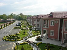
Hotel complex in Nabran on the Caspian Sea

The region is dominated by agriculture. Vegetables, fruits and cereals are grown. In the capital is the food processing industry and light industry. Tourism is of economic importance in the towns on the Caspian Sea.

Culture

The train stations of the cities of Xaçmaz, Khudat, Gusarchay, Lachet, Charkhi and Yalam were built in the 19th century and are of architectural importance. There are also several archaeological sites. The 15th century mausoleum of Sheik Yussif can be found in the village of Shiklar. In Garaqurtlu there is a mosque built by Shah Abbas. The remains of the Gaurgala fortress are located on Mount Galadag and the city of Khudat still has its old city fortifications.

traffic

The Azərbaycan Dövlət Dəmir Yolu railway to Russia runs through the district .

Individual evidence

  1. a b c d Azerbaijan Developement Gateway ( Memento of November 14, 2008 in the Internet Archive ) about the rayon and city
  2. a b azerb.com about rayon and city
  3. Azerbaijani Statistical Authority ( Memento of November 14, 2010 in the Internet Archive )

Web links

Commons : Khachmaz Rayon  - Collection of images, videos and audio files

Coordinates: 41 ° 30 '  N , 48 ° 48'  E