Alfershausen
|
Alfershausen
Thalmässing market
Coordinates: 49 ° 6 ′ 26 ″ N , 11 ° 11 ′ 12 ″ E
|
|
|---|---|
| Height : | 429 (428-443) m |
| Residents : | 398 (Jan. 2, 2018) |
| Incorporation : | May 1, 1978 |
| Postal code : | 91177 |
| Area code : | 09173 |
|
Church in Alfershausen
|
|
Alfershausen is a district of the Thalmässing market in the Roth district in Middle Franconia .
location
The church village is located in the northern border area of the Altmühltal Nature Park , in the valley of the Thalach brook , between the foothills of the southern Franconian Jura and the European watershed .
history
In 788 an Alfershausen (later Altolfeshusen) was mentioned for the first time in a deed of donation from the Fulda monastery . However, it is uncertain whether this mention was made of this Alfershausen.
Alfershausen was definitely mentioned in a document in 1068. Bishop Gundekar II built a chapel at the cathedral church in Eichstätt . On April 2, 1068, a noble Richlinde gave this chapel a courtyard in Alfershausen to endow it. However, the town is undoubtedly older. The area around Alfershausen was already settled in the Hallstatt period.
In the Thirty Years War it was badly damaged in 1631-1648. Mainly Austrian exiles contributed to the reconstruction . This had and still has an impact on the Middle Franconian dialect spoken there (for example enk instead of you or fönef instead of five ).
From 1742 the reconstruction of the Evangelical Church of St. Martin began, whereby the remains of the destroyed tower were used. The choir of the old tower is now part of the sacristy . In 2017 the church will be completely renovated outside and inside including the bells.
At the end of the Second World War on April 23, 1945, fighting took place between the Americans and the Waffen-SS around Alfershausen. Two of the three German Panther tanks were shot down by US troops at the station and burned out. 15 SS members were killed and buried in the local cemetery.
On May 1, 1978, the previously independent community was incorporated into the Thalmässing market.
Population development
- 1910: 374 inhabitants
- 1933: 382
- 1939: 350
- 1961: 470
- 1970: 398
- 1987: 368
- 2013: 402
- 2014: 400
- 2018: 398
dialect
In Alfershausen a Middle Franconian dialect is spoken with touches from Upper Palatinate and Austrian . This is due to the geographical location and the settlement of Austrian Protestants (exiles) after the Thirty Years War.
Sights and localities
- Golden Ox Inn
- Martinskirche
Evangelical-Lutheran, built in 1742 in margrave style
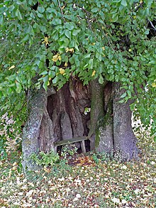
- Kolbenhoflinde
⊙ The"millennial" linden treeat theKolbenhof. Thenatural monumentstands exposed on the street of the hamlet
- Old linden tree at the Kolbenhof
⊙ This equally remarkable tree stands in the courtyard behind a farm building near the transformer station.
Regular events
- Mühlbuck Festival (July)
- Ox Festival (August)
- Parish fair (September)
traffic
The national road 2225 leads to the low stream or after Thalmaessing, the State Street St 2389 to Aberzhausen . Communal roads run to Rabenreuth and Stetten to the RH 40 district road .
Others
- Alfershausen has its own water supply. The source is located on the slope of the southern Franconian Jura above the village of Ohlangen . The elevated reservoir as a water reserve is located above the village of Rabenreuth . The two properties of the Kolbenhof are supplied with fresh water by the "Zweckverband zur Wasserversorgungs der Laibstadt-Schloßberg-Gruppe" from the Heideck municipality. The Kolbenhof provides a board of directors for the Zweckverband.
- The Alfershausen Trade Show took place for the first time in 2010. The local companies presented themselves to the public.
Personalities
- Jürgen Diestelmann (1928–2014), Evangelical Lutheran theologian, pastor in Alfershausen from 1968 to 1975.
- Tobias Nißler (1853–1907), farmer, mayor of Alfershausen, member of the German Reichstag from 1898 to 1907
literature
- Johann Kaspar Bundschuh : Alvershausen . In: Geographical Statistical-Topographical Lexicon of Franconia . tape 1 : A-egg . Verlag der Stettinische Buchhandlung, Ulm 1799, DNB 790364298 , OCLC 833753073 , Sp. 63 ( digitized version ).
- Gottfried Stieber: Alfershaußen . In: Historical and topographical news from the Principality of Brandenburg-Onolzbach . Johann Jacob Enderes, Schwabach 1761, p. 185 ( digitized version ).
Web links
- Alfershausen on the Thalmässing website
- Outline of the history of Alfershausen on personenschiffahrt.de
Individual evidence
- ↑ Thalmässing
- ↑ a b c Federal Statistical Office (ed.): Historical municipality directory for the Federal Republic of Germany. Name, border and key number changes in municipalities, counties and administrative districts from May 27, 1970 to December 31, 1982 . W. Kohlhammer GmbH, Stuttgart / Mainz 1983, ISBN 3-17-003263-1 , p. 733 .
- ↑ http://www.ulischubert.de/geografie/gem1900/gem1900.htm?mittelfranken/hilpoltstein.htm
- ^ Michael Rademacher: German administrative history from the unification of the empire in 1871 to the reunification in 1990. bay_hilpoltstein.html. (Online material for the dissertation, Osnabrück 2006).
- ↑ Bavarian State Office for Statistics and Data Processing (Ed.): Official local directory for Bavaria, territorial status: May 25, 1987 . Issue 450 of the articles on Bavaria's statistics. Munich November 1991, DNB 94240937X , p. 349 ( digitized version ).
- ↑ http://www.thalmaessing.de/de/markt-thalmaessing/gemeindeteile/alfershausen.html ( Memento from April 4, 2014 in the Internet Archive )
- ^ "Linde bei Alfershausen" in the tree register at www.baumkunde.de


