
Aral Sea
| Aral Sea | ||
|---|---|---|

|
||
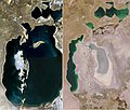
| Drying out of the Aral Sea from 2000 to 2011, outline from 1960 | ||
| Geographical location | Kazakhstan , Uzbekistan | |
| Tributaries | Amu Darya , Syr Darya | |
| Drain | none, because pelvic position | |
| Data | ||
| Coordinates | 44 ° 48 '47 " N , 59 ° 36' 55" E | |
|
||
| Altitude above sea level | 27.5 m | |
| surface | approx. 8300 km² (2015) | |
| volume | approx. 100 km³ | |

The Aral Sea ( Kazakh Арал теңізі Aral teñizi ; Uzbek Orol dengizi ; Russian Аральское море Aralskoje more ; in ancient times Oxiana ) was a large salt lake in Central Asia with no drainage . Due to prolonged drying up, the lake disintegrated into several considerably smaller parts at the turn of the 20th and 21st centuries.
The remains have since formed the Northern Aral Sea , the Western Aral Sea , the Barsakelmessee between the two and the Aralkum Desert . They are all located within the Aralo-Caspian Depression in a basin , the Turan lowlands , and belong to Kazakhstan , Uzbekistan and partly to both countries. Aibugir Sea , located a little further south in Turkmenistan and originally connected to the Aral Sea , was cut off earlier. Because of the continental climate , semi-desert and desert climates prevail.
The drying up of the lake, which has been increasing since around 1960, represents one of the largest human-made environmental disasters in the world. Originally around 68,000 square kilometers (almost the area of Bavaria ), the Aral Sea used to be the fourth largest inland lake on earth .
Prehistory and location

Due to natural climate fluctuations and tectonic movements, the level of the Aral Sea was subject to large fluctuations several times. During the Oligocene , the climate was significantly more humid. A huge inland sea stretched over most of the Aralo-Caspian lowlands . The Sarmatian Sea - part of the Paratethys - was connected to the Black Sea via the Caspian Sea . A connection of the Parathetis to the Mediterranean and thus to the Atlantic no longer existed after the Alpidic orogeny , since, according to common doctrine, the current connection between the Black Sea and the Mediterranean did not come about until a later date.
After the Sarmatian layers had been deposited in the Upper Miocene, the Ustyurt plateau fell dry. The Aral Depression was created by tectonic movements three to five million years ago in the Pliocene Age . They raised and lowered the region around the Aral Sea. These changed the course of the rivers, mainly the Amu Darya and its tributaries, to which the Usboi belonged. An inland sea was formed in the Aralo-Caspian Depression into which the Ustyurt plateau protruded as a peninsula. Natural channels were formed between the Caspian and Aral parts, the latter divided into the Sarykamysch depression and the depression of today's Aral Sea.
The decrease in precipitation in the Holocene (post-ice age) and the resulting relatively increased evaporation and deposition of sediments led to a drop in the water level. The connections to the Caspian and Black Seas were finally interrupted and the large contiguous body of water was divided into individual lakes. What is certain is that the great waters from the Mediterranean to the Aral Sea represent the remains of the primeval ocean Tethys .
Significant water level fluctuations have also been documented for the Holocene: In the Bronze and Iron Ages (from 3000 to 500 BC) the water level of the lake was so low that people settled 42 to 46 meters above sea level . Settlements from late antiquity and the early Middle Ages were found around 10 meters higher. Geological observations of sediment profiles indicate that the lake level was around 3000 and 1000 BC. At 65 and 73 meters respectively, it was located significantly higher than today and the Oxus Delta flooded. It is assumed that the Amu Darya , the previously into over the now dried Usboi Caspian Sea was drained, was diverted by tectonic movements in the Aral Sea, so that the Aral basin was completely filled and the entire lake on the Sarykamysch sink again reached the Usboi. From the 13th century to the middle of the 16th century, the Amu Darya probably flowed again into the Caspian Sea. Around the year 1200 the lake must have almost dried up; a settlement from the 13th century ( Kerderi ) was only 32 meters above sea level .
Recent research to the present
.jpg)
Until the 17th century, the Amu Darya shifted its river bed so far to the east that it no longer reached the Sarykamysch Depression and flowed again into the Aral Sea. From 1695 Semjon Remesow researched in Moscow on the basis of existing sources for the first Siberian Atlas (until 1701) and thus also brought the Aral Sea to the public's attention, although the extent of the lake remained essentially schematic, i.e. H. without bays and most of the islands. It was not until 1850 that the Russian Navy brought out the first more precise map, for which the Russian Admiral Alexei Butakov undertook a research trip. The Berlin magazine for general geography reported on it in German in 1858 and 1866.
Since the beginning of concrete measurements, the water level changed by about 4.40 meters until the Soviet interventions in the water balance:
| year | 1780 | 1824 | 1843 | 1857 | 1862 | 1880 | 1912 | 1920 | 1925 | 1930 | 1935 | 1948 | 1960 |
|---|---|---|---|---|---|---|---|---|---|---|---|---|---|
| Water level above sea level | 51.84 | 49.10 | 51.10 | 49.90 | 50.15 | 49.35 | 53.35 | 52.50 | 53.18 | 52.76 | 53.25 | 52.56 | 53.50 |
climate
The Turan region has a semi-arid climate. It is part of the Eurasian steppe , whereby the vegetation is that of a dry steppe. This is favored by the high mountains in the southwest, south and east, which for example hold off the monsoons of the Indian Ocean coming from the south . In contrast, moisture comes from North Atlantic and European North Sea cloud masses in summer. The dominant winds come from the west and north-west to north-east. Local low pressure areas cause a large number of cyclones. Every year between 30 and 200 millimeters of precipitation falls, at the lake around 100 millimeters. The distribution of precipitation is very irregular. There can be months of drought, but also snowfall. It is possible that before 1960 the Aral Sea increased the humidity near the ground by between 3 and 5 percent and increased the annual local precipitation by 10 mm.
Siltation


The main tributaries are traditionally the Amu Darya (coming from the south) and Syr Darya (from the east) rivers . Since the Stalin era (1929–1953), large amounts of water have been taken from them for the artificial irrigation of huge cotton crops in Kazakhstan and Uzbekistan. Since then, the water level of the lake has continuously decreased due to the lower inflow.
From the 1960s to 1997, the water level fell by 18 meters from 53 meters to 35 meters and the area of the lake decreased by 44.3 percent to 29,630 square kilometers. The water volume was reduced by 90 percent, while the salt content quadrupled. Taissia Budnikowa, who worked for the International Fund for the Rescue of the Aral Sea (IFAS) and in Almaty and has been investigating the Aral Sea since 1977, is convinced that until the end of the 1970s no one could have predicted that the Aral Sea would dry up, that it was common Assumed level fluctuations and the certainty that the missing water from the water-rich north of the Soviet Union could receive the Aral Sea (see # Dawydow plan ). It was only afterwards, when the coastline in the flatter regions had already retreated several kilometers in a year, that "all the major research institutes from Kazakhstan, Uzbekistan, Moscow and Leningrad" knew that the drying out was a realistic scenario. Agadschan Babajew ( Russian Агаджан Гельдиевич Бабаев ), President of the Academy of Turkmenistan and former director of the Desert Institute, was quoted by Spiegel in 1984, before the Davydov Plan was abandoned, with the words: "The future of the Aral Sea has been determined" - and Der Spiegel added: A human-made ecological disaster. Until the political opening of the two former Soviet republics, only scientists, high officials and the residents knew about the ecological problems of the lake.
At that time, the Aral Sea was divided into two main parts by silting up : the southern Great Aral Sea and the northern Small Aral Sea . In 1990 the Great Aral Sea had an area of around 33,000 square kilometers, the Small Aral Sea an area of around 3,000 square kilometers. The Aibugirsee formerly represented a part of the Aral Sea that stretched south-west of the Great Aral Sea well over 100 km to the south, but which had separated before 1960.
Between November 2001 and June 2002 the Wosroschdenij island became a peninsula . In the 19th century it was the third largest, and by 1960 the second largest island in the Aral Sea. Barsakelmes island was the second largest before 1960 and silted up around 1995/96. The island of Kokaral in the north, the largest island before 1960, silted up in the western part of the late 1960s and in the east towards the end of 1989, which led to the division into the Small Aral Sea and the Large Aral Sea . The cities of Aral (Russian: Aralsk) on the north bank and Mujnak on the south bank, which were still on the bank in 1960, are now 30 and around 80 kilometers away from the bank line, respectively, due to siltation, and other former port cities, bathing and bank resorts are now in the middle of the desert , sometimes more than 100 kilometers from today's shore.
The current size of the Aral Sea depends on the weather and the amount of precipitation. Therefore, the measurements taken at different points in time vary considerably with regard to its area and depth. As a result, the information in this regard in many sources deviates significantly from one another.
The water level in the Great Aral Sea fell faster than predicted in the summer of 2003. The surface was only 30.5 meters above sea level . It was 3.5 meters lower than had been forecast in the early 1990s . In the deepest areas of the Great Aral Sea , the water in the lower layers is salty and heavier than that on the surface, and there is no mixing. Only the near-surface water of the Great Aral Sea is heated up in summer and therefore evaporates faster than expected.
Because of the continuous influx of the Amu Darya and the rainfall of around 100 millimeters per year in this region, it was assumed that the Aral Sea cannot dry out completely. In the spring of 2009, the eastern basin was almost completely dry, for the first time since the Middle Ages in the summer of 2016. The resulting desert is called Aralkum .
| year | 1950 | 1960 | 1970 | 1980 | 1990 | 2000 | 2001 | 2002 | 2003 | 2004 | 2005 | 2006 | 2007 | 2008 | 2009 | 8/2010 | 7/2011 | 8/2012 | 8/2013 | 9/2014 | 8/2015 |
|---|---|---|---|---|---|---|---|---|---|---|---|---|---|---|---|---|---|---|---|---|---|
| Water level above sea level | 52.90 | 53.50 | 51.44 | 45.76 | 39.08 | 33.80 | 32.40 | 32.00 | 31.50 | 31.09 | 30.70 | 30.40 | 29.51 | 28.31 | 27.53 | mainly seasonal fluctuations | |||||
| Water volume (km³) | 1058.0 | 1093.0 | 971.7 | 648.7 | 354.0 | 330.0 | 131.2 | 110.8 | 97.2 | 93.5 | 89.8 | 81.4 | 75 | ? | ~ 105 (increase due to damming of the northern Aral Sea ) | ||||||
| Surface (km²) | 65,607 | 68,478 | 60,692 | 51,743 | 35,349 | 36,900 | 21,000 | 18,700 | 17,300 | 16,400 | 15,770 | 13,470 | 14,183 | 10,579 | 8,157 | 13,836 | 10,621 | 8,958 | 9,155 | 7,297 | 8,303 |
| Salinity (g / L) | 10.2 | 9.9 | 11.2 | 16.8 | 30.0 | ~ 20-150; strongly dependent on area and water level ( details ) | |||||||||||||||
Salinization and pollution
Due to the diversion of large amounts of water, hardly any water now reaches the southern part in particular. Alone of the Amu Darya branching Karakum out a substantial part from the water that flowed at earlier times from the south into the Aral Sea. Even the Syrdarya, which used to be arid, hardly brings any water to the Aral Sea, but today it supplies even more water than the Amu Darya, which was often completely dried out by the neighboring states.
While the rivers in the 1950s, with an average of over 60 km³ / year compared to precipitation of a good 9 km³ / year, still contributed a far larger share to the water balance of the Aral Sea, their share fell to 16 km³ / year in the last decade of the 20th century, so that the necessary compensation for the annual evaporation of almost 70 km³ / year to maintain the water level could no longer be achieved. As a result, the lake lacks an annual water volume of over 40 km³, this corresponds to a water flow of 1300 m³ / s, roughly the runoff of the Rhine near Speyer .
The heavy agricultural use and the accelerating silting up of the drainless salt lake have led to increasing salinization of the lake, the bank regions and the surrounding areas in the last 30 years .
In the dry areas around the lake there are dunes in many places, which are a collection of salts blown by the wind. The Kyzylkum desert, which used to begin east of the lake, now extends as far as the lake, while the very salty dunes sometimes extend into the lake. The desert is also increasingly expanding into the fertile agricultural areas south of the lake.
Simultaneously with the dehydration, the salinity of the water also increased, which led to fish deaths with the decline of fishing. The original salt content of the lake was around nine grams per liter (0.9 percent = 9 ‰; 1960). By 1980 it had already increased to 16.5 grams per liter and by the mid-1990s to 30 grams per liter. In 2003, in the Great Aral Sea in the western basin, an average salinity of more than 75 grams per liter was measured in the eastern basin over 150 grams per liter and was therefore a good two or four times as salty as that of the oceans.
After the waterline has withdrawn, a salt and dust desert remains , which is also very dangerous to health due to decades of high levels of artificial fertilizers , herbicides , pesticides and other pollutants.
In the dust in the region around the Aral Sea, the chemically very stable and highly toxic compound TCDD , a by-product of improperly manufactured herbicides , which were used in agriculture on the rivers feeding the Aral Sea, can still be found today . With excessive use of these contaminated herbicides, the plantations irrigated by the diversion of the rivers were defoliated before the mechanical cotton harvest .
The salt and dust pollution is exacerbated by the fact that the Aral Sea lies in a large air corridor from west to south. The air flow also absorbs aerosols and distributes them into the higher layers of the stratosphere , a process that increases global air pollution by around 5 percent. For this reason, pesticides from the Aral region can even be detected in the blood of penguins from Antarctica. Aral dust can also be found on Greenland's glaciers, in Norway's forests and in the Mongolian desert.
Since the 1970s, the number of gastrointestinal diseases and that of the respiratory organs has skyrocketed. So spread typhoid , paratyphoid , hepatitis and tuberculosis from. Typhoid diseases increased in some cases by 20 to 30 times. Organic diseases are also occurring more frequently and the number of cancers increased extremely. Children and pregnant women are worst affected. The infant mortality rate is four times higher than in Russia and in most regions dies every tenth to twelfth child before the age of 1. It is favored by contaminated food and the absorption of high levels of pesticides in breast milk. This makes infant mortality comparable to poor African countries such as Cameroon , Kenya , Sudan or Zimbabwe . This goes hand in hand with a growing number of malformations and disabilities in newborns such as cleft lip and palate or anencephaly (congenital lack of the brain). 30 percent of child mortality can be traced back to acute intestinal diseases. Seventy percent of mothers and 96 percent of women of childbearing potential suffer from anemia due to malnutrition . Salt dust leads to respiratory and eye diseases for many.
Rodents from the drying swamp regions fled to the inhabited areas and transmitted pathogens when they were in wells and soil. These include plague , cholera, and tularemia . In 1989 at least six out of ten people had a clinical picture, whether they were children or adults. It is estimated that around 25 percent of the population in the cotton growing areas are mentally retarded . It is assumed that the health consequences of the drying up of the Aral Sea are similar in extent to the consequences of the reactor accident in Chernobyl , but the attention paid to the Aral Sea in the western world is very low.
According to Taissia Budnikova, awareness of the catastrophic situation was made more difficult not only by the politically motivated secrecy of the Soviet republics, but also by the mentality of the Kazakh people. The Kazakh people have always lived in their history under "difficult natural, ecological and climatic conditions" and are used to difficult living conditions, so that people do not see the situation at the Aral Sea as "as dramatic as it was perceived on an international level".
In summary, the reasons for the high mortality and morbidity are:
- Bad health care and health care
- Bad social living conditions
- Severe salinity and chemical and bacteriological pollution of the drinking water
- Inhaling salt and dust from the air
- Contamination of food by pesticides and fertilizers in the soil
- Inheritance of diseases and genetic defects
Southwest of the Aral Sea has in Sarykamysch Valley now from diverted waters of the Amu Darya and agricultural effluents Sarygamysh Lake formed. The water of this lake is considered to be poisonous because of its high content of pesticides and heavy metals .
The number of species and individuals in the Aral Sea is decreasing. The same can also be seen on the banks. After the regression of the lake, small invertebrates, lizards, snakes and rodents settle on the shoreline, but these disappear quickly as the sand of the Kyzylkum eventually turns these areas into hostile salt steppes.
Davydov Plan

Projects to divert Siberian rivers came into being in the 19th century. The abundance of water in northern Siberia was then assessed as superfluous; In connection with the planning of large canals such as the Suez or Panama Canal, consideration was also given to the realization of a year-round development of Siberia by water in the form of a canal.
Following the geographic lowlands, part of the water of the great West Siberian rivers, in particular the Ob and its tributary Irtysh , should pass through a canal along the Turga Depression and through the dry, drainless basins of the Turan lowlands, taking advantage of the Tobol , Ubagan and Turgai courses be diverted over the Schalkartengis and the Aral Sea through the dried up river bed of the Usboi into the Caspian Sea.
Considerations in this regard were concretely conceived in the Soviet era in view of the incipient drying up of the Aral Sea ( Davydov Plan ), but it was not implemented for cost reasons and because of unforeseeable ecological effects. Similar plans are still being picked up to this day, most recently by Kazakh President Nursultan Nazarbayev in 2010.
Saving the Northern Aral Sea


In order to save at least the smaller (northern) part of the Aral Sea, a dike was built by Kazakhstan in the 1990s to hold back the water. During its existence, the water level in the Little Aral Sea increased , the climate improved and more fish could be caught again. However, due to the inadequate construction, this dam broke after a short time. As a result, the construction of a new dam began in 2003. Since the World Bank also provided funds for this, this time concrete could be used as a building material. The new dam is also called Kokaral Dam . In addition to this dam construction, measures have also been taken to improve the irrigation system of the Syr-Darja , which flows into the northern part of the lake. Sewers were repaired and in some cases also concreted out. This should lead additional water into the lake. In 2005 the Kokaral Dam was completed.
By 2006 the lake level rose by 3 meters, the area increased by 900 km² and the volume by 11 km³, the salinity sank significantly. Since the Small Aral Sea has a drain, the concentration of toxins also decreased: They were washed into the Great Aral Sea . As a result, the fishing yields increased and the dust pollution sank significantly - at least when there is no south wind blowing, which brings dust from the Great Aral Sea . In some places, the coastline has shifted more than 75 kilometers. The Kazakh government hopes that the Little Aral Sea will largely recover through further improvements to the irrigation system.
The waterline in the northern part of the lake has - after a low in 2004 at 32 m above sea level. M. - stabilized again in 2009 at a height of 43 meters. The water area of the northern part has grown by more than 30 percent, to around 3300 square kilometers, the volume is 27 km³. The salt content there is now again below 1.5 percent, compared to four percent at the end of the 1990s ; the fish stocks have recovered.
The disadvantage of the project is that the drying up of the southern part is accelerated: the water that fills the northern part of the lake is missing in the south. As a result of the dam project, the water flow in the southern half was reduced by around a third. As a result, Uzbekistan, which owns the southern half of the Great Aral Sea , attacks the project as “selfishness”. The Kazakh government countered that "there is no hope of saving the entire lake if Uzbekistan does not do without irrigation along the Amu-Darya, which is why they made the best of the situation".
Flora and fauna
There are reports from 1852 that tell of the abundance of carp , catfish , sturgeon , pelicans , gulls , hedgehogs , goats , antelopes , wolves and tigers in and around the lake. The lake was weakly brackish at that time (salinity a little over 1 ‰).
use
The island of rebirth , which was formerly located in the lake, served the Soviet military and the Soviet authority Biopreparat from 1936 to 1991 as a test site for biological weapons. Among other things, the causative agents of anthrax ( Bacillus anthracis ) , plague ( Yersinia pestis ) and tularemia ( Francisella tularensis ) were tested. The military in Uzbekistan and NATO fear that terrorists could obtain material for biological weapons here. This risk was increased when the former island joined the south coast in 2002 and thus became a peninsula.
Music video

The 2014 music video for the title Louder than Words from the music album The Endless River by the British rock band Pink Floyd shows pictures of the Aral Sea. Large parts of the video were shot by the director Aubrey Powell on the almost dry Aral Sea between Kazakhstan and Uzbekistan. Powell contrasts the seemingly surreal landscapes with the hopelessness of a family whose grandfather still owned his own ship , which is now lying as a decaying wreck on the salty seabed.
Historical pictures

Painting by Taras Shevchenko from 1848. Schooner on the Aral Sea.

Ships of the Imperial Russian Navy of the Aral Fleet 1850.

The 1853 map of the Aral Sea published for the Journal of the Royal Geographical Society in London.
The Aral Sea in 1989 and 2008
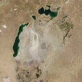
The shrinking of the Aral Sea in satellite images from 2000 to 2018


literature
- Historical documents on the development of the Aral Sea from 1965 to 1990 were collected as the “Aral Sea Archival Fund”. In 2011, these were included in the list of World Document Heritage by UNESCO at the request of the Government of Kazakhstan .
- Ernst Giese, Gundula Bahro, Dirk Betke: Environmental destruction in arid regions of Central Asia (West and East Turkestan). Causes, effects, measures . Franz Steiner Verlag, Stuttgart 1998.
- René Létolle, Monique Mainguet: The Aral Sea. An ecological disaster . Springer Verlag, Berlin, Heidelberg 1996.
- J. Sehring: Aral Sea. In: Steinbach, U .; Von Gumppenberg, M.-C .: Central Asia. History - Politics - Economy. Munich 2004, pp. 21–26.
- Philippe Sorrel: The Aral Sea. A palaeoclimate archive . Dissertation, University of Potsdam / Université Claude Bernard - Lyon 1, 2006. ( full text )
- Äbdischämil Nurpeissow : The dying lake , Roman, Berlin 2006.
- Igor S. Zonn, Michael H. Glantz, Andrey G. Kostianoy, Aleksey N. Kosarev: The Aral Sea Encyclopedia . Springer Verlag, Berlin, Heidelberg 2009
Movies and radio
- Early Warning - Late Insight. Documentation with contemporary history and documents from 2007. SWR / WDR, 2007 ( online at YouTube )
- Waiting for the Sea (2012 feature film)
- Planet Sand: Aralkum - The youngest desert in the world. By Pierre-François Gaudry , German premiere May 1, 2017 on Arte ( online on YouTube )
- The miracle of the Little Aral Sea: Documentation Germany 2012 on ard.de, accessed September 25, 2013
- The miracle at the Little Aral Sea: The return of water, fish and people ( Memento from June 15, 2013 in the Internet Archive ) Feature by Rita Knobel-Ulrich on ndr.de,
- The man-made eco-disaster at the Aral Sea was sometimes considered the world's most serious environmental disaster podcast on srf.ch, accessed September 25, 2013
- Through the daring heart of Central Asia: Episode 2 Aral Sea ( Memento from September 29, 2013 in the Internet Archive ) Thomas Junker on mdr.de, accessed September 25, 2013
Web links
- Dimitri Ladischensky : Elender Staub ( Memento from December 23, 2016 in the Internet Archive ) In: mare , August 2004 edition
- Detailed article in the Eurasian magazine ( Memento from December 20, 2016 in the Internet Archive ) with further information on earlier modern history
- Aral Sea: News from an ecological catastrophe scientific dossier in scinexx
- Destabilization and conflict potential of forecast environmental changes in the Central Asia region by 2020/2050. ( Memento from September 7, 2016 in the Internet Archive ) (PDF file; 1.65 MB)
- Luke Dörrie: Dry Placed In: The daily newspaper (taz) , December 2, 2017: "The Aral Sea threatened to disappear now working organizations against the circumstances: The World Agroforestry Center (ICRAF) in Kyrgyz Bishkek takes it with the water-consuming agriculture. The help is welcome "
Individual evidence
- ^ Aral Sea in Brockhaus' Kleines Konversations-Lexikon, fifth edition, volume 1. Leipzig 1911., p. 219. (online at zeno.org)
- ↑ UNEP / DEWA / GRID: The geological evolution of the Black Sea, http://www.grid.unep.ch/bsein/publish/geoevol1.htm
- ^ A b Arved Schultz: The natural landscapes of Russian Turkestan: Basics of regional studies. Walter de Gruyter, 2016. ISBN 3111588912 , ISBN 9783111588919 . ( P. 17/18 online at Google Books )
- ↑ Archaeological finds provide information about earlier water levels: The mirror of the Aral Sea over time . In: Neue Zürcher Zeitung . November 22, 2006, ISSN 0376-6829 ( nzz.ch [accessed March 7, 2017]).
- ^ Ryszard Kapuściński, Martin Pollack (translator): Empire: Soviet forays. AB - The Other Library. Berlin, 2015. ISBN 978-3-8477-2008-9 , ISBN 3-8477-2008-2
- ↑ Gondwana Research 2014 Krivonogov et al. (PDF (in web archive)) Accessed March 7, 2017 (English).
- ↑ Чертёжная книга Сибири (Book of Siberia) in the academic.ru dictionary
- ↑ a b c d The many faces of the Aral Sea. novastan.org, in the original by Lena Khassanova: МОРЕ МОЁ: КАК И ЧЕМ ЖИВЕТ АРАЛ (My Sea: How and what does the Aral Sea do?), published on Living Asia, November 2, 2016
- ^ Butakow in Meyers Konversationslexikon. Publishing house of the Bibliographisches Institut, Leipzig and Vienna, fourth edition, 1885–1892
- ^ The Aral Sea level fluctuation for 1780-1960. Retrieved February 28, 2017 .
- ↑ a b Ernst Giese, Gundula Bahro, Dirk Betke (1998): Environmental destruction in arid regions of Central Asia (West and East Turkestan). Causes, effects, measures. P. 59.
- ↑ a b When Siberia's rivers flow backwards. Spiegel online archive, from print edition 47/1984, November 19, 1984
- ↑ Satellite image of the week: Eastern basin of the Aral Sea dry for the first time since the Middle Ages (SPIEGEL online from September 27, 2014).
- ↑ Aral Sea: Eastern basin is now desert .
- ↑ Sigmar-W. Breckle: Combating desertification and rehabilitation of the salt deserts in the region at the Aral Sea ( Memento of March 17, 2008 in the Internet Archive ).
- ↑ Sigmar-W. Breckle: The vanished Aral Sea - Combating desertification through phytomelioration ( Memento of the original from May 6, 2009 in the Internet Archive ) Info: The archive link was automatically inserted and not yet checked. Please check the original and archive link according to the instructions and then remove this notice. .
- ↑ a b c d Bathymetric characteristics of the Aral Sea. Retrieved February 28, 2017 .
- ↑ fba (2006): Aral Sea dying of thirst .
- ↑ http://www.ntsomz.ru/projects/eco/econews_271108_beta
- ↑ a b Mirabdullayev I. M, Mustfaeva Z. A, & BA Tashmukhamedov (2003): Succession of the ecosystems of the Aral sea during its transition from oligohaline to polyhaline waterbody. 35th International Workshop on Ocean Dynamics — Dying and Dead Seas. Liège, Belgium.
- ↑ a b In: Aladin, N.V. et al. (2005): Modern hydro-biological state of the Small Aral sea. In: Envirometrics 2005, No. 16, pp. 375-392. (PDF file; 333 kB)
- ^ M. Groll (Philipps-Universität, Marburg, Germany) R. Kulmatov (National University of Uzbekistan, Tashkent, Uzbekistan) N. Mullabaev (National University of Uzbekistan, Tashkent, Uzbekistan) A. Belikov (National University of Uzbekistan, Tashkent, Uzbekistan) Ch. Opp (Philipps-Universität, Marburg, Germany) D. Kulmatova (National University of Uzbekistan, Tashkent, Uzbekistan): Rise and Decline of the fishery industry in the Aydarkul-Arnasay lake system (Uzbekistan) - effects of reservoir management , irrigation farming and climate change on an unstable ecosystem. (PDF) In: CDZ Symposium on Lake-catchment interactions and their responses to hydrological extremes, Nanjing. Phillips University of Marburg, October 10, 2015, accessed on February 28, 2017 .
- ^ Frederic Golden: Environment: Making Rivers Run Backward . In: Time . June 14, 1982, ISSN 0040-781X ( time.com [accessed March 7, 2017]).
- ^ SPIEGEL ONLINE, Hamburg, Germany: PROJEKT DAWIDOW: To die - Der Spiegel 19/1950. Retrieved March 7, 2017 .
- ^ Soviet Union: Dangerous and too expensive . In: The time . March 21, 1986, ISSN 0044-2070 ( zeit.de [accessed March 7, 2017]).
- ↑ Питьевая вода и поворот рек. Retrieved March 7, 2017 .
- ↑ В Ташкенте представили проект суперканала: от Карского моря до Персидского залива. Retrieved March 7, 2017 .
- ↑ Nature: Northern Aral Sea recovering. Kazakhstan plans second phase of project. Report of April 12, 2007 ( doi: 10.1038 / news070409-8 ).
- ↑ Return of the Aral Sea: The desert gives way to photo series in Spiegel online from June 4, 2017
- ↑ Dried up and quilted: The Aral Sea from 1960 to 2008 Today, thanks to a dam, the Little Aral gets fresh water again . In: Neue Zürcher Zeitung . ( nzz.ch [accessed on March 8, 2017]).
- ↑ Louder Than Words. Franz Hendricks, October 11, 2014, accessed November 7, 2014 .
- ↑ Aral Sea Archival Fund | United Nations Educational, Scientific and Cultural Organization. Retrieved March 28, 2017 (English).