
Arouca (Portugal)
| Arouca | ||||||
|---|---|---|---|---|---|---|
|
||||||
| Basic data | ||||||
| Region : | Norte | |||||
| Sub-region : | Porto metropolitan area | |||||
| District : | Aveiro | |||||
| Concelho : | Arouca | |||||
| Coordinates : | 40 ° 56 ′ N , 8 ° 15 ′ W | |||||
| Residents: | 3195 (as of June 30, 2011) | |||||
| Surface: | 8.49 km² (as of January 1, 2010) | |||||
| Population density : | 376 inhabitants per km² | |||||
| politics | ||||||
| Address of the municipal administration: | Junta de Freguesia de Arouca Rua Dr. Figueiredo Sobrinho, 11A 4540-133 Arouca |
|||||
| Website: | arouca.aroucanet.com | |||||
| Arouca district | ||||||
|
||||||
| Residents: | 22,359 (as of June 30, 2011) | |||||
| Surface: | 329.12 km² (as of January 1, 2010) | |||||
| Population density : | 68 inhabitants per km² | |||||
| Number of municipalities : | 16 | |||||
| administration | ||||||
| Administration address: | Câmara Municipal de Arouca Praça do Município 4544-001 |
|||||
| President of the Câmara Municipal: | José Artur Tavares Neves ( PS ) | |||||
| Website: | www.cm-arouca.pt | |||||


Arouca is a vila (small town) and a district ( concelho ) in Portugal with 3195 inhabitants (as of June 30, 2011). Arouca belongs to the metropolitan region of Porto ( Portuguese : Área Metropolitana do Porto , short: AMP ), the metropolitan region in northern Portugal.

In the historic center of Arouca
In the Mosteiro de Arouca monastery

The Frecha da Mizarela waterfall

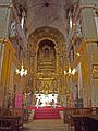
In the Mosteiro de Arouca monastery


history
The area was already settled before the arrival of the Romans , but no finds of major importance were made. Even during the Roman occupation, the area remained inhabited, but insignificant, as the few finds show. The following Germanic tribes, especially the Suebi , only left an etymological legacy in various place names in the district, such as Sá, Saril, Alvarenga, Burgo, Escariz, Friães or Melareses. The records of the Moors from Arouca indicate that almost all Christians had fled the area to more remote, more protected places.
Arouca only gained importance with the construction of the monastery in the 10th century. The place received its first town charter ( Foral ) in 1151 from Portugal's first king, D. Afonso Henriques . With the arrival of Mafalda, daughter of the second Portuguese king Sancho I (1154-1211), between 1217 and 1220 , the women's monastery flourished and with it the place. Even after Mafalda's death in 1256 , the monastery remained prosperous thanks to her legacies. Mafalda was beatified in 1792 and her remains were transferred to the Arouca monastery in 1793 .
King Manuel I had renewed the town charter in 1513. The district of Arouca continued to grow in size through incorporations, in particular through the numerous incorporations in the course of the administrative reforms after the Liberal Revolution in 1822 .
Sights, sports and culture
Among its numerous architectural monuments are, in addition to some historical public buildings, above all sacred buildings , including the Mosteiro de Arouca monastery, built in the 10th century, and the parish church Igreja Paroquial de Arouca (also Igreja de São Bartolomeu ). In the monastery, the museum is Museu de Arte Sacra de Arouca housed in the sacred art is shown of books, paintings and sculptures to ceramics and jewelry.
The Estádio Municipal de Arouca is a football stadium and part of a sports field in Vale da Vila de Arouca. It was inaugurated in 2006 and has a capacity of 2500 spectators. It is used by the local FC Arouca to host its home games in the Segunda League .
Numerous rivers run through the district, on which some river baths ( Portuguese : praia fluvial ) are created. The Frecha da Mizarela waterfall is also located here. In the Geoparque Arouca , which stretches across the entire district, there are 13 signposted hiking trails and nature trails that lead past very large trilobites and other fossils and stone formations.
The international short film festival aroucafilmfestival has been held here every year since 2003 .
administration
circle
 Arouca is the seat of a district of the same name. The neighboring areas are (starting clockwise in the north): Castelo de Paiva , Cinfães , Castro Daire , São Pedro do Sul , Vale de Cambra , Oliveira de Azeméis , Santa Maria da Feira and Gondomar .
With the regional reform in September 2013 , several municipalities were merged to form new municipalities, so that the number of municipalities decreased from 20 to 16.
The following municipalities ( freguesias ) are in the Arouca district:

| local community | Population (2011) |
Area km² |
Density of population / km² |
LAU code |
|---|---|---|---|---|
| Alvarenga | 1,223 | 38.77 | 32 | 010402 |
| Arouca e Burgo | 5,178 | 15.24 | 340 | 010421 |
| Cabreiros e Albergaria da Serra | 231 | 31.23 | 7th | 010422 |
| Canelas e Espiunca | 1,183 | 35.73 | 33 | 010423 |
| Covelo de Paivó e Janarde | 222 | 44.38 | 5 | 010424 |
| Chave | 1,253 | 10.91 | 115 | 010407 |
| Escariz | 2,222 | 17.98 | 124 | 010409 |
| Fermedo | 1,340 | 11.11 | 121 | 010411 |
| Mansores | 1,081 | 14.08 | 77 | 010413 |
| Moldes | 1,257 | 28.01 | 45 | 010414 |
| Rossas | 1,599 | 11.11 | 144 | 010415 |
| Santa Eulália | 2,253 | 23.05 | 98 | 010416 |
| Sao Miguel do Mato | 598 | 17.10 | 35 | 010417 |
| Tropeço | 1,150 | 17.84 | 64 | 010418 |
| Urrô | 1,029 | 10.79 | 95 | 010419 |
| Várzea | 540 | 1.79 | 302 | 010420 |
| Arouca district | 22,359 | 329.12 | 68 | 0104 |
Population development
| Population in Arouca County (1801–2011) | |||||||||
|---|---|---|---|---|---|---|---|---|---|
| 1801 | 1849 | 1900 | 1930 | 1960 | 1981 | 1991 | 2001 | 2011 | |
| 7,072 | 11,111 | 16,671 | 21,433 | 26,378 | 23,896 | 23,894 | 24,227 | 22,359 | |
Town twinning
Web links
Individual evidence
- ↑ www.ine.pt - indicator resident population by place of residence and sex; Decennial in the database of the Instituto Nacional de Estatística
- ↑ a b Overview of code assignments from Freguesias on epp.eurostat.ec.europa.eu
- ↑ www.ine.pt - indicator resident population by place of residence and sex; Decennial in the database of the Instituto Nacional de Estatística
- ↑ www.monumentos.pt (under Cronologia ), accessed on January 6, 2012
- ↑ www.cm-arouca.pt , accessed on January 6, 2013
- ↑ www.monumentos.pt , accessed on January 6, 2013
- ^ Publication of the administrative reorganization in the Diário da República gazette of January 28, 2013, accessed on March 16, 2014
- ↑ www.anmp.pt , accessed on January 6, 2013
