Au am Leithaberge
|
market community Au am Leithaberge
|
||
|---|---|---|
| coat of arms | Austria map | |
|
|
||
| Basic data | ||
| Country: | Austria | |
| State : | Lower Austria | |
| Political District : | Bruck an der Leitha | |
| License plate : | BL | |
| Surface: | 16.71 km² | |
| Coordinates : | 47 ° 55 ' N , 16 ° 33' E | |
| Height : | 211 m above sea level A. | |
| Residents : | 948 (January 1, 2020) | |
| Population density : | 57 inhabitants per km² | |
| Postal code : | 2451 | |
| Area code : | 0 21 68 | |
| Community code : | 3 07 01 | |
| NUTS region | AT127 | |
| Address of the municipal administration: |
Hauptplatz 10 2451 Au am Leithaberge |
|
| Website: | ||
| politics | ||
| Mayor : | Herbert Mihaly (Mihaly Future Alliance) | |
|
Municipal Council : ( 2020 ) (15 members) |
||
| Location of Au am Leithaberge in the Bruck an der Leitha district | ||
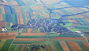
 Aerial view of Au (from the west) |
||
| Source: Municipal data from Statistics Austria | ||
Au am Leithaberge is a market town with 948 inhabitants (as of January 1, 2020) in the Bruck an der Leitha district in Lower Austria ( Austria ).
geography
Geographical location
Au am Leithaberge is located in the Lower Austrian industrial district on the western edge of the Leitha Mountains . The area of the market town covers 16.71 square kilometers. 35.81 percent of the area is forested. The cadastral community bears the name Au am Leithagebirge .
Neighboring communities
| Leithaprodersdorf , Seibersdorf | Hof am Leithaberge | |
| Stotzing |

|
|
| Oslip , riflemen on the mountains | Donnerskirchen |
history
In ancient times the area was part of the province of Pannonia .
Two Celtic burial fields were uncovered on the slope of the Leitha Mountains in 2012 at the latest .
- The cemetery "Kleine Hutweide" lies on a north-western foothill of the mountain range. 28 Latène period burials were excavated between 1926 and 1931, including the grave of a blacksmith with finds of an anvil , iron chisels and a hammer head. A horse snaffle , swords, lance tips and various ceramics were also included in some of the graves.
- In the “Mühlbachäcker” cemetery, a total of 17 grave sites were uncovered from 1933 to 1937 and 1970, which can also be classified as belonging to the La Tène period. As in the “Kleine Hutweide” cemetery , the graves are also surrounded by dry stone walls and the paths between them are partially paved with stone. At some grave sites post-occupancy or multiple occupancy can be determined.
In the course of the construction of a wind farm with 5 wind turbines, archaeologists made finds and traces of Neolithic and Bronze Age settlements. a. a tumulus (approx. 1600 BC). The area in the area of the wind farm has been inhabited continuously since the 6th millennium BC.
Population development
According to the results of the census in 2001 there were 909 inhabitants. In 1991 the market town had 888 inhabitants, in 1981 812 and in 1971 952 inhabitants.
Culture and sights

- Parish church Au am Leithaberge
- The historic noble mill , which was first mentioned in 1375, exists in the area of the village .
Economy and Infrastructure
In 2001 there were 31 non-agricultural workplaces, and according to the 1999 survey there were 39 in agriculture and forestry. According to the 2001 census, the number of people in employment at home was 412. In 2001, the employment rate was 46.2 percent. There were unemployed people in the area on average in 2003 1.
mayor
- –2010 Josef Jandrinitsch (ÖVP)
- since 2010 Herbert Mihaly (ÖVP, since 2015 future alliance Mihaly (ZUM))
Web links
- 30701 - Au am Leithaberge. Community data, Statistics Austria .
Individual evidence
- ^ Susanne Sievers / Otto Helmut Urban / Peter C. Ramsl: Lexicon for Celtic Archeology. A-K and L-Z ; Announcements of the prehistoric commission, publishing house of the Austrian Academy of Sciences, Vienna 2012, ISBN 978-3-7001-6765-5 , p. 90 f.
- ↑ Primeval burial mound discovered near Au rf.at, July 22, 2018, accessed July 22, 2018.


