
Dettenheim (Weissenburg)
|
Dettenheim
Large district town of Weißenburg in Bavaria
|
||
|---|---|---|
.png) |
||
| Height : | 435 m above sea level NN | |
| Residents : | 873 | |
| Incorporation : | July 1, 1972 | |
| Postal code : | 91781 | |
| Area code : | 09142 | |
Location of Dettenheim in Bavaria |
||

Dettenheim is a district of Weißenburg in Bavaria in the central Franconian district of Weißenburg-Gunzenhausen and is located in the Altmühltal Nature Park near the European watershed . The place is the largest district of the city after the main town Weißenburg.
location
The place is about five kilometers south of Weißenburg at the source of the Swabian Rezat . This rises about 900 meters from the town center and flows from Dettenheim in a northerly direction to Weißenburg and on to Georgensgmünd , where it joins the Franconian Rezat to the Rednitz . The place is located in the south of the Weißenburger Bay near the Weißenburger Alb , a mountain range of the Franconian Alb . To the north lies the Weißenburger Stadtwald . Federal highway 2 ran through the center of the town until August 2017 , which , coming from Berlin and Nuremberg , continues to Augsburg and Munich . Dettenheim can be reached on foot on the Frankenweg , a long-distance hiking trail that leads 527 km from the Rennsteig to the Swabian Alb .
history
Prehistory and early history
The settlement of the district Dettenheim goes to the prehistoric time back. In the run-up to the construction of a bypass road west of the village, intensive multi-phase traces of settlement from the Iron Age were uncovered and documented during two excavation campaigns in 2014 and 2015 under the direction of the archaeologist Arne Schmid-Hecklau . Settlement remains and graves from the Latène period were located closer to Dettenheim . The older settlement of the Hallstatt period , which also showed traces of use from the Latène period, comprised a completely flattened barrow field on the prehistoric valley floodplain of the Rezat to which a palisade wall with an upstream moat belonged. When today's primary school was built in Dettenheim, not far from the Latène period settlement discovered in 2014, burial mounds with burials from the Hallstatt period came to light.
During the Roman Empire , as part of the Rhaetian Limes expansion, a military road was laid from the Danube to the Weissenburg Castle , which is now believed to be in the southern area of Dettenheim under Donauwörther Straße. Not far from this route, a villa rustica was built at today's eastern exit of the village , which was lost in the course of the Limes Falls , probably around 259/260 AD at the latest.
middle Ages
In the early Middle Ages , continuous evidence of settlement begins in Dettenheim. During the 6th and 7th centuries there was an Alemannic row burial ground on the old Roman road immediately north of today's main road , which was discovered in 1889 by the Limes researcher Wilhelm Kohl (1848–1898).
In 914 (according to another source even as early as 802) Dettenheim was first mentioned in the Salbuch of the Reichserbmarschalls von Pappenheim as "Tetenheim" (later also "Tetorsheim", home of Tetor / Dietrich). In the years 1057-75 the construction and consecration of the first church took place. In 1214 the village became the property of the Hereditary Marshal von Pappenheim , in 1350 the knight Reinmar von Kreßberg also sold the customs in Dettenheim to the Marshal von Pappenheim. During the Bavarian War between Duke Ludwig the Bearded and Margrave Friedrich von Brandenburg 1420-22, the village was completely burned down.
Early modern age
A similar fate was repeated in the Thirty Years' War , at the end of which two of the original 42 families remained in the village. In the War of the Spanish Succession , French troops looted and ravaged the village in 1704; From the front above the village (the Weißenburg line ), the Sternschanze, a four-beam, star-shaped entrenchment with a rampart, a ditch in front and raised corners, has been preserved as a cannon. The archaeological excavations in November 2014 brought to light a previously unknown, eleven-meter-wide fortification trench of the Bavarian state defense line from the War of Succession south of Dettenheim. This ran in a north-south direction.
A wooden castle built in 1721/22 was later demolished and replaced by a stone building in 1782, which is now privately owned.
Modern times
With the Rhine Confederation Act in 1806, the Grafschaft Pappenheim, to which Dettenheim still belonged, became part of the new Kingdom of Bavaria . The First and Second World Wars meant another deep cut for the development of the village, a total of 42 men did not return from both wars. From 1946 onwards, many expelled Sudeten Germans found their way to Dettenheim, which led to a sudden increase in the population. It was independent until the municipal area reform in 1972, the residents decided in a vote to become part of the large district town of Weißenburg in Bavaria in the future. The incorporation took place on July 1, 1972. Today Dettenheim has about 430 inhabitants.
Bypass and village renewal

Until August 2017, Dettenheim was heavily burdened by the busy Bundesstraße 2 , which divided the town center. According to the city building authority, the effects were and are an outdated town center, vacancies and dilapidated houses, which Dettenheim is doing "as an example of the negative urban development changes," said city architect Thomas Schwarz from the Weißenburg city administration. A bypass had been planned as a solution for decades, and a concept for village renewal had also been developed since 2009. On May 21, 2012, the planning approval decision was issued for a 3.40 km long, three-lane bypass. The building approval was given on July 30, 2014. With this, Federal Transport Minister Alexander Dobrindt had approved the bypass. The tenders could now be started. As of October 2014, the archaeological company Archbau from Augsburg began the first excavations on the gas pipeline laid in advance and the survey of the future route of the bypass road, which is part of the tender. The groundbreaking ceremony for the actual construction work, which was planned until July 2017, took place on December 5, 2014. The bypass was opened to traffic on August 9, 2017.
Place and sights
The west-east facing village street goes back to a medieval brook on both sides of the Swabian Rezat and crosses the old military and trade route Augsburg – Nuremberg. The buildings consist entirely of Jura-style farms . The courtyards are laid out in the shape of a hook, the residential stables, mostly systems from the later 18th and first half of the 19th centuries, face the street without the gable. Most of them are plastered quarry stone buildings whose flat gable roofs are only occasionally covered with limestone slabs. At the intersection with Augsburg-Nürnberger Straße, the Evangelical-Lutheran parish church of St. Nikolaus, dating back to the Middle Ages, rises up, the nave of which, however, was replaced in the second half of the 19th century by a neo-Romanesque new building with restrained interior design, the former courtyard and a large former brewery inn, also in Jura construction. At the southern end is next to the 1782-built former hunting lodge of the Counts of Pappenheim in 1956 at the suggestion of the then parish priest, curate Gregor cutting, in ecumenical collaboration of both denominations Catholic built barn Church St. Gunthildis whose impressive church in a converted timber-framed barn dating 1814 is located.

Small Jura houses in Dettenheim, probably built in the 18th century

Barn church
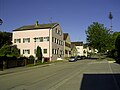
Village street in Dettenheim
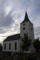
St. Nicholas Church

Dettenheim, castle from the street side

Dettenheim, castle from the garden side


village life
Village life is shaped by the following associations:
- Schützengesellschaft Bavaria Dettenheim
- 1. FC Dettenheim
- Dettenheim volunteer fire department
- Trumpet Choir Dettenheim
- Evangelical rural youth Dettenheim
Personalities
- Adam Vorbeck (* 1873 Aschaffenburg, † 1954 Dettenheim), entrepreneur and politician from Memel Land
- Ludwig Fellner (1917–2006), German landscape painter
- Johann Alexander Döderlein (1675–1745) spent parts of his youth in Dettenheim in the late 17th century.
Others
Approx. Two kilometers west of Dettenheim is the village of Graben where Charlemagne wanted to build the Fossa Carolina named after him in 793 as a connection between the North Sea and the Black Sea . Curiously, there is also a place called Graben at a similar distance from the Baden community of Dettenheim , today part of the community of Graben-Neudorf .
Web links
Individual evidence
- ↑ www.nordbayern.de, Jan Stephan: An important Iron Age settlement discovered in Dettenheim ; accessed on October 13, 2016.
- ^ History of Dettenheim
- ^ Wilhelm Volkert (ed.): Handbook of Bavarian offices, communities and courts 1799–1980 . CH Beck, Munich 1983, ISBN 3-406-09669-7 , p. 592 .
- ↑ see article from July 17, 2014 in Weißenburg Aktuell
- ↑ see the interactive map with the village renewal projects Weißenburg Aktuell from July 16, 2014
- ^ Auerhammer: Dettenheim bypass approved by Federal Transport Minister Dobrindt, Weißenburg Aktuell of July 16, 2014
- ↑ Staatliches Bauamt Ansbach, August 27, 2015: Dettenheim road construction project ; accessed on October 30, 2016.
- ↑ "Finally finished after 34 years" in: Weißenburger Tagblatt of August 10, 2017
- ^ Project website of the State Building Authority Ansbach. Retrieved September 4, 2017 .
- ^ Ensemble Dettenheim
- ^ Description of Dettenheim on the website of the city of Weißenburg
- ↑ Dettenheim fire department
- ↑ Weißenburg donates its own culture prize , published 1986, accessed on June 22, 2016

Dettenheim | Emetzheim | Gänswirthshaus | Haardt | Hagenbuch | Hammer mill | Hattenhof | Houses on the Wülzburger Berg | Heuberg | Holzingen | Kattenhochstatt | Throat | Laubenthal | Markhof | Niederhofen | Oberhochstatt | Potschmühle | Rothenstein | Grinder on the mountain | Narrow meadows | Stadelhof | Suffersheim | Weimersheim | Weißenburg | Weißenhof | Wülzburg