Wülzburg
| Wülzburg | |
|---|---|
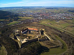
 Aerial view of Wülzburg (2020) in the background Weißenburg |
|
| Data | |
| place | Weißenburg in Bavaria |
| builder | Rochus zu Lynar , Blasius Berwart |
| Client | Georg Friedrich I of Brandenburg-Ansbach-Kulmbach |
| Construction year | 1588 to around 1610 |
| Floor space | 73,000 m² |
| Coordinates | 49 ° 1 ′ 32 ″ N , 11 ° 0 ′ 19 ″ E |
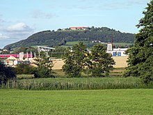
The Wülzburg is a historic fortress that was built between 1588 and around 1610. It is located above the large district town of Weißenburg in Bavaria ( Weißenburg-Gunzenhausen district ) on the Wülzburger Berg , an elevation of the part of the Southern Franconian Alb called the Weißenburger Alb .
The fortress was originally a Benedictine monastery , which was converted into a fortress by the Margraves of Ansbach in 1588 . Today it forms the Wülzburg district of Weißenburg with the residential buildings to the south of it . In addition to the Jülich Citadel (1549 ff.), The Dömitz Fortress (1559 to 1565) and the Spandau Citadel (1560 ff.), The Wülzburg is one of the four closely related Renaissance fortresses that have survived in German-speaking countries. In a one-off sequence, they illustrate the typical Renaissance fortifications .
Geographical location
The Wülzburg is located in the Altmühltal nature park about 2.5 km east-southeast of the city center of the Weißenburg core city . She is at the Weißenburger Alb belonging Wülzburger mountain , which with 620 m above sea level. NHN is the highest mountain top of the southern Franconian Alb after the neighboring Laubbichel to the east-northeast ( 635.7 m ) . The platform of their northeast bastion ( called Roßmühle ) is at a height of 643.8 m .
To the northeast of the Wülzburger Berg, which is partly wooded on its flanks, lies the village of Kehl below the Wülzburg , to the south of Schleifer am Berg , to the west of the Glaserhaus , houses on the Wülzburger Berg and Birkhof, and to the northeast the village of Kehl ; they all belong to Weißenburg. The Wülzburg is located in the fauna-flora-habitat area of bat winter quarters in the southern Franconian Jura (FFH no. 6932-371; 7 ha ).
See also: Section traffic and hiking of the article Wülzburger Berg
history
Founding sagas
Alfred Kriegelstein tells the following legend about the foundation of the monastery on the Wülzburg:
“The Roman Empire had long since collapsed, the Roman buildings, the houses, the forts had fallen into disrepair or disappeared completely. The Franks inhabited the country over which their princes now ruled. One of the most powerful was King Pippin the Short . He once came hunting in the wooded heights at the Roman fort near Weißenburg . The hunting fever had seized him. He was after a fleeing deer, separated from his entourage and never found his way back. Pippin was wandering around in the wilderness. The night fell. He looked for a place to camp and finally settled at the foot of an old oak tree. But he couldn't sleep. He thought back to the times when the Germans and Romans had fought here in these forests and suddenly saw a white figure: a young, pretty Germanic girl. It floated like a foggy image. The king followed him like a dreamwalker. And the figure led him to a height. From here he could see the whole surrounding country in the light of the full moon. Then he met his entourage, to whom the white figure had shown him the way. Out of joy and gratitude for this salvation, he ordered a church to be built at this height. The church was followed by a monastery and the monastery later became a fortress that can still be seen today: the Wülzburg near Weißenburg. "
The original Wülzburg monastery was visited several times by Charlemagne , at least that's what the legend about the Karlsgraben claims .
monastery

Nothing is known about the church and monastery before the 11th century. As a Benedictine monastery with the patronage of Peter and Paul , it is said to have been founded as a Salian foundation in the first half of the 11th century and belonged to the diocese of Eichstätt . The Wülzburg monastery is mentioned in the vita of Saint Otto , Bishop of Bamberg : "Otto was born from Swabian nobility around 1060/62 and was educated in the Benedictine monastery on the Wülzburg in Weißenburg in Central Franconia."
The Eichstätter Bishop Konrad I. von Morsbach (1153–1171) was previously abbot of the Wülzburg monastery.
1188 an advocatium (dt .: Vogtei) in Wilzenburch is mentioned in a contract between Emperor Friedrich I Barbarossa and King Alfons VIII of Castile , in which the marriage of Friedrich's son Konrad with Alfons daughter Berengaria was agreed. This bailiwick, which is believed to be in Wülzburg, was part of the bride's morning gift along with 29 other Staufer goods . However, this marriage was never put into practice.
In 1254, Pope Innocent IV allowed the abbot of Wülzburg to absolution from monks who had violated the vows of poverty and obedience and had been excommunicated because of attacks on the two previous abbots. In 1395 two murders occurred in the monastery, which shook the surrounding area. Towards the end of the 14th century, the monastery came into the hands of the Burgraves of Nuremberg (since 1415 Margraves of Brandenburg). This had devastating consequences in the 15th and 16th centuries when it was repeatedly drawn into armed conflicts.
In the second great city war , 1451 Weißenburger citizens robbed the Wülzburg monastery and set it on fire. At the beginning of the 16th century the monastery was closed and from then on it served as a farm. From 1523 to 1536 there was still a collegiate monastery that consisted of eight canons and four vicars . The repeal took place in 1537. In 1588 the monastery buildings were leveled.
Abbots of the monastery
|
1523 Conversion of the monastery into a collegiate monastery
1536 secularization |
fortress

In place of the Benedictine Abbey of St. Petrus and Paulus zu Wülzburg, the Wülzburg fortress was started in 1588. The builder was Margrave Georg Friedrich the Elder. Ä. of Brandenburg-Ansbach and -Kulmbach (1539–1603). The construction was initially headed by the court architect Blasius Berwart , then in 1590 the Brandenburg builder Rochus Graf zu Lynar made new plans, which were implemented by the builders Caspar Schwabe, Blasius Berwart the Elder until around 1605. J., Albrecht von Haberland, Thomas Martinatus and Gideon Bacher. It was completed around 1610.
In the Thirty Years' War the fortress was handed over to the imperial troops under Tilly in 1631 without a fight and only returned to Brandenburg-Ansbach in 1649. Despite long Swedish blockades, the fortress remained unconquered. In 1639 a fire destroyed parts of the complex. From the 17th to the 19th century, the fortress also served as a state prison (see also the report on the large Franconian gang of thieves and robbers ). In 1791 the Margraviate of Ansbach and with it the Wülzburg fell to Prussia ; In 1806 the Wülzburg came to the Kingdom of Bavaria . The Bavarian Ministry of War had extensive renovations carried out so that the fortress could be used by the army again. In 1867, after the infantry regiment had stayed, the Wülzburg's fortress status was revoked and the building, with the exception of the southern wing of the castle, was sold to the city of Weißenburg, which still owns the fortress today.
20th century
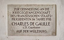
During the First World War , the Wülzburg was used as a prisoner of war camp. In 1918, the future French President Charles de Gaulle was imprisoned here until the end of the war in November 1918 (although this was interrupted by an attempt to escape). A commemorative plaque is located inside the doorway. On June 20, 1929, the first school camp in Bavaria was opened on the Wülzburg . During the Second World War , the Wülzburg was an internment camp , which is why the so-called Russian cemetery is located at the Fallgarten , in which, in addition to the graves of 40 Soviet trading sailors , the grave of the Prague composer Erwin Schulhoff can be found.
After the Second World War, the Wülzburg was a refugee camp , from 1952 to 1968 a district retirement home in the state south wing . In 1968 the Wülzburg received the status of a nationally significant architectural monument as an excellently preserved Renaissance fortress . The fortress has been renovated since 1969. Today, the building of the palace is home to a vocational school for special educational support, with a focus on learning, which is managed by the Rummelsberger Diakonie .
21st century
Up until around the year 2000, costs for the maintenance and restoration work on the fortress, which is almost entirely owned by the city of Weißenburg, were paid for by the Free State of Bavaria , the district of Middle Franconia and the current budget of the city of Weißenburg. Several million marks or euros were invested annually in safeguarding the company's existence.
After the Free State and the district have cut or stopped their grants, the city of Weißenburg no longer sees itself in a position to maintain the building fabric in its previous form. It can only raise around 350,000 euros per year. At the city’s New Year’s reception in 2006, the mayor at the time, Reinhard Schwirzer, quoted the opinion of an engineering office that in the future, due to the lack of money, one should think about deliberately no longer preserving parts of the fortress and letting it collapse. This caused quite a stir and it was possible to initiate an extensive renovation campaign worth several million euros in the coming years.
Building description
architecture
The 73,000 square meter fortress is an almost regular pentagonal bastionary complex in the New Italian style. This shape allows the fortress to be defended without any blind spots . The five bastions have the names from the entrance in the south, counterclockwise: Jungfrau, Krebs, Roßmühle, Kaltes Eck and Hauptwache. The entire system is built from the limestone, the dry trench, which is up to 10 meters deep and 23 meters wide, is partly carved out of the rock and partly created by backfilling the slope. From June 25, 1588, construction of the trench began.
Only the two-winged palace in the south and west of the inner courtyard development, which was rich in the 17th to 19th centuries, has survived, as well as a commercial building from 1814 south of the center of the courtyard. There is also a Deutsche Bundesbahn relay station in the inner courtyard . An approximately 50 meter high radio mast at the relay station was dismantled in 2007. The large casemates in the bastions, some of which are over 6 meters high, are remarkable . The highlight is the domed hall of the former Roßmühle with a diameter of more than 14 meters.
The covered path around the fortress with its arsenal from the 18th century is very well preserved at the Wülzburg, an exceptional case among German fortresses, where these outermost defensive structures were often the first to be leveled. On the Wülzburg, the covered path consists of a dry stone wall, some of which is taller than a man, which was previously reinforced with palisades. In recent years, the city of Weißenburg has begun to renovate this covered path and to repair the collapses. In addition, some of the trees on the glacis were felled so that the mountain fortress can be seen from afar - the construction is also easier to experience and understand on the 1-kilometer tour.
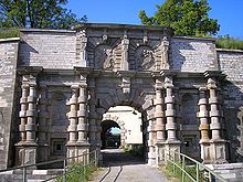
After the portal, built as a ceremonial gate, with the coat of arms of Margrave Georg Friedrich II. And his wife Sophie depicted on it, there is a representative riding ramp from the 16th century, which leads up to a large angular pillar to the attic.
On the gun platform of the Jungfrau Bastion there is a water tank built around 1900 to supply the fortress and the neighboring hamlet with water. At three of the five bastions there are square guard towers that allow a view of the glacis. At the Hauptwache bastion there is the hexagonal Hauptwache with an onion roof .
A road embankment, which was built in 1882, leads to the entrance gate; previously there was a wooden bridge.
Well and cistern
The deep well in the west wing originally served as the water supply . At 143.2 meters (after exposure), it is one of the deepest fortress wells in Germany. It was created around the year 1600 and has a diameter of 2.5 meters. Between 1823 and 1831 six rainwater cisterns were built by the Kingdom of Bavaria (according to plans by the Bavarian chief engineer Franz von Hörmann ); five of them in the ramparts, the largest cistern in the center of the courtyard. This, called the Ludwigszisterne (after King Ludwig I of Bavaria ), was the largest of its kind in the entire kingdom and is still a top product in engineering today. The Ludwigszisterne holds 1.3 million liters, which can be taken from four pump wells and four draw wells.
Memorials
There are several memorial sites on the Wülzburg Fortress . On February 15, 1997, the memorial to the expulsion of the Germans after the Second World War was inaugurated as a central memorial in the Weißenburg-Gunzenhausen district. The names of numerous Silesian, Prussian and Sudeten German places are engraved on several plates. A plaque commemorates the prisoner of war and later President Charles de Gaulle. An obelisk reminds the other prisoners of war of the First World War . A bust in front of the main building, inaugurated on October 2, 2004, commemorates Erwin Schulhoff .
Castle chapel and other buildings
The small Protestant church of St. Nicholas in the south wing of the palace was built around 1605. The interior of the church dates from 1738 and 1864. With just under 20 members, the church has the smallest parish in Bavaria.
Guided tours are offered through the fortress, which is owned by the city of Weißenburg. A restaurant is housed in a building erected in 1652/1662. Between 1986 and 1979 the main building was converted into a vocational school for care and assistance for the elderly as well as child care of the Rummelsberger Diakonie .
From the Wülzburg the program is broadcast by Radio 8 on 88.5 MHz with 50 W ERP . The 40 m high transmission mast / tower stands at a height of 629 m .
Parish village of Wülzburg
South of the fortress, shortly before its entrance, lies the parish village of Wülzburg with a few houses and its own cemetery, which is an officially named part of the municipality of Weißenburg.
Houses on the Wülzburger Berg
To the west below the fortress lies the Weißenburg part of the community, Häuser am Wülzburger Berg , which is also known as the Wülzburg settlement . The settlement is located at heights between 445 m and 500 m in the gusset between the federal highway 13 and the eastern bypass. The Aumühle , the Birkhof , the Glaserhaus and the summer cellar are located near the settlement . To the south of it are the Erlweiher , the old bathing pond and the sheep pond . From Weißenburg, the houses on the Wülzburger slope are only separated by the bypass road (common section of federal highways 2 and 13).
See also
literature
- Wülzburg. In: Gotthard Kießling: City of Weißenburg i. Bay. (= Monuments in Bavaria. Volume V 70/2). Edition Lipp, Munich 2001, ISBN 3-87490-582-9 , pp. 269-281.
- Thomas Biller: The Wülzburg. Architectural history of a renaissance fortress . Deutscher Kunstverlag, Munich 1996, ISBN 3-422-06154-1 (PDF; 140 MB).
- Johann Kaspar Bundschuh : Wülzburg . In: Geographical Statistical-Topographical Lexicon of Franconia . tape 6 : V-Z . Verlag der Stettinische Buchhandlung, Ulm 1804, DNB 790364328 , OCLC 833753116 , Sp. 299-300 ( digitized version ).
- Daniel Burger : The state fortresses of the Hohenzollern in Franconia and Brandenburg in the age of the Renaissance (= series of publications on Bavarian state history. Volume 128). Munich 2000, ISBN 3-925162-20-8 , pp. 130-182.
- Daniel Burger: Weißenburg in Bavaria. Wülzburg Fortress (= castles, palaces and fortifications in Central Europe. Volume 10). Schnell & Steiner, Regensburg 2002, ISBN 3-7954-1475-X .
- Florian Koch: Securing the Wülzburg Fortress. In: Monument preservation information. No. 141, November 2008, ISSN 1863-7590 .
- Wilhelm Korte: Old and new about Wülzburg. Ansbach 1869.
- (Wilhelm Korte): Wülzburg Monastery. In: Annual report of the Historical Association for Middle Franconia. Volume 36. Historischer Verein für Mittelfranken, Ansbach 1868, pp. 1-53 ( digitized version ) [largely identical to the chapter in the monograph by the same author in 1869, s. O.].
- Gerhard Leidel: History of the Benedictine Abbey Wülzburg (= Middle Franconian Studies. Volume 4). Historical Association for Middle Franconia, Ansbach 1983.
- Gerhard Leidel: The parishes of the Wülzburg monastery (= individual works from the church history of Bavaria. Volume 61). Degener, Neustadt a. d. Aisch 1986, ISBN 3-7686-4113-9 .
- Hartwig Neumann : The fortress Wülzburg. Forays through the past and present of the former Ansbach fortress. Lühker, Weißenburg 1980, ISBN 3-921354-07-2 .
- Otto Rieder : History of the former imperial city and imperial maintenance Weißenburg am Nordgau. Volume 1. Braun and Elbel, Weißenburg 2002, pp. 729–768 [printing of a manuscript from around 1900–1920, but with regard to Weißenburg absolutely thorough and fundamental source work by the former Bavarian Reich Archives Council].
- Gottfried Stieber: Wülzburg . In: Historical and topographical news from the Principality of Brandenburg-Onolzbach . Johann Jacob Enderes, Schwabach 1761, p. 975-991 ( digitized version ).
- Georg Voltz: Chronicle of the city of Weissenburg in Nordgau and the Wülzburg monastery. With 10 lithographed sheets by Fraulein Amalie v. Peters . Weissenburg 1835 ( full text ).
- Gotthard Kießling: Weissenburg-Gunzenhausen district (= Bavarian State Office for Monument Preservation [Hrsg.]: Monuments in Bavaria . Volume V.70 / 1 ). Karl M. Lipp Verlag, Munich 2000, ISBN 3-87490-581-0 .
Web links
- The Wülzburg Fortress ( Memento from May 16, 2003 in the Internet Archive ), on wug2000.de
- Hohenzollern Fortress Wülzburg , on weissenburg.de
- Wülzburg , basic data and history: Wülzburg - murder and manslaughter in the abbey in the database of monasteries in Bavaria in the House of Bavarian History
- Location of the fortress Wülzburg in the Bavarian Atlas of the Bavarian State Government ( information )
Individual evidence
-
↑ a b Map services of the Federal Agency for Nature Conservation ( information )
- Map service landscapes shows the boundaries of individual partial landscapes and makes landscape profiles with area information (80xxx = northern, 81xxx = middle, 82xxx = southern Franconian Alb) clickable
- Map service for protected areas shows mountain heights down to TK 25;
Nature reserves, FFH areas, nature parks (each with area information), main units and communal boundaries can be displayed - The height above sea level from Wülzburger Berg ( 620 m ) should not be confused with the platform height of the Roßmühle bastion ( 643.8 m )
- ↑ Topographic map : Wülzburger Berg with the Wülzburg , on the Bavarian Atlas of the Bavarian State Government ( references )
- ↑ Map services of the Federal Agency for Nature Conservation ( information )
- ↑ Alfred Kriegelstein: Tell legends stories from Middle Franconia. 1983, ISBN 3-7689-0203-X , p. 233 f.
- ↑ a b c Christine Riedl-Valder: Wülzburg - history. In: Monasteries in Bavaria. House of Bavarian History , accessed on March 22, 2018 .
- ^ Peter Wanner: The Staufer-Castilian marriage pact of the year 1188. Findings on the occasion of some "small" district and community anniversaries in 2013 . In: Christhard Schrenk / Peter Wanner (eds.): Heilbronnica 6. Contributions to the city and regional history . Heilbronn 2016, pp. 453–460, here: pp. 458–459 (PDF; 366 KB).
- ^ Die fortress Wülzburg ( memento of October 24, 2009 in the Internet Archive ), description, on wug2000.de
- ↑ Weißenburg, the Wülzburg and Stopfenheim , on gottiswelt.de
- ^ City history of Weißenburg , on fraenkisches-seenland.bayern-online.de
- ↑ Russian Garden , on wugwiki.de
- ^ Mammoth project Wülzburg , on nordbayern.de
- ↑ Hohenzollern Fortress Wülzburg (Schenk's Palaces and Gardens), on schlösserundgärten.de
- ↑ Hohenzollern Fortress Wülzburg , on Urlaubsregion-altmuehltal.de
- ↑ a b c d The Wülzburg. Monument conservation group Wülzburg, archived from the original on February 5, 2012 ; Retrieved January 25, 2012 .
- ^ Wülzburg Weißenburg ( Memento from April 14, 2013 in the Internet Archive ), on ausflugsziel-weltweit.de
- ↑ Wülzburg - Memorials , accessed on January 27, 2016
- ↑ Wülzburg-Kapelle St Nikolaus , accessed on January 27, 2016, from st-andreaskirche.de
- ↑ 88.5 Weißenburg (FMMAP database entry), on fmscan.org
- ^ Wülzburg in the location database of the Bavarian State Library Online . Bavarian State Library
- ↑ Houses a.Wülzburger Berg in the database of the Bavarian State Library Online . Bavarian State Library


