
Great Dhünntalsperre
| Great Dhünntalsperre | |
|---|---|
| Data | |
| Geographical coordinates of the dam: | 7 ° 11 ′ 11 ″ East 51 ° 04 ′ 03 ″ North |
| Data structure | |
| Construction time of the pre-dam Große Dhünn (formerly Dhünntalsperre ): | 1960–1962 |
| Construction time Great Dhünntalsperre : | 1975-1985 |
| Trial jam: | November 1984 to April 1987 |
| Installation: | 1988 |
| Data reservoir | |
| Total storage space: | 81 million m³ |
| of which pre-barrier Große Dhünn : | 7.5 million m³ |
| of which pre-barrier Kleine Dhünn : | 0.4 million m³ |
| of which pre- and inflow basins: | 0.3 million m³ |
| Annually Drinking water withdrawal: | 42 million m³ |
| Annually Extraction for raising the low water level: | 8 million m³ |
| Annually Infiltration and evaporation losses: | 6 million m³ |
| Flood retention: | 8.5 million m³ |
| Congestion destination: | 176.50 m above sea level NN |
| Water surface in the event of a full block | 440 hectares |
| Height above valley floor: | 53 m |
| Height above foundation level: | 63 m |
| Dam volume: | 1.2 million m³ |
| Crown length: | 400 m |
| Crown width: | 8.5 m |
| Base width: | 210 m |
| Radius of curvature: | No bend |
| Catchment area: | 60 km² |
| Catchment area including Sülz tributary: | 89 km² |
| Average annual inflow: | 44 million m³ |
| Average annual inflow including brine inflow: | 56 million m³ |
| Design flood: | 90 m³ per second |
| Design flood including brine inflow: | 115 m³ per second |
| Building-costs: | 286 million DM |
| of which land acquisition: | 64 million DM |
| Water treatment and distribution costs: | 255 million DM |
| Flood protection costs: | 14.5 million DM |
| Compensation and follow-up costs: | 12 million DM |


.jpg)
The Great Dhünntalsperre , fed by the two headwaters of the Dhünn River , is the largest drinking water dam in the west and the second largest drinking water dam in Germany. It is operated by the Wupperverband and is located in the Rheinisch-Bergisches Kreis between the cities and communities of Wermelskirchen , Wipperfürth , Kürten and Odenthal in the low mountain range Bergisches Land ( North Rhine-Westphalia ).
history
The older dam
The Great Dhünntalsperre is the extension of a much smaller dam in the Dhünntal, the Dhünntalsperre (storage volume: 7.5 million m³) , which was built 15 years earlier .
The water supply of groundwater poor Bergisch cities Wuppertal , Remscheid and Solingen was in the second half of the 20th century, despite each with its own drinking water reservoirs (Wuppertal: Herbringhausen Dam , Ronsdorf dam and Kerspe dam ; Remscheid: Eschbachtalsperre , Neyetalsperre and armored dam ; Solingen: Sengbach dam ) in the summer months cannot be guaranteed, so that the construction of the Dhünntalsperre was agreed with the Wupperverband at the end of the 1950s.
This dam was built in the years 1960–1962 and its dimensions were identical to today's pre- dam Große Dhünn . In the literature, this dam is often incorrectly referred to as the Kleine Dhünntalsperre . (See definition of terms and naming). The Sengbachtalsperre in Solingen recently received an inflow of 2.5 million m³ per year from the Dhünntalsperre. The city of Remscheid, the Rhein-Wupper Water Supply Association (WVV) and the Bergische Wassergenossenschaften were further buyers for the 8 million m³ of raw water withdrawn annually . The water treatment plants, which were commissioned from 1963 to 1964, had a capacity of 500 to 1,800 m³ per hour.
The younger dam
It quickly became apparent that the capacity of the Dhünntalsperre would not be sufficient for the future drinking water supply and after a double dry year, the expansion to the Great Dhünntalsperre was planned in 1971 (storage volume: 81 million m³). However, the first considerations about a building had been there since the 1940s.
The construction was on 22 April 1975, a first snap shot by the Minister of Food, Agriculture and Forestry of the country NRW , Diether Deneke began solemnly and ended 1985th
First the bottom outlet was built, through which the dhünn could flow unhindered during the construction phase of the dam. Relocation, demolition and clearing work followed. Then the dam and the water technology facilities were built. After a two-and-a-half year trial and cleaning backlog from November 1984 to April 1987, the dam was officially put into operation on September 30, 1988 with an inauguration ceremony.
With the completion of the Great Dhünntalsperre, all supply problems were permanently resolved; it is even integrated into the emergency care of the state capital Düsseldorf .
In 1984 a helicopter crashed into the dam. The aircraft was salvaged by the river pioneer company 850 of the Bundeswehr .
See also
- Great Dhünntalsperre nature reserve (south)
- Great Dhünntalsperre nature reserve (Great and Small Dhünn)
Explanation of terms and naming
The name of the Great Dhünntalsperre does not derive from its dimensions, but rather from its main tributary, the Great Dhünn stream, according to convention .
The older and smaller dam in the Dhünntal was referred to as the Dhünntalsperre , although according to the naming convention it should also have been called the Große Dhünntalsperre , as it was the only dam that dammed the Große Dhünn stream . Today this dam is the pre- dam Große Dhünn of the younger Große Dhünntalsperre . To distinguish it from the later built Great Dhünntalsperre , it is sometimes referred to as the Kleine Dhünntalsperre in the sense of smaller than .
The second main tributary of the Great Dhünntalsperre is the Kleine Dhünn stream . Although this is also dammed in the Kleine Dhünn pre- dam of the Great Dhünntalsperre , this is not identical to the smaller Dhünntalsperre , the older Dhünntalsperre, which is wrongly called this .
The storage system
Inflows and outflows
The streams Große Dhünn and Kleine Dhünn represent the largest tributaries. The Große Dhünn rises near the Wipperfürth village of Peddenpohl , flows straight through its wooded brook valley and joins the Purder Bach shortly before the dam . The Kleine Dhünn rises near Dreibbaum on the border of Hückeswagen and Wermelskirchen and flows into the dam shortly after the Wermelskirchen town of Dhünn . The triangle spanned by the two tributaries is only sparsely populated, very densely wooded and thus ensures a high quality of the water input into the dam. In order to be able to maintain this condition, the area was designated as water protection zones IIb and III.
Both tributaries are dammed up in rather large pre- dams , with the Große Dhünn pre- dam being a previously independent dam. The Dhünn outflow is the largest tributary of the Wupper and flows into it in Leverkusen .
Other larger tributaries are: Frenkhausener Bach , Hohemühlenbach , Ledderbach , Oberstockberger Bach and Viersbach .
Sülzüberleitung
The Great Dhünntalsperre is connected to the river system of the Kürten Sülz by a 3,100 meter long transfer tunnel with a diameter of 3.35 m . This feed line increases the annual inflow of 44 million m³ by a further 12 million m³ to 56 million m³. The transfer tunnel begins at the Kürten town of Häcksbilstein and flows into the dam of the Große Dhünn pre- dam .
On average, the Kürtener Sülz is only transferred on 200 days a year, as water is only drawn from the Kürtener Sülz at a minimum flow rate of 0.435 m³ / s. The maximum transfer is 25 m³ / s. The gradient between inlet and outlet is 10 m, the ridge between the stream valleys of the Große Dhünn and the Kürtener Sülz rises 90 m above the transfer tunnel.
Pre-blocking, pre- and inflow basins
In addition to the two pre- dams Large Dhünn pre- dam (storage volume: 7.5 million m³) and Kleine Dhünn pre- dam (storage volume: 0.4 million m³), the dam has 15 further water management pre- basins and ecological inlet basins (total accumulation volume : 0.3 million m³ ), which serve the sedimentation and the nature and species protection:


| Pre-blocking, pre- and inflow basins (Clockwise from the dam) |
||
|---|---|---|
| Surname | Catchment area | Traffic jam |
| Engerfeld inlet basin | 0.47 km² | 2,000 m³ |
| Schaffeld inlet basin | 0.19 km² | 13,600 m³ |
| Malsberg inlet basin | 0.44 km² | 3,200 m³ |
| Hundhagen inlet basin | 0.38 km² | 6,900 m³ |
| Frenkhauser Bach inlet basin | 1.21 km² | 12,000 m³ |
| Pre-blocking Kleine Dhünn | 14 km² | 0.4 million m³ |
| Inlet basin Am Rottfeld | 0.21 km² | 6,800 m³ |
| Pre-blocking Große Dhünn | 30 km² | 7.5 million m³ |
| Hutsherweg inlet basin | 0.28 km² | 5,100 m³ |
| Vorbecken Oberstockberg | 0.73 km² | 24,900 m³ |
| Richerzhagen pre-basin | 1.02 km² | 51,300 m³ |
| Forebay Müllberg / four Bach | 0.59 km² | 63,300 m³ |
| Front basin Hohemühle | 2.08 km² | 80,000 m³ |
| Inlet basin on the Örtgen | 0.15 km² | 2,200 m³ |
| Great Heath inlet basin | 0.51 km² | 37,400 m³ |
| Eichholz inlet basin | 0.24 km² | 4,900 m³ |
| Breibacher Berg inlet basin | 0.16 km² | 7,500 m³ |
Purpose of the dam

In addition to the production of 42 million m³ of drinking water per year, the dam serves to supply approx. 500,000 people as well as raising the low water level and providing protection against flooding (8.5 million m³ retention capacity) for the Dhünn and the lower Wupper area. The controlled water extraction from the Kürtener Sülz also serves to protect the river from flooding.
The dam is dimensioned in such a way that excess water can be absorbed over a long period of time when it is raining, in order to be able to release it again in years with little rain. A dam with this type of storage is also known as an annual storage facility .
The water withdrawal is divided into the following contingents:
-
Rhine-Wupper Water Supply Association (WVV)
- 6.0 million m³
- The WVV supplies the towns and communities of Radevormwald , Leichlingen (Rhineland) , Hückeswagen , Wermelskirchen , Burscheid and Odenthal via the Schürholz drinking water treatment plant in nearby Wermelskirchen- Dabringhausen .
-
Bergischer Trinkwasserverbund GmbH (BTV)
- Wuppertal : 12.0 million m³
- Remscheid : 9.0 million m³
- Solingen : 8.8 million m³
- Leverkusen : 6.2 million m³
Dam and water engineering facilities

dam
The barrier structure below the village of Lindscheid in Wermelskirchen is a rubble dam with an asphalt concrete core seal. The stone fill is layered: the inner area has a maximum grain size of 300 mm in diameter, the outer area a maximum grain size of 600 mm.
The water side is thinly coated with coarser rock and the side facing away from the water has been planted. The subsurface was provided with an injection seal. The crown is 400 m long and 8.5 m wide. The dam wall is 210 m wide at the bottom.
The dam has an inspection passage in the hearth wall and is constantly checked for stability and functional reliability by means of a complex network of sensors and measuring points. Access to the inspection passage is possible from both ends of the dam and via a cross passage from the stilling and equalization basin below the dam.
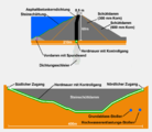
The bottom outlet tunnel has a mouth profile measuring 4.00 × 2.54 m. It is built into the base of the raw water extraction tower.
Flood protection
The flood relief tower with overflow funnel has a maximum diameter of 20 m, which tapers to four meters towards the flood relief tunnel. Flow pillars and a ventilation device ensure a controlled overflow into the stilling basin.
Raw water extraction
The raw water extraction tower rises 66 m above the foundation level not far from the overflow funnel and the dam wall. It can be reached via a 140 meter long bridge. In the raw water extraction tower there are inlets at intervals of five meters that allow controlled extraction from different water levels depending on the water quality (water temperature, conductivity, pH value, turbidity and oxygen content). The water is fed from here to the raw water pumping station behind the dam and from there, with the help of five pumps, is pumped into the treatment plants in the Wermelskirchen town of Dabringhausen-Schürholz. The long-distance water system has three pumping stations and a transport line length of 50 km.
Thermal trunk
Since 2014 the raw water extraction tower has had an additional swiveling extraction arm. This approximately nine meter long so-called thermal trunk is attached with a rotary joint at the extraction tower and can be in a range of 14 meters in various warm water layers are moved. The water withdrawn in this way is passed through an additional withdrawal and motive water pipe with a nominal width of 700 mm in the raw water withdrawal tower through two flow turbines and then fed into the bottom outlet. By mixing the water from the upper water layers, which is warmer in the summer months, and the cold deep water from the bottom outlet of the dam, the water temperature in the lower reaches of the Dhünn should be brought into line with the water temperatures of the inflows of the dam. This should improve the living conditions for the animal and plant species in the lower reaches of the Dhünn (see Ichthyofauna ). The thermal trunk is the first project of its kind in Europe. The hydropower plant generates an annual energy turnover of around one million kilowatt hours .
Others
The company building of the Wupperverband, to which an information center is attached, is located near the dam.

Bottom outlet , water extraction tower and flood relief tower with overflow funnel of the Great Dhünntalsperre
Cross-section and longitudinal section of the dam

Cross-section of a flood relief tower with an overflow funnel


ecology
It is thanks to the late construction at the end of the 20th century that ecological aspects were taken into account in the construction to a large extent. The upstream and inflow basins were also set up as spaces for nature and species protection, such as B. in the form of swimming islands as breeding grounds for water birds.
The dam, located in a nature reserve , is extensively surrounded by a 760 hectare water protection forest ( water protection zone IIa), through which a large number of natural, marked hiking trails lead. Only these hiking trails are exempt from entering the 100 meter wide protection zone strip (water protection zone I) around the dam. In addition to water protection, it also serves as a quiet zone for the local flora and fauna.
flora
.JPG)
The measures were completed by the planting of native water, floating leaf and marsh plants such as. B. rushes , reeds , glossy grass , cane and cattail stocks . High herbaceous species quickly established themselves.
The forest consists mainly of spruce and deciduous forest stands . In the deciduous forests, beech - oak forests ( Fago-Quercetum ), acidic beech forests ( Luzulo-Fagetum ) and birch- oak forests ( Betulo-Quercetum ) dominate, as well as, to a limited extent, birch pioneer forests , pedunculate oaks , occasionally sessile oak and alder along the tributaries of the streams.
Bracken , bilberry , pipe grass and wire-smiths settle in the undergrowth of the deciduous forests . English gorse has colonized a small open space south of the dam.
Berchtold's dwarf pondweed ( Potamogeton berchtoldii ) and chandelier algae ( Characeae nitella ) were detected in the ecological inlet basins . Common heather or gorse heather conquer bank slopes.
In specialist circles, finds of rare mushrooms such as summer boletus ( Boletus reticulatus ) and crooked scapula ( Pholiota tuberculosa ) are reported. Over 30 species of hat mushroom have been registered.
Fallow wet meadows in the shore zone were populated or covered with bushes by herds of bracken, knotweed , tall perennials and forest rushes.
Avifauna

Of the 80 bird species that breed at the Great Dhünntalsperre, almost 20 are on the red list of threatened animal species , including species such as the little grebe, tree falcon, honey buzzard, red kite, barn owl, black stork, black woodpecker, green woodpecker, gray woodpecker, small woodpecker, common raven, kingfisher, Little ringed plover, red backed killer, and dipper.
Over the years, the islands in the ecological reservoirs, which were created to protect flora and fauna, have mostly been covered with bushes and weeds. The little ringed plover (picture opposite) therefore only breeds in the gravel substrate of the rinsing areas when the water is low. It can be 3–5 couples in dry years, especially on the north bank.
The more interesting migrants and winter guests include black-throated divers, osprey, sandpiper, black tern, goosander, dwarf warrior, greenshank, redshank, gray shrike, marsh harrier, hen harrier, wagtail, stonechat, whinchat, wheatear, sandpiper, wood sandpiper,
Herpetofauna

Specially set up ponds form a home for amphibians. Further ecological measures are rock and scree biotopes as a habitat for reptiles, differently designed shore zones from flat banks to steep banks and shallow water zones.
- Common toad , common frog , grass snake , forest lizard
Ichthyofauna

However, from an ecological point of view, the dam has a partially negative effect on the aquatic fauna. The dam as such interrupts the course of the Dhünns brook and thus forms an insurmountable barrier for fish to migrate into the upper reaches. The once native salmon will not be able to reach their preferred spawning grounds in the upper reaches , despite the extensive measures to settle in the Rhine and its tributaries, the dam represents a sharp dividing line between the aquatic fauna above and below the dam.
The water volume and temperature balance of the Dhünn runoff is significantly changed by the dam. If the water quality in the runoff is almost drinking water quality, the water taken from the bottom outlet is too cold for the Dhünn for a water fauna as it would be without this entry. The increase in the low water level leads to a change in the runoff dynamics and also affects migration and settlement behavior.
By retrofitting a so-called thermal trunk, a natural adjustment of the water temperatures in the lower reaches of the seasonal water temperatures of the dam inflows should be achieved. This technical measure is intended to balance the interference in the temperature balance with the ecological consequences for biodiversity. (See thermal trunk )
In the dam, and the tributaries there is one for the type of water (After Illies Epihithral , Metahithral and Hyporhithral ) typical regional colonization of brown trout and bullheads . Without a barrier, this type of water would be a more typical settlement area for salmon and grayling with a reduced number of individuals of the species that are predominant today.
Entomofauna

Amongst other things:
- Dragonflies
- Great royal dragonfly ( Anax imperator ), azure damsel ( Coenagrion spec. ), Blue-green damsel ( Aeshna cyanea ), large pitch dragonfly ( Ischnura elegans )
- Butterflies
- Large cabbage white butterfly ( Pieris brassicae ), brimstone butterfly ( Gonepteryx rhamni ), brown forest bird ( Aphantopus hyperantus ), great ox-eye ( Maniola jurtina ), Hesperia spec.
- Bugs and bedbugs
- Back swimmer ( Notonecta spec. ), Water strider ( Gerris spec. ), Tumbler ( Gyrinus spec. ).
Mammals
Relevant stocks of brown hares and wild boars are to be reported.
Sunken places
Several villages, mills and farms were flooded and connecting roads were interrupted by the damming. This ended a demonstrably 1000-year history of settlement in the Dhünntal. Powder mills are documented around 1673 . Of the 67 demolished, partly historical buildings, 25 were used for agriculture.
For the 210 affected residents of the Dhünntal, many of whom have resisted the resettlement until the end, compensation in the form of pension payments and compensation land has been made. Shortly before the start of the trial construction, a big party was celebrated at which thousands of foreigners said goodbye together with the residents.
The following villages, mills and farms have sunk or demolished:


tourism
In addition to protecting the quality of the water, the Wupperverband also took into account the needs of the population for recreation and allowed restricted access to the dam. The dams of the two large pre-dams and the main dam are freely accessible and can be crossed on foot. Visitors can find out more about the dam in the information center.
Use of the dam is restricted to activities that can be walked on. Water sports activities, including fishing, are not permitted.
In 2007 and 2010, the Wupperverband and the Rheinisch-Bergischer Kreis organized the event "unverDHÜNNt". In addition to an extensive supporting program, guided hikes were made possible within the water protection zone I, which is otherwise not accessible. Up to 15,000 visitors took part in the events. Since then, it has been repeated every 3 years in September.
Hiking opportunities
In addition to the marked hiking trails of the Sauerland Mountain Association (SGV), the Wupperverband has designated its own hiking trails , set up information boards and issued a hiking map. Numerous specially set up parking spaces for hikers surround the dam.
- The hiking trails designated by the Wupperverband include circular hiking trails around the two pre-dams and around the entire dam. With a length of 40 km, this path is only recommended for ambitious hikers due to its length.
- A large number of marked smaller local circular hiking trails of the individual SGV departments of the surrounding cities touch the dam or lead through its protective forest.
- The main hiking route X29 of the Sauerland Mountain Association, called Bergischer Weg , crosses the dam and then accompanies the western dam for many kilometers to the Hohemühle feed basin .
- The SGV hiking trail around the city limits of Kürten: called Kürtenring , follows the entire southern bank line of the dam and the pre- dam Große Dhünn .
- The SGV hiking trail around the city limits of Wermelskirchen follows almost the entire northern shoreline of the dam and the Kleine Dhünn dam .
- The SGV hiking trail from Burg Castle to the Wermelskirchen village of Halzenberg runs along the northern shore path of the Große Dhünn pre-dam .
In the summer of 2013 a new circular route around the pre-dam was opened.
Reservoir tours
The Wupperverband regularly offers tours of dams. Every year 3,000 to 4,000 guests from all over the world get to know the water in this way. These tours are also increasingly aimed at school classes in the region.

literature
Information brochures and cartography
- Festschrift for the inauguration of the Dhünntalsperre: June 14, 1962, published by the Wupperverband
- Commissioning of the Great Dhünn Dam and long-distance water supply Great Dhünn Dam, publisher: Energieversorgung Leverkusen; Wuppertal public utilities; Wupper Association, 1988
- Information brochure "Great Dhünntalsperre" from the Wupper Association
- Hiking map 1: 15,000 with explanations “Hiking around the great Dhünn dam”, published by the Wupperverband
Settlement history
- Manfred Rech: Excavations in the area of the Great Dhünntalsperre near Wermelskirchen-Dabringhausen, Rhein.-Berg. Circle. In: Excavations in the Rhineland. Rheinisches Landesmuseum Bonn, 1983, ISBN 3-7927-0698-9 , pp. 219-224.
- Dirk Soechting: Early settlement in the area of the Great Dhünn Dam. In: Romerike Berge. 1990
- Martin Jeremias, Ursula Schmidt-Goertz: The Dhünntalsperre washes the millennia free: new soil finds at low water; Research continues. In: Rhein.-Berg. Calendar. 66. 1996 (1995) pp. 57-64: Ill.
- NJ Breidenbach: Loosenau. In: Altenberger Blätter. Issue 35, Odenthal 2006.
- NJ Breidenbach: The Königsspitzer Hof near Kürten. In: Kürtener Schriften (ed.): Kürtener Geschichtsverein , Heft 6, Kürten 2007.
- M. Jendrischewski: People and history (s) of a sunken landscape, the courts of the upper Dhünntal. Verlag Jendrischewski, Lindlar 2009, ISBN 978-3-00-029572-0 .
- NJ Breidenbach: Old courtyards and houses in the Wupperviereck ... Wermelskirchen 2011, ISBN 978-3-9802801-2-9 .
ecology
- Borggreve: Technical contribution to the landscape plan of the Great Dhünntalsperre, sub-area 3 of the Rhein.-Bergisches Kreis according to [Paragraph] 17, Paragraph 3 of the Landscape Act NW. Higher Forest Authority Rhineland, Bonn, State Forestry Office Königsforst 1978
- Hartmut Osing: The Great Dhünntalsperre and its bird life: surprises between water, banks, gravel and forest; a balance sheet. In: Rhein.-Berg. Calendar. 64. 1994 (1993) pp. 36-42: Ill.
- Michael Schmitz, Hartmut Osing: Effects of the construction of the Wupper and Great Dhünn dams on the avifauna: with comments on the function of the compensatory and replacement measures. 1999.
- Hartmut Osing: The little ringed plover. Verlag Natur und Wissenschaft, Solingen 1993.
Hydrology and geology
- H. Kisseler: Drinking water supply from the Great Dhünn Dam: transition from d. Construction phase to operating phase. In: Local Services. 1984.
- Manfred Horn, Jürgen Mencke, Eva Paproth: Preliminary information on rock investigations in the Sülz transfer tunnel to the Great Dhünn Dam in the Rheinisch-Bergisches Kreis. In: The Lower Rhine. 1986.
- Remzi Karagüzel: About mountain permeability and underground injections at the Great Dhünn dam and its pre-dams. Chair of Engineering Geology a. Hydrogeology d. RWTH, Aachen 1989.
Web links
- The Wupper Association
- Image of the dam construction
- Image of the construction of the flood relief systems
- Dams directory NRW (PDF; 121 kB)
- Dams in North Rhine-Westphalia; State Environment Agency NRW
- High medieval iron smelting and processing in the Bergisches Land (short message)
- Video: The fascination of the Dhünntalsperre - aerial photographs over the course of the year
See also
Individual evidence
- ↑ a b Wolfgang Weitzdörfer: Thermo trunk opened at the dam. In: Rheinische Post. April 16, 2015, accessed March 22, 2018 .
- ↑ a b Andreas Pointinger: “Thermorüssel” feeds through-flow twins. In: zek Hydro. Gruber-Seefried-zek Verlag, February 17, 2015, accessed on March 22, 2018 .
- ↑ a b Thorsten Luckner: Temperature adjustment of the discharge from the Great Dhünn Dam - First results of the thermal trunk. (PDF; 2.5 MB) Wupperverband, June 2016, p. 6 ff. , Accessed on March 22, 2018 .
- ↑ undiluted - pure nature! Rheinisch-Bergischer Kreis, accessed on February 19, 2018 .
- ↑ Hiking experience around the Vorsperre - The circular path around the Vorsperre Große Dhünn is open. Rheinisch-Bergischer Kreis, accessed on August 11, 2013 .
Coordinates: 51 ° 4 ′ 27 ″ N , 7 ° 12 ′ 50 ″ E