Three trees
|
Three trees
City of Hückeswagen and Wermelskirchen
Coordinates: 51 ° 8 ′ 1 ″ N , 7 ° 16 ′ 19 ″ E
|
||
|---|---|---|
| Height : | 320 m above sea level NN | |
| Residents : | 90 | |
| Postcodes : | 42499 (HW), 42929 (WK) | |
| Primaries : | 02192 (HW), 02196 (WK) | |
|
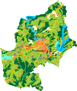
Location of three trees in Hückeswagen |
||
Dreibäum is a place in the administrative district of Cologne in North Rhine-Westphalia (Germany), which partly belongs to Hückeswagen in the Oberbergisches Kreis and partly to Wermelskirchen in the Rheinisch-Bergisches Kreis .
Location and transport links
Dreibäum is located in the western Hückeswagen and eastern Wermelskirchen, as the district boundary runs in a north-south direction through the middle of the village. Neighboring places are Strucksfeld , Stoote , Wermelskirchen-Oberdurholzen and Wermelskirchen-Oberhebbinghausen. The state roads L101 and L80 intersect in the village.
The place lies on the watershed between the Wupper and the Dhünn . The Dörpe brook, which rises to the north, flows into the Wuppertalsperre , while the source brooks of the Kleine Dhünn spring to the south . The 72-hectare area of the golf course of the same name , which was built between 1998 and 2000, begins immediately on the northeastern border .
history
The place was mentioned for the first time in 1829 , the spelling of the first mention was three trees . In 1815/16, according to an official register from the year 1835, there were already eleven residents in the village.
In 1832, as a border town, Dreibäum belonged partly to the upper honors Wermelskirchen of the mayor's office of Wermelskirchen and partly to the great honors , which was part of the Hückeswagen external citizenship within the mayor's office of Hückeswagen . The place, which was categorized as a hamlet and day laborer's apartment according to the statistics and topography of the Düsseldorf administrative district , had three residential buildings (all three in Wermelskirchen) and four agricultural buildings (all four in Wermelskirchen) at that time. At that time, 24 residents lived in the place, four Catholic and 20 Protestant denominations.
The municipal and estate district statistics of the Rhine Province lists Dreibäum 1871 with ten residential houses (three for the upper honors and seven for the great honors) and 87 inhabitants (31 for the upper honors and 56 for the great honors). In the municipality lexicon for the province of Rhineland , twelve houses (four or eight) with 77 inhabitants (26 and 51) are given for 1885. At that time the place belonged partly to the city of Wermelskirchen and partly to the rural community Neuhückeswagen , both within the Lennep district . In 1895 the place had 13 houses (five or eight) with 83 inhabitants (33 or 50), in 1905 13 houses (four or nine) and 84 inhabitants (30 or 54).
Hiking and biking trails
The following hiking trails lead through the village:
- The SGV main hiking route X19 ( Schlösserweg ) from Düsseldorf to Dillenburg
Web links
Individual evidence
- ^ Klaus Pampus: First documentary naming of Oberbergischer places (= contributions to Oberbergischen history. Sonderbd. 1). Oberbergische Department 1924 eV of the Bergisches Geschichtsverein, Gummersbach 1998, ISBN 3-88265-206-3 .
- ↑ a b Johann Georg von Viebahn : Statistics and topography of the administrative district of Düsseldorf. Part 2: Containing the statistical table of places and distances and the alphabetical index of place names. Carpenter, Düsseldorf 1836.
- ↑ Royal Statistical Bureau Prussia (ed.): The communities and manor districts of the Prussian state and their population . The Rhine Province, No. XI . Berlin 1874.
- ^ Royal Statistical Bureau (Prussia) (Ed.): Community encyclopedia for the Rhineland province. Based on the materials from the census of December 1, 1885 and other official sources (= community encyclopedia for the Kingdom of Prussia. Vol. 12, ZDB -ID 1046036-6 ). Publishing house of the Royal Statistical Bureau, Berlin 1888.
- ^ Royal Statistical Bureau (Prussia) (Ed.): Community encyclopedia for the Rhineland province. Based on the materials from the census of December 1, 1895 and other official sources (= community encyclopedia for the Kingdom of Prussia. Vol. 12). Publishing house of the Royal Statistical Bureau, Berlin 1897.
- ^ Royal Statistical Bureau (Prussia) (Ed.): Community encyclopedia for the Rhineland province. Based on the materials from the census of December 1, 1905 and other official sources (= community encyclopedia for the Kingdom of Prussia. Vol. 12). Publishing house of the Royal Statistical Bureau, Berlin 1909.

