
Neuenherweg (Hückeswagen)
|
Neuenherweg (Hückeswagen)
City of Hückeswagen
Coordinates: 51 ° 10 ′ 27 ″ N , 7 ° 21 ′ 36 ″ E
|
||
|---|---|---|
| Height : | 356 m above sea level NN | |
| Postal code : | 42499 | |
| Area code : | 02192 | |
Location of Neuenherweg (Hückeswagen) in Hückeswagen |
||

Neuenherweg is a village in Hückeswagen in the Oberbergischer Kreis in the administrative district of Cologne in North Rhine-Westphalia ( Germany ).
Location and description
Neuenherweg is located in northeastern Hückeswagen near the Bevertalsperre at the intersection of the federal highway 483 (B483) and the district road K11. Other neighboring towns are Herweg , Zipshausen , Heinhausen , Eckenhausen , Niederdahlhausen , Linde , Niederbeck , Mittelbeck and Funkenhausen .
Two source brooks of the Neuenherweger Bach arise to the west of the village .
history
The place was mentioned for the first time in 1532 : Gerardt, his wife and son to dem Heyde in the Heirdinxfelder Honschaft are named in a list of residents. Spelling of the first mention: to dem Heyde , apparently the place has been renamed.
In the municipality lexicon for the province of Rhineland in 1885 four houses with 25 inhabitants are given. At that time the place belonged to the rural community Neuhückeswagen within the Lennep district . In 1895 the place had four houses with 22 inhabitants, in 1905 seven houses and 41 inhabitants.
Neuenherweg is located on the Hückeswagen – Radevormwald section of a medieval military , trade and pilgrimage route , today's federal road. The current place name is derived from this Heerweg.
Hiking and biking trails
The following hiking trails lead through the village:
- The SGV main hiking route X7 ( Residenzenweg ) from Arnsberg to Düsseldorf-Gerresheim
- The local hiking trail ▲ from the center of Radevormwald to Purd
- The Hückeswagen local circular hiking trail A3 (Frohnhauser Bachtal)
- The Radevormwald local circular hiking trail A2 (Hölterhof)
Location views
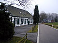
View of Neuenherweg

Memorial stone in Neuenherweg


Individual evidence
- ^ Klaus Pampus: First documentary naming of Oberbergischer places (= contributions to Oberbergischen history. Sonderbd. 1). Oberbergische Department 1924 eV of the Bergisches Geschichtsverein, Gummersbach 1998, ISBN 3-88265-206-3 .
- ^ Royal Statistical Bureau (Prussia) (Ed.): Community encyclopedia for the Rhineland province. Based on the materials from the census of December 1, 1885 and other official sources (= community encyclopedia for the Kingdom of Prussia. Vol. 12, ZDB -ID 1046036-6 ). Publishing house of the Royal Statistical Bureau, Berlin 1888.
- ^ Royal Statistical Bureau (Prussia) (Ed.): Community encyclopedia for the Rhineland province. Based on the materials from the census of December 1, 1895 and other official sources (= community encyclopedia for the Kingdom of Prussia. Vol. 12). Publishing house of the Royal Statistical Bureau, Berlin 1897.
- ^ Royal Statistical Bureau (Prussia) (Ed.): Community encyclopedia for the Rhineland province. Based on the materials from the census of December 1, 1905 and other official sources (= community encyclopedia for the Kingdom of Prussia. Vol. 12). Publishing house of the Royal Statistical Bureau, Berlin 1909.

Altenhof | Altenholte | Aue | Berbeck | Bergerhof | Bochen | Buck hoe | Böckel | Braßhagen | Bridge | Brunsbach | Buchholz | Bush | Busenbach | Busenberg | Dierl | Dörpe | Dkörpersteeg | Dörpfeld | Dörpfelderhöhe | Three trees | Dürhagen | Eckenhausen | Oak trees | Elbertzhagerhäuschen | Elberhausen | Engelshagen | Alder Ore | Fockenhausen | Frohnhausen | Forward | Drove | Funkenhausen | Goldenberg's Hammer | Großberghausen | Großeichen | Großenscheidt | Grand cat | Grünental | Grünestrasse | Hailstones | Halfmannsberghausen | Hambüchen | Hammerstein | Hangberg | Hartkopsbever | Heinhausen | Heydt | Heather | Heidt | Herweg | Height | Höhsiepen | Leguminous bush | Hummeltenberg | Junkernbusch | Käfernberg | Kaisersbusch | Kammerforsterhöhe | Karquelle | Karrenstein | Cherry syrups | Kleinberghausen | Small oaks | Kleinenscheidt | Kleinhöhfeld | Small cats | Knefelsberg | Kobeshofen | Kormannshausen | Kotthausen | Short field | Laake | Linden tree | Maisdörpe | Brand | Mickenhagen | Mitberg | Mittelbeck | Middle crest | Mühlenberg | Neuenherweg | Neuenholte | Neukretze | Niederbeck | Niederburghof | Niederdahlhausen | Niederdorp | Niederhagelsiepen | Niederhombrechen | Niederlangenberg | Niederwinterhagen | Oberbeck | Oberburghof | Oberdorp | Oberhombrechen | Oberlangenberg | Odenholl | Odenhollermühle | Pixberg | Pixbergermühle | Pixwaag | Pleuse | Post office | Purd | Raspenhaus | Rautzenberg | Reinshagenbever | Röttgen | Runkelsiedlung | Crossroads | Scouring | Schmitzberg | Schnabelsmühle | Schneppenthal | Schückhausen | Siepersbever | Sole | Stahlschmidtsbrücke | Steffenshagen | Steinberg | Steinberg (Bevertalsperre) | Stoote | Strasbourg | Straßweg | Strucksfeld | Fir tree | Ulemannssiepen | Vogelsholl | Vormwald | Vosshagen | Libra | Warth | Wefelsen | Wegerhof | West Bridge | Westhofen | Westhoferhöhe | Wickesberg | Wiehagen | Wiehagerhöhe | Winterhagen | Desert | Zipshausen
Lost farms and living
spaces Bbruch |
Fröhlenhausen |
Gillesbever |
Girkenhausen |
Hagermühle |
Hammersteinsöge |
Hummeltenbergermühle |
Petticoat |
Oberdahlhausen |
Oberkretze |
Platzhausen |
Rasselstein |
Rotterdam |
Spinning |
Fulling Mill |
Wiebachmühle