Hammerstein (Hückeswagen)
|
Hammerstein
City of Hückeswagen
Coordinates: 51 ° 10 ′ 36 ″ N , 7 ° 19 ′ 3 ″ E
|
||
|---|---|---|
| Height : | 250 m above sea level NN | |
| Postal code : | 42499 | |
| Area code : | 02192 | |
|
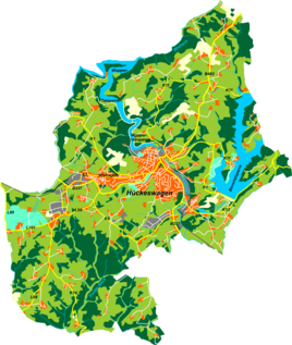
Location of Hammerstein in Hückeswagen |
||
Hammerstein (originally Hammersteinsoege ) is a formerly larger town in Hückeswagen in the Oberbergischer Kreis in the administrative district of Cologne in North Rhine-Westphalia , Germany .
After the dam of the Wuppertalsperre , the village only consists of a single house, the Hammerstein house .
Location and description
The location is in the northern Hückeswagen on a narrow peninsula in the Wuppertalsperre directly on its banks. Neighboring towns are Dürhagen , Vosshagen and, across the Wuppertalsperre, Karrenstein , Mittelhombrechen and Oberhombrechen .
The only building, Haus Hammerstein, is now a former hotel used by Lebenshilfe as an educational and recreational facility for people with disabilities . It can be reached via a two kilometer long access road, a dead end street that branches off from the K2 district road between Dörpmühle and Wiehagen and also connects Steffenshagen , Voßhagen and Dürhagen.
history
The place got the name "Hammerstein" from the noble family Hammerstein . A member of the family bought a farm in Wolfsoege . Later the place became known as "Hammersteinsoege". With the construction of the Wuppertalsperre the yard was demolished; the stones with the coat of arms of the von Hammerstein family were exhibited in the local museum in 2005.
The Topographia Ducatus Montani map from 1715 shows a farm named iunekern Oeu . Eight residents lived in the village in 1815/16. In 1832 Hammersteinsöge belonged to the Lüdorfer Honschaft , which was part of the Hückeswagen external citizenship within the Hückeswagen mayor . The place, which was categorized as a hamlet according to the statistics and topography of the Düsseldorf administrative district , had a residential building and two agricultural buildings at the time. At that time, eight people lived in the village, all of whom were Protestant.
Hammersteinsoege developed over time into a small town on the Wupper , where industrial companies also settled in the 19th to mid-20th centuries. The hydropower of the Wupper was used to generate electricity, among other things.
In the municipality lexicon for the Rhineland province , four houses with 76 inhabitants are given for 1885. At that time the place belonged to the rural community Neuhückeswagen within the Lennep district . In 1895 the place had five houses with 67 inhabitants, in 1905 six houses and 70 inhabitants.
During the Second World War , Soviet prisoners of war who had to do forced labor in the region were housed in an empty factory in the hamlet of Hammerstein as a subcamp of the main camp VI F in Bocholt . From Haus Hammerstein, which was not damaged in the war, they were provided with food. 44 forced laborers who perished due to work or illness were buried in the Soviet cemetery of honor in Vosshagen .
Due to the commissioning of the Wuppertalsperre in the 1980s, the place was demolished. Only the Hammerstein house, located on a small elevation , remained of the local buildings. When the water level in the dam is very low (most recently in 2003), various remains of building foundations and an old weir can still be seen. A specially designed water inlet for one of the factories can then be seen again.
leisure
The proximity of the Wuppertalsperre offers ample opportunities for recreational activities, e.g. B. Boating, swimming and hiking. From a vantage point and the medieval ring wall system Am Bilstein you have a beautiful view of Haus Hammerstein. It can be reached via the A 7 hiking trail.
Web links
- Hammerstein House today
- Hammerstein House at Lebenshilfe NRW
- History of the Hammerstein House ( Memento from May 28, 2013 in the Internet Archive ) on a private website
- Hammerstein's industrial history
Individual evidence
- ^ Johann Georg von Viebahn : Statistics and topography of the administrative district of Düsseldorf. Part 2: Containing the statistical table of places and distances and the alphabetical index of place names. Schreiner, Düsseldorf 1836, p. 12 .
- ^ Royal Statistical Bureau (Prussia) (Ed.): Community encyclopedia for the Rhineland province. Based on the materials from the census of December 1, 1885 and other official sources (= community encyclopedia for the Kingdom of Prussia. Vol. 12, ZDB -ID 1046036-6 ). Publishing house of the Royal Statistical Bureau, Berlin 1888.
- ^ Royal Statistical Bureau (Prussia) (Ed.): Community encyclopedia for the Rhineland province. Based on the materials from the census of December 1, 1895 and other official sources (= community encyclopedia for the Kingdom of Prussia. Vol. 12). Publishing house of the Royal Statistical Bureau, Berlin 1897.
- ^ Royal Statistical Bureau (Prussia) (Ed.): Community encyclopedia for the Rhineland province. Based on the materials from the census of December 1, 1905 and other official sources (= community encyclopedia for the Kingdom of Prussia. Vol. 12). Publishing house of the Royal Statistical Bureau, Berlin 1909.

