Crossroads (Hückeswagen)
|
crossroads
City of Hückeswagen
Coordinates: 51 ° 8 ′ 12 ″ N , 7 ° 17 ′ 39 ″ E
|
||
|---|---|---|
| Height : | 330 m | |
| Postal code : | 42499 | |
| Area code : | 02192 | |
|
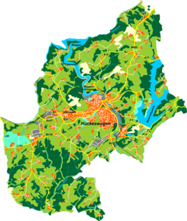
Location of Scheideweg in Hückeswagen |
||
Scheideweg is a village and district in Hückeswagen in the Oberbergischer Kreis in southern North Rhine-Westphalia within the administrative district of Cologne .
location
Scheideweg is on Landesstraße 68 between the Wermelskirchen district of Dabringhausen and Hückeswagen. An important connecting road to Wermelskirchen- Dhünn also ends there .
The place is characterized by a strongly expansive residential development and the convenient location. In the village itself, the organization for endangered aid Scheideweg is based, which also operates some companies and shops there. New Tribes Mission Germany also works there .
A golf course and the Winterhagen industrial area, which is the largest industrial area in Hückeswagen, are in the immediate vicinity.
Due to the increasing traffic, the citizens are now demanding a bypass road that relieves the town of through traffic. In 2004, the state road 68 was expanded with a footpath and bike path.
history
In 1858 the place was mentioned for the first time in a document.

