Christmas tree (Hückeswagen)
|
Christmas tree
City of Hückeswagen
Coordinates: 51 ° 8 ′ 34 " N , 7 ° 21 ′ 3" E
|
||
|---|---|---|
| Height : | 262 m above sea level NN | |
| Postal code : | 42499 | |
| Area code : | 02192 | |
|
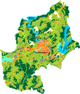
Location of Tannenbaum in Hückeswagen |
||
Tannenbaum is a residential and industrial location in Hückeswagen in the Oberbergisches Kreis in the administrative district of Cologne in North Rhine-Westphalia (Germany).
Location and transport links
Tannenbaum is located in the southern Hückeswagen in the Wupper valley on the federal road 237 . Neighboring towns are Hückeswagen Hartkopsbever , Dierl , Stahlschmidtsbrücke , Kobeshofen and Kleineichen . Tannenbaum has been an industrial site since the early 18th century.
history
As early as the 18th century there was a stone bridge over the Wupper in Tannenbaum, over which the road from Hückeswagen led into the Bevertal. In 1723, 1725 and 1740 three iron hammers were licensed and built by Nikolaus Biesenbach from Großeichen on the left side of the Wuppertal . A reservoir was created for the water supply. In 1793 a plate from Großeledder took over the works.
Further hammer mills are documented in 1758, one owned by Höfinghoff and one owned by Johan Daniel Clarenbach from the neighboring small oak. In 1782, Peter Johann Flender from Dörpe built another hammer mill in Tannenbaum.
In 1815/16 there were 21 residents in the village. In 1832, Tannenbaum belonged to the Berghauser Honschaft under the name Dannenbaum , which was part of the Hückeswagen external citizenship within the Hückeswagen mayor . The place, categorized as a craftsman's apartment and iron hammer according to the statistics and topography of the Düsseldorf administrative district , had a residential building, three hammer mills and two agricultural buildings at that time. At that time, 20 residents lived in the village, all of whom were evangelicals.
Before 1831, the ownership of one of the three hammer mills, the so-called Second Hammer , and a house square passed from Friedrich Forstmann zu Burg to Daniel Clarenbach from Hartkopsbever . In the same year a new residential building is built in the village and the third hammer is converted into a fruit mill .
A HW tipper from Mittelheukelbach , an iron manufacturer in Neuenhaus an der Bever , was Reidemeister of the first hammer in the village in 1832 . Whose hammer but was in a pre-1837 Schererei and Rauherei been converted. The second hammer was converted into a cloth factory by Raphael Clarenbach in 1837.
In the municipality lexicon for the province of Rhineland , eight houses with 82 inhabitants are given for 1885. At that time the place belonged to the rural community Neuhückeswagen within the Lennep district . In 1895 the place had eleven houses with 102 inhabitants, in 1905 nine houses and 91 inhabitants.
The Bergische Eisenstrasse led through Tannenbaum from Wipperfürth to Hückeswagen, today's dead end street An der Schlossfabrik . After the construction of the Chaussee to Wipperfürth, today's Bundesstraße 237, Tannenbaum was at the confluence of the Altstraße with the Chaussee.
Hiking and biking trails
The following hiking trails lead through the village:
- The Hückeswagener Rundweg ◯
Individual evidence
- ↑ a b c d Alfred Nehls: When the hammers roared in the valleys. The history of the iron industry in the Oberbergischer Kreis . Ed .: Heribert Rohr, senior district director of the Oberbergisches Kreis. Gronenberg, Wiehl 1996, ISBN 3-88265-200-4 , pp. 301 .
- ^ Johann Georg von Viebahn : Statistics and topography of the administrative district of Düsseldorf. Part 2: Containing the statistical table of places and distances and the alphabetical index of place names. Schreiner, Düsseldorf 1836, p. 13 .
- ↑ a b c d e Alfred Nehls: When the hammers roared in the valleys. The history of the iron industry in the Oberbergischer Kreis . Ed .: Heribert Rohr, senior district director of the Oberbergisches Kreis. Gronenberg, Wiehl 1996, ISBN 3-88265-200-4 , pp. 346 .
- ^ Royal Statistical Bureau (Prussia) (Ed.): Community encyclopedia for the Rhineland province. Based on the materials from the census of December 1, 1885 and other official sources (= community encyclopedia for the Kingdom of Prussia. Vol. 12, ZDB -ID 1046036-6 ). Publishing house of the Royal Statistical Bureau, Berlin 1888.
- ^ Royal Statistical Bureau (Prussia) (Ed.): Community encyclopedia for the Rhineland province. Based on the materials from the census of December 1, 1895 and other official sources (= community encyclopedia for the Kingdom of Prussia. Vol. 12). Publishing house of the Royal Statistical Bureau, Berlin 1897.
- ^ Royal Statistical Bureau (Prussia) (Ed.): Community encyclopedia for the Rhineland province. Based on the materials from the census of December 1, 1905 and other official sources (= community encyclopedia for the Kingdom of Prussia. Vol. 12). Publishing house of the Royal Statistical Bureau, Berlin 1909.

