Rautzenberg
|
Rautzenberg
City of Hückeswagen
Coordinates: 51 ° 6 ′ 31 ″ N , 7 ° 19 ′ 35 ″ E
|
||
|---|---|---|
| Height : | 285 m above sea level NN | |
| Postal code : | 42499 | |
| Area code : | 02192 | |
|
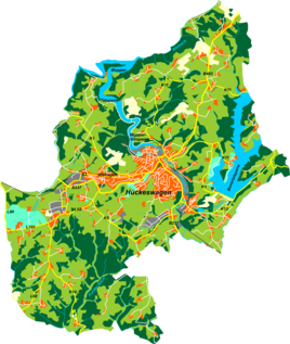
Location of Rautzenberg in Hückeswagen |
||
Rautzenberg is a court in Hückeswagen in the Oberbergisches Kreis in the administrative district of Cologne in North Rhine-Westphalia (Germany).
Location and transport links
Rautzenberg is located in southern Hückeswagen on the border with Wipperfürth . Neighboring towns are Niederburghof , Oberburghof , Kaisersbusch , Warth , Odenhollermühle and Wipperfürth-Niederdhünn. The place can be reached via a connecting road that branches off from Kreisstraße 5 at Altenholte and leads to federal road 506 at Wipperfürth- Schniffelshöh .
The village is located in the catchment area of the Große Dhünn brook , which flows into the Große Dhünntalsperre .
history
The place was mentioned for the first time in 1374 : “The Cologne St. Ursulastift u. a. from the Hofe op dem Rosenberg in the parish of Hückeswagen ”. Spelling of the first mention: op dem Rosenberg .
In the 18th century the place belonged to the Bergisches Amt Bornefeld-Hückeswagen . In 1815/16 there were 39 people living in the village. In 1832, Rautzenberg belonged under the name of Rauzenberg to the Great Honorship , which was part of the Hückeswagen external citizenship within the Hückeswagen mayorry . The place, categorized as a hamlet according to the statistics and topography of the Düsseldorf administrative district , had five residential buildings and nine agricultural buildings at that time. At that time 32 people lived in the place, six Catholic and 26 Protestant faith.
In the municipality lexicon for the Rhineland province , five houses with 34 inhabitants are given for 1885. At that time the place belonged to the rural community Neuhückeswagen within the Lennep district . In 1895 the place had two houses with 14 inhabitants, in 1905 two houses and 15 inhabitants.
Individual evidence
- ^ Johann Georg von Viebahn : Statistics and topography of the administrative district of Düsseldorf. Part 2: Containing the statistical table of places and distances and the alphabetical index of place names. Schreiner, Düsseldorf 1836, p. 10 .
- ^ Royal Statistical Bureau (Prussia) (Ed.): Community encyclopedia for the Rhineland province. Based on the materials from the census of December 1, 1885 and other official sources (= community encyclopedia for the Kingdom of Prussia. Vol. 12, ZDB -ID 1046036-6 ). Publishing house of the Royal Statistical Bureau, Berlin 1888.
- ^ Royal Statistical Bureau (Prussia) (Ed.): Community encyclopedia for the Rhineland province. Based on the materials from the census of December 1, 1895 and other official sources (= community encyclopedia for the Kingdom of Prussia. Vol. 12). Publishing house of the Royal Statistical Bureau, Berlin 1897.
- ^ Royal Statistical Bureau (Prussia) (Ed.): Community encyclopedia for the Rhineland province. Based on the materials from the census of December 1, 1905 and other official sources (= community encyclopedia for the Kingdom of Prussia. Vol. 12). Publishing house of the Royal Statistical Bureau, Berlin 1909.

