Goat
|
Goat
City of Hückeswagen
Coordinates: 51 ° 6 ′ 47 ″ N , 7 ° 16 ′ 46 ″ E
|
||
|---|---|---|
| Height : | 280 m above sea level NN | |
| Postal code : | 42499 | |
| Area code : | 02192 | |
|
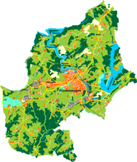
Location of jacks in Hückeswagen |
||
|
Bockhacken village
|
||
Bockhacken is a village in Hückeswagen in the Oberbergischer Kreis in the administrative district of Cologne in North Rhine-Westphalia (Germany).
Location and description
Bockhacken is located in the southwest of Hückeswagen on the border with Wermelskirchen near Straßweg . Other neighboring towns are Kotthausen , Strasbourg , Schückhausen Wermelskirchen-Staelsmühle, Wermelskirchen-Haarhausen and Wermelkirchen-Bergstadt. The place is on the L68 road between Straßweg and Wermelskirchen-Neuenhaus.
Bockhacken lies in the headwaters of the Kleine Dhünn brook , which flows into the Große Dhünntalsperre .
In Bockhacken there is an adventure farm where children and young people from the region get to know agriculture and forestry through adventure camps. A little outside of Bockhacken there was a large Deutsche Welle measuring and receiving system on a hill since 1964 . At the end of 2017 the facility was completely closed and the antennas dismantled.
history
The map Topographia Ducatus Montani from 1715 shows a single courtyard and denotes it with a goat. The topographical survey of the Rhineland from 1825 shows eight separate floor plans for the site in a delimited courtyard.
In the 18th century the place belonged to the Bergisches Amt Bornefeld-Hückeswagen . In 1815/16 there were 35 people living in the village. In 1832, Bockhacken belonged to the Great Honorship , which was part of the Hückeswagen external citizenship within the Hückeswagen mayor . The place, categorized as a hamlet according to the statistics and topography of the Düsseldorf administrative district , had six residential buildings and nine agricultural buildings at the time. At that time there were 41 inhabitants, two of them Catholic and 39 Protestant.
In the municipality lexicon for the province of Rhineland , five houses with 32 inhabitants are given for 1885. At that time the place belonged to the rural community Neuhückeswagen within the Lennep district . In 1895 the place had six houses with 37 inhabitants, in 1905 five houses and 30 inhabitants.
Hiking and biking trails
The following hiking trails lead through the village:
- The SGV main hiking route X19 ( Schlösserweg ) from Düsseldorf to Dillenburg
- The Wermelskirchen local circular route A3
Individual evidence
- ↑ Bock hacking at dw.com
- ^ Historika25, State Surveying Office NRW, sheet 4809, Remscheid
- ^ Johann Georg von Viebahn : Statistics and topography of the administrative district of Düsseldorf. Part 2: Containing the statistical table of places and distances and the alphabetical index of place names. Schreiner, Düsseldorf 1836, p. 11 .
- ^ Royal Statistical Bureau (Prussia) (Ed.): Community encyclopedia for the Rhineland province. Based on the materials from the census of December 1, 1885 and other official sources (= community encyclopedia for the Kingdom of Prussia. Vol. 12, ZDB -ID 1046036-6 ). Publishing house of the Royal Statistical Bureau, Berlin 1888.
- ^ Royal Statistical Bureau (Prussia) (Ed.): Community encyclopedia for the Rhineland province. Based on the materials from the census of December 1, 1895 and other official sources (= community encyclopedia for the Kingdom of Prussia. Vol. 12). Publishing house of the Royal Statistical Bureau, Berlin 1897.
- ^ Royal Statistical Bureau (Prussia) (Ed.): Community encyclopedia for the Rhineland province. Based on the materials from the census of December 1, 1905 and other official sources (= community encyclopedia for the Kingdom of Prussia. Vol. 12). Publishing house of the Royal Statistical Bureau, Berlin 1909.


