Dourges
| Dourges | ||
|---|---|---|

|
|
|
| region | Hauts-de-France | |
| Department | Pas-de-Calais | |
| Arrondissement | Lens | |
| Canton | Hénin-Beaumont-1 | |
| Community association | Henin-Carvin | |
| Coordinates | 50 ° 26 ' N , 2 ° 59' E | |
| height | 23-35 m | |
| surface | 10.48 km 2 | |
| Residents | 5,891 (January 1, 2017) | |
| Population density | 562 inhabitants / km 2 | |
| Post Code | 62119 | |
| INSEE code | 62274 | |
| Website | http://www.courcelles-les-lens.fr/ | |
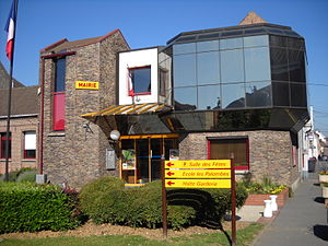
 Dourges Town Hall |
||
Dourges is a French municipality with 5891 inhabitants (as of January 1 2017) in the department of Pas-de-Calais in the region Nord-Pas-de-Calais . It belongs to the Arrondissement of Lens and the canton of Hénin-Beaumont-1 . The inhabitants arecalled the Dourgeois .
geography
The canalised Deûle , here part of the large shipping route Dunkirk-Scheldt , runs right through the municipality. Dourges is surrounded by the neighboring communities of Oignies in the north, Ostricourt in the northeast, Évin-Malmaison in the east, Noyelles-Godault in the south and southeast, Hénin-Beaumont in the southwest and Carvin in the west. The districts of the municipality include Bourcheuil , Harponlieu and Wavrechin .
This is where the A1 auto route intersects with the A21 auto route .
history
In 1338 Bourcheuil appears as a property in the Johanniter books of their estates. Mines have been driven into the mountain at Dourges since 1855 . Coal mining continued into the 20th century. The last mine was closed in 1991. Bourcheuil was an independent municipality until 1821 and was then united with Dourges .
Population development
| 1962 | 1968 | 1975 | 1982 | 1990 | 1999 | 2006 | 2011 |
|---|---|---|---|---|---|---|---|
| 5,162 | 5,746 | 5,402 | 5,201 | 5,806 | 5,676 | 5,641 | 5,651 |
Attractions
- Saint Stanislas Church , Monument historique
- Church Saint-Piat
- Ruins of the château and the old manor
- Military cemeteries for French, British and German soldiers who died in the First World War


